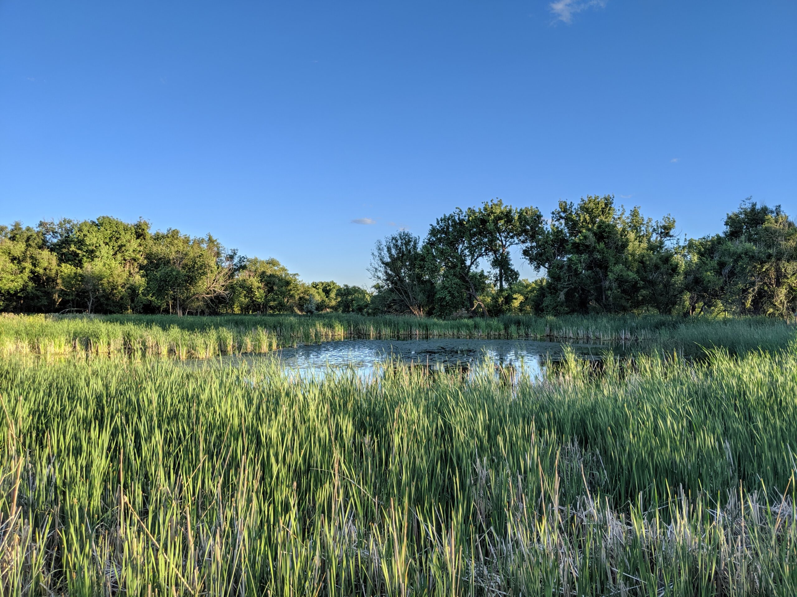
Cattail Marsh Wildlife Area
Cattail Marsh Wildlife Area in Fountain, CO is a quiet oasis tucked along the banks of Fountain Creek, offering one of the region’s best spots for birdwatching and nature observation. This wetland habitat, shaped by cattails, marsh grasses, and open water, provides an essential refuge for migratory birds and local wildlife while giving visitors a peaceful place to connect with nature.
Trails and Recreation
Visitors can enjoy a short network of natural-surface paths that weave through cattail stands and around marshy ponds. These trails are flat and easy, making them perfect for a leisurely walk, wildlife photography, or a quiet moment in nature. The area also links with the broader Fountain Creek Regional Trail system, offering opportunities for longer walks or bike rides.
Wildlife & Scenery
As its name suggests, the marsh is alive with wildlife. More than 200 bird species have been spotted here, including red-winged blackbirds, herons, egrets, ducks, and seasonal sandhill cranes. Turtles, frogs, and beavers also make their home in the wetlands, while deer and foxes are often seen at the edges. The cattail stands create striking reflections in the ponds, especially at sunrise and sunset.
Fountain Creek Nature Center
Located within Fountain Creek Regional Park next to the marsh, the Fountain Creek Nature Center serves as the gateway to the area. The center features interactive exhibits on wetlands ecology, wildlife displays, and panoramic windows overlooking the marsh. It also hosts year-round educational programs, guided hikes, and children’s activities that connect people of all ages to the importance of wetlands and riparian ecosystems.
History
Cattail Marsh was conserved as part of the broader effort to protect Fountain Creek’s riparian corridor and preserve valuable wetlands in southern El Paso County. These wetlands are not only scenic but also play a critical ecological role, filtering water and supporting biodiversity in an otherwise urbanizing landscape.
Plan Your Visit
Location: 320 Peppergrass Ln, Fountain, CO 80817 (adjacent to Fountain Creek Regional Park)
Hours: Open daily from dawn to dusk
Parking: Available at the Fountain Creek Nature Center and nearby trailheads
Know Before You Go: Dogs must remain leashed to protect wildlife. Trails can be muddy in spring and after heavy rain—wear appropriate footwear and bring binoculars for the best birding experience.
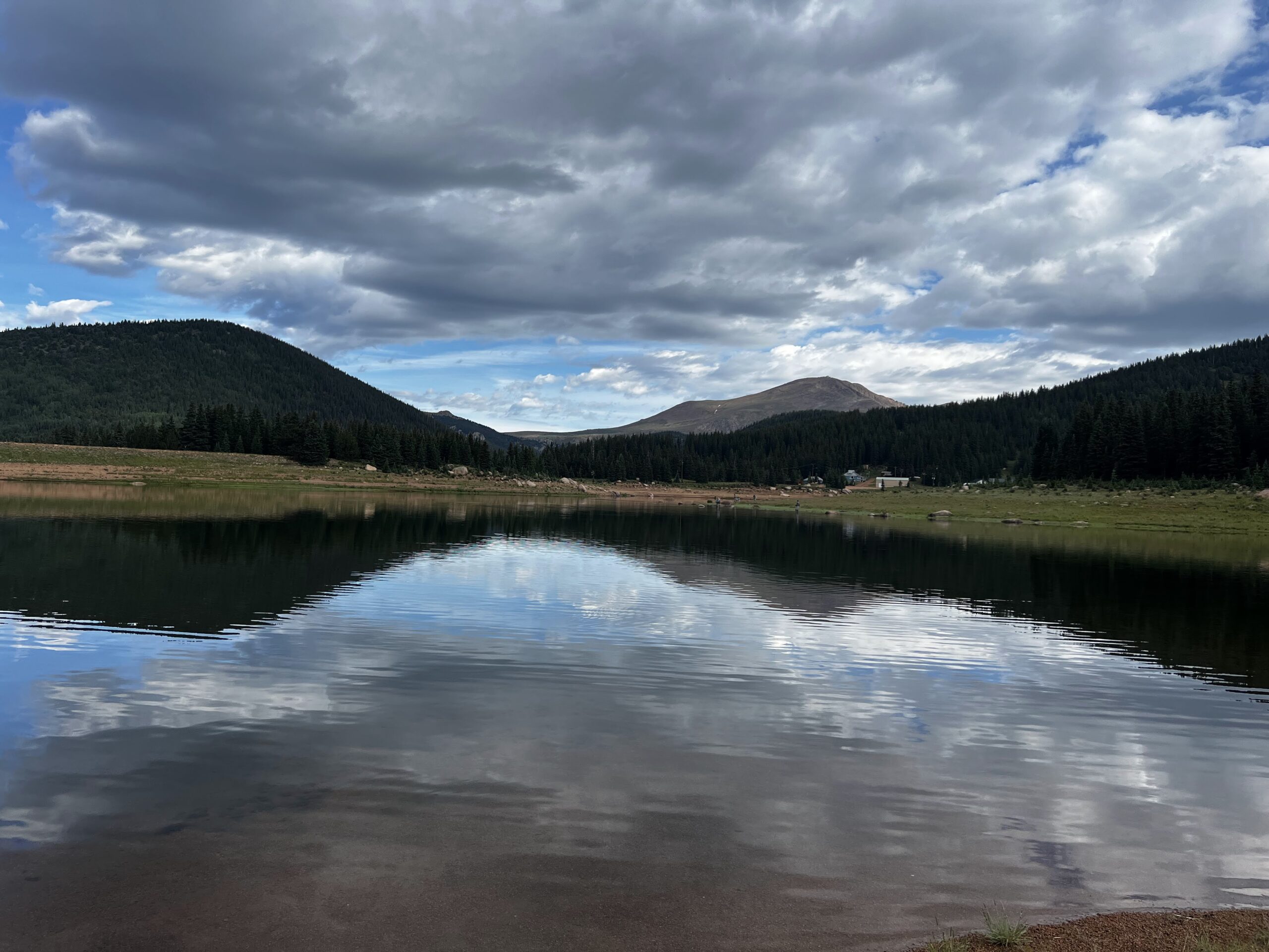
South Slope Recreation Area on Pikes Peak
South Slope Recreation Area, located on the south side of Pikes Peak, is a high-alpine escape offering fishing, hiking, and solitude in one of Colorado’s most pristine mountain settings. Managed by Colorado Springs Utilities, this limited-access recreation area is known for its sparkling reservoirs, uncrowded trails, and unbeatable views of America’s Mountain.
Reservoirs and Recreation
The South Slope includes two reservoirs—Mason Reservoir and McReynolds Reservoir—that are open to non-motorized boating and fishing. Anglers can try their luck for cutthroat and rainbow trout, while kayakers, canoeists, and paddleboarders enjoy calm waters surrounded by pine forest and rugged ridgelines. Fishing is regulated to protect water quality, so visitors should review posted guidelines before heading out.
Trails and Wildlife
Several scenic trails showcase the area’s alpine beauty. The Mason Trail offers moderate hiking along the reservoir shoreline, while higher-elevation routes climb toward stunning overlooks and connect to backcountry terrain. Wildlife is abundant—visitors may spot marmots, elk, mule deer, raptors, and even black bear. At over 11,000 feet in elevation, the South Slope is also a cool retreat during Colorado’s hot summer months.
Limited Access and Conservation
Unlike the busier North Slope Recreation Area, the South Slope is managed with limited daily permits to preserve its fragile alpine environment and protect the City’s drinking water supply. Reservations are required and visitor numbers are capped each day, making this one of the quietest and most exclusive outdoor experiences on Pikes Peak.
Plan Your Visit
-
Location: Accessed via Old Stage Road and Gold Camp Road, southwest of Colorado Springs.
-
Parking: A gravel parking lot is available near the Mason Reservoir trailhead. Space is limited and included with a valid day permit.
-
Hours: Open seasonally. Public access hours are limited.
-
Fees: Entry requires a daily permit, available online through Colorado Springs Utilities. A valid fishing license is required for anglers.
-
Tips: Dress in layers—weather changes quickly at 11,000 feet. Cell service is limited, so plan ahead. Pets are not allowed to protect sensitive wildlife and water quality.
With its serene reservoirs, alpine trails, and limited-access wilderness feel, South Slope Recreation Area is one of the most unique outdoor adventures on Pikes Peak.
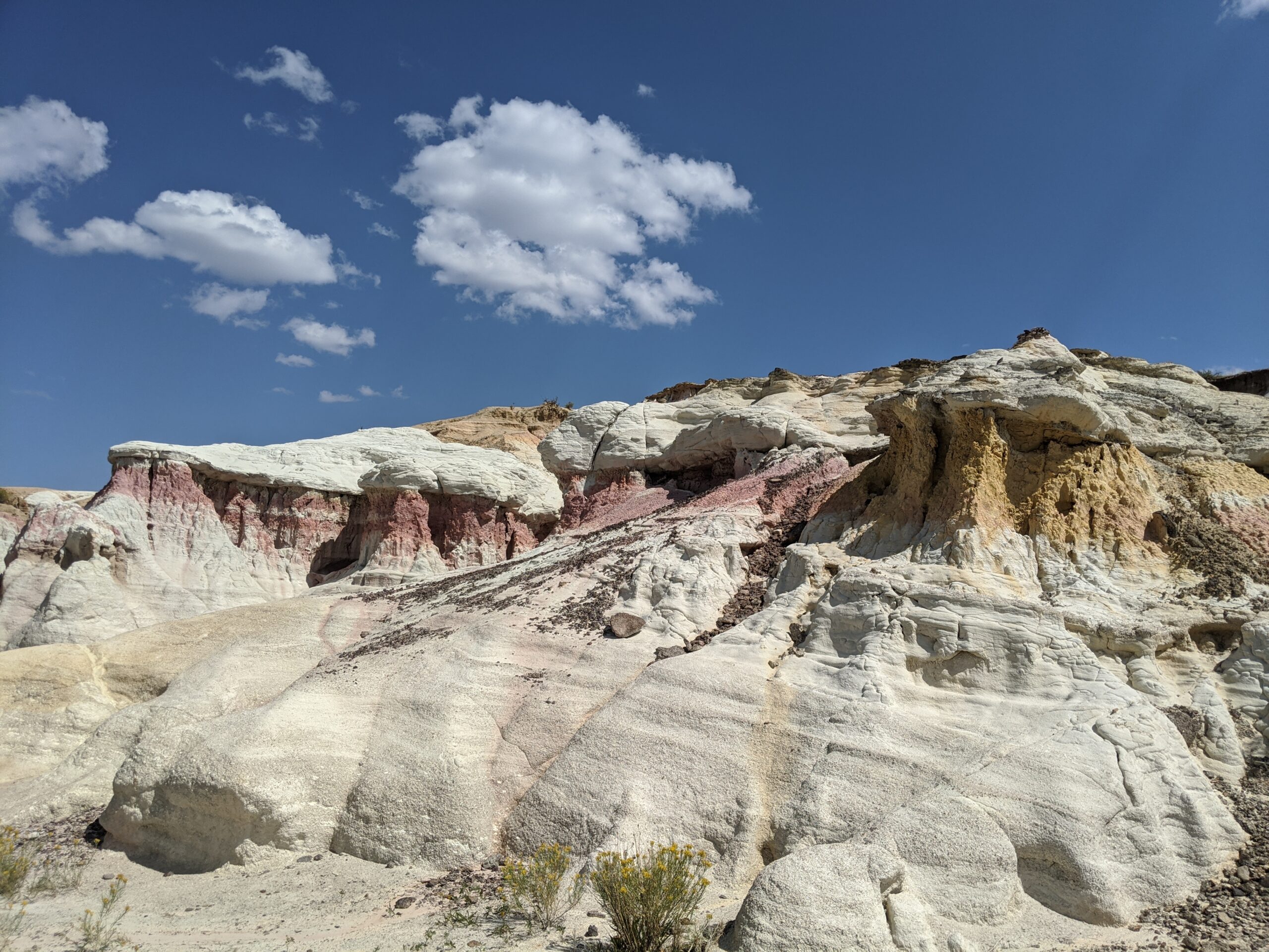
Paint Mines Interpretive Park
Paint Mines Interpretive Park, located near Calhan in El Paso County, Colorado, is one of the region’s most unique and colorful natural treasures. Covering 750 acres, the park is famous for its dramatic hoodoos, spires, and sculpted clay formations layered in shades of red, yellow, orange, and purple. Rich in both natural and cultural history, the Paint Mines offer a rare glimpse into the geology and heritage of Colorado’s eastern plains.
Trails and Recreation
The park features four miles of interpretive trails that wind through rolling prairie and into the vibrant badlands below. Trails are non-motorized and open to hikers, trail runners, and families seeking a one-of-a-kind outdoor experience. Interpretive signs along the way highlight the park’s geology, ecology, and human history. Because the formations are fragile, visitors are asked to stay on designated trails.
History and Archaeology
The Paint Mines have been a cultural landmark for thousands of years. Archaeological evidence shows that Native American peoples, including the Apache and Comanche, used the colorful clay for pottery and ceremonial paints as far back as 9,000 years ago. Remnants of quarrying and stone tools have been found throughout the park, underscoring its importance as both a natural and cultural resource.
Wildlife and Scenery
Beyond its geologic wonders, the park is home to pronghorn, coyotes, mule deer, and a variety of grassland birds. In spring and summer, wildflowers add bursts of color to the prairie, while sweeping views of Pikes Peak rise in the distance. The contrast of bright rock formations against the open sky makes this one of the most photogenic landscapes in El Paso County.
Plan Your Visit
Paint Mines Interpretive Park is located just south of Calhan, Colorado, about 35 miles northeast of Colorado Springs. Parking, restrooms, and trailhead access are available at the main entrance off Paint Mine Road. The park is open daily from dawn to dusk, with no entrance fee. Dogs and other pets are not permitted, in order to protect fragile resources and wildlife.
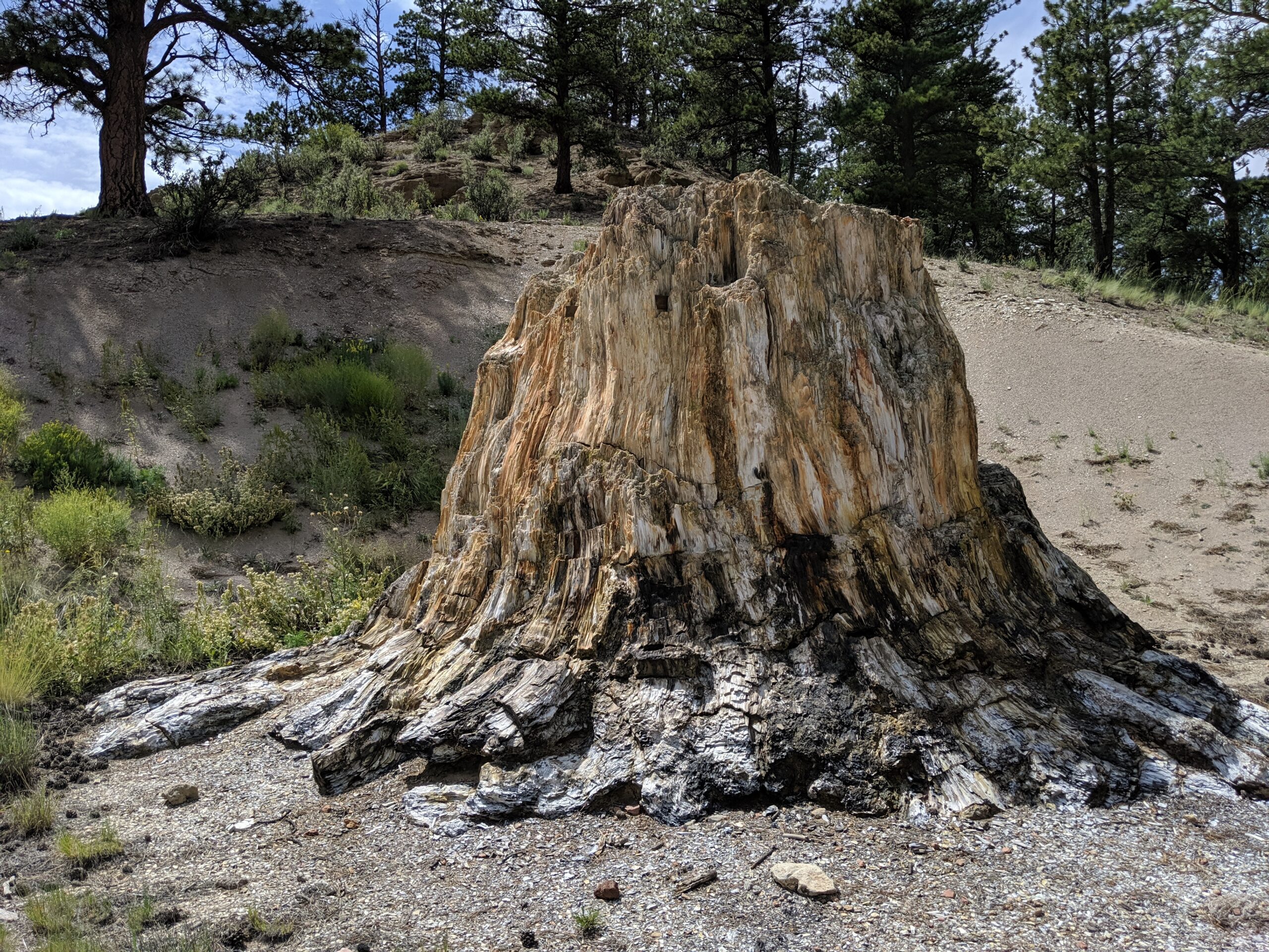
Florissant Fossil Beds National Monument
Florissant Fossil Beds National Monument in Teller County, Colorado, protects one of the richest fossil deposits in the world. Covering more than 6,000 acres, this National Park Service site offers visitors a rare opportunity to explore ancient history, dramatic geology, and the beauty of Colorado’s mountain landscape all in one place.
Trails and Recreation
The Monument features 14 miles of hiking trails, ranging from short family-friendly loops to longer treks through forests, meadows, and past historic homesteads. Popular trails include the Petrified Forest Loop, which showcases massive fossilized redwood stumps, and the Hornbek Homestead Trail, offering a glimpse of 19th-century pioneer life. Ranger-led programs, fossil displays, and interactive exhibits at the visitor center make this a perfect stop for families, students, and curious explorers.
Fossils and Geology
The Florissant valley was once a subtropical ecosystem, home to towering redwoods, giant insects, and hundreds of plant species. Volcanic eruptions 34 million years ago buried the valley in ash, preserving thousands of fossils in fine-grained shale. Today, visitors can see petrified tree stumps up to 14 feet wide and view one of the most diverse insect fossil collections ever discovered.
Wildlife and Scenery
Beyond fossils, the Monument is a haven for wildlife. Elk, mule deer, black bear, and fox are frequently spotted, along with a wide variety of birds including mountain bluebirds and hummingbirds. Open meadows dotted with wildflowers and sweeping views of Pikes Peak provide a stunning backdrop year-round.
History
In addition to its prehistoric treasures, Florissant Fossil Beds preserves the Hornbek Homestead, a restored 1870s ranch house that tells the story of early Colorado pioneers. Archaeological evidence also shows that Native American groups, including the Ute, visited the valley for thousands of years.
Plan Your Visit
The Monument is located just west of the town of Florissant, Colorado, about 35 miles from Colorado Springs. The visitor center is open year-round (with seasonal hours), offering exhibits, a bookstore, and trail access. A small entrance fee is required; federal passes are accepted.
With its unique combination of world-class fossils, scenic hiking, and rich human history, Florissant Fossil Beds National Monument is one of Colorado’s most fascinating places to explore.
Corral Bluffs
Located east of Colorado Springs, Corral Bluffs is a nationally significant landscape known for its fossil resources, sweeping plains, and dramatic views of the Front Range. The area is managed for conservation and scientific research and is not open to the general public, helping protect sensitive paleontological and natural resources.
Recreation and Access
Corral Bluffs is closed to unsupervised public access. Entry is only permitted during special guided hikes and educational programs, which are offered periodically in partnership with land managers and conservation organizations. These guided experiences provide a rare opportunity to explore the landscape, learn about its geology and fossils, and understand why long term protection is critical.
Because access is limited, visitors should not attempt to enter Corral Bluffs outside of permitted programs. Doing so can damage sensitive resources and may result in enforcement action.
Landscape and Scientific Significance
Corral Bluffs is internationally recognized for its fossil beds, which have contributed to scientific understanding of life following the mass extinction event that ended the age of dinosaurs. The area contains layered rock formations, prairie ecosystems, and wide open vistas that illustrate millions of years of natural history.
In addition to its paleontological value, Corral Bluffs provides important habitat for grassland species and plays a role in regional conservation efforts aimed at protecting open landscapes east of Colorado Springs.
History and Conservation
Protection of Corral Bluffs has been driven by decades of collaboration among scientists, conservation organizations, and public agencies. The area has become a model for balancing research, conservation, and carefully managed public education.
Guided access programs allow the public to engage with this extraordinary landscape while ensuring fossils and fragile ecosystems remain intact for future study and stewardship.
Plan Your Visit
Location: Eastern El Paso County, east of Colorado Springs
Access: Not open to the public; guided hikes only
Parking: Provided only for permitted guided programs
Fees: Vary by program
Tips:
-
Watch for announcements about guided hikes and educational events
-
Never collect fossils or remove natural materials
-
Respect closures and posted boundaries at all times
Corral Bluffs is a reminder that some of the most important places are protected by limiting access. Through guided experiences and continued conservation, this remarkable landscape is preserved for science, education, and future generations.
Bluestem Prairie Open Space offers 646 acres of prairie grassland and bird watching paradise. Home to over 200 bird species and several mammal species, Bluestem Prairie Open Space has become a refuge for a variety of native wildlife and vegetation. Roughly 9 miles of flowing, dirt single track trail make it an ideal location for beginner mountain bikers. The area has no shade, bring plenty of water if you visit in the summer, we recommend visiting early in the morning or evening.
NOTE: No dogs allowed, due to native wildlife.
History: Located just south of the Colorado Springs Municipal Airport, this land once belonged to the Banning-Lewis Ranch. Here ranchers relied primarily on rich soils and thriving grasslands to survive. This land remains home to varied mammals such as the Pronghorn, the Black-tailed prairie dog and birds like the Red-tailed hawk, Burrowing owls and Migratory Shorebirds.
In the fall of 2000, the Trust for Public Land purchased the Big Johnson property from Cygnet Land, LLC and then conveyed the property to the City of Colorado Springs. The City used funds from its Trails, Open Space, and Parks (TOPS) sales tax and a grant from Great Outdoors Colorado (GOCO) to acquire the property. View BIG JOHNSON OPEN SPACE MASTER PLAN.
The namesake “bluestem” highlights the tallgrass species found in northwest portion of the property, while the more predominant shortgrass community in the bowl-shaped valley surrounds the privately-owned Big Johnson Reservoir. The Bluestem Prairie Open Space Management Plan was adopted by the Park and Recreation Advisory Board on March 10, 2016.
The Manitou Incline is one of the most popular hiking trails in Colorado. The base of the Incline sits at 6,600 feet. It is, perhaps, the most unique and challenging trail in the country, attracting runners, military, Olympic athletes, and hiking enthusiasts from around the world. It is steep, gaining over 2,011 feet of elevation in 0.88 mile. There are approximately 2,750 steps, although the top step is numbered “2768”; the number of steps changes occasionally with trail maintenance and deterioration. While some athletes can conquer the Incline in 30 minutes or less, it takes most people 1-3 hours to make it to the top. Plus, an additional 1-2 hours to return down the Barr Trail. After you crest the false summit, there are approximately 300 steps to go before reaching the top.
The base of the Incline is located in Manitou Springs near the Cog Railroad. The Inline is free and open to the public, but expect to pay for parking. Even with paid parking, finding a spot can be difficult. In the summer, plan to park in the lot at 10 Old Man’s Trail or in Manitou Springs and take the free shuttle.
PLEASE NOTE: Starting in 2020, users are required to make a FREE reservation online, at coloradosprings.gov/parks/page/manitou-incline. Pets are NOT allowed on the Incline. Remember to bring plenty of water!! This is an extremely difficult climb at high altitude, and the return route on Barr Trail is about 3 miles, it’s about 4 miles round trip. You should be in good physical shape and acclimated to Colorado altitude before attempting this trail.
Connections: The Northern Incline Return Trail offers two new return options for hikers, both located in the bottom half of the Incline. The first return is located at railroad tie #395 and the second is at #1300, approximate halfway point. From tie #1300, the trail to return down to the trailhead is roughly 1.5 miles. From tie #395, it is about a half a mile hike down. About three-quarters of the way up the Incline, around step #1800 there is a turnoff to the Barr Trail, locally called “The Bailout.” If you don’t have it in you to take on another 1000 steps, this is where you should exit. The top of the Incline also connects to Barr Trail allowing hikers to trek to the summit of Pikes Peak or return to the base of the Incline.
History: Completed in 1907, the Manitou Incline was once a cable tram built to support the construction of a hydroelectric plant and its waterline. After performing this service the railway was then purchased by Dr. Brumbach and turned into a tourist attraction. The Incline boasted a 16-minute ride to “scenic splendors”, 10 miles of hiking trails in Mount Manitou Park, and claimed to be the “longest and highest incline on the globe.” Spencer Penrose bought the Incline in 1923 and made it part of his tourist attraction empire, the cars were upgraded to allow for a retractable roof and more safety. The summit station was again rebuilt in 1958 and lasted until it was dismantled upon closure of the Incline in 1990. A rock slide damaged a section of track in 1990, so the Manitou Springs Incline was closed down. The rails were removed, but the railroad ties remained in the form of a massive staircase.
Nearly 20 years of unmanaged trespass and use of the Incline resulted in significant erosion on the mountainside, dangerous trail conditions, traffic congestion and uncontrolled parking. In 2010, the City of Colorado Springs negotiated pursing legal access to the Incline corridor, and both Colorado Springs and Manitou Springs entered into an Intergovernmental Agreement to plan for formally opening the Incline for public recreation. In 2011, the Manitou Incline Site Development and Management Plan was drafted. After many years of wrangling and an actual Act of Congress, the Incline was made legal in February of 2013.
Volunteer: Contact the Incline Friends to see how you can help, inclinefriends@gmail.com.