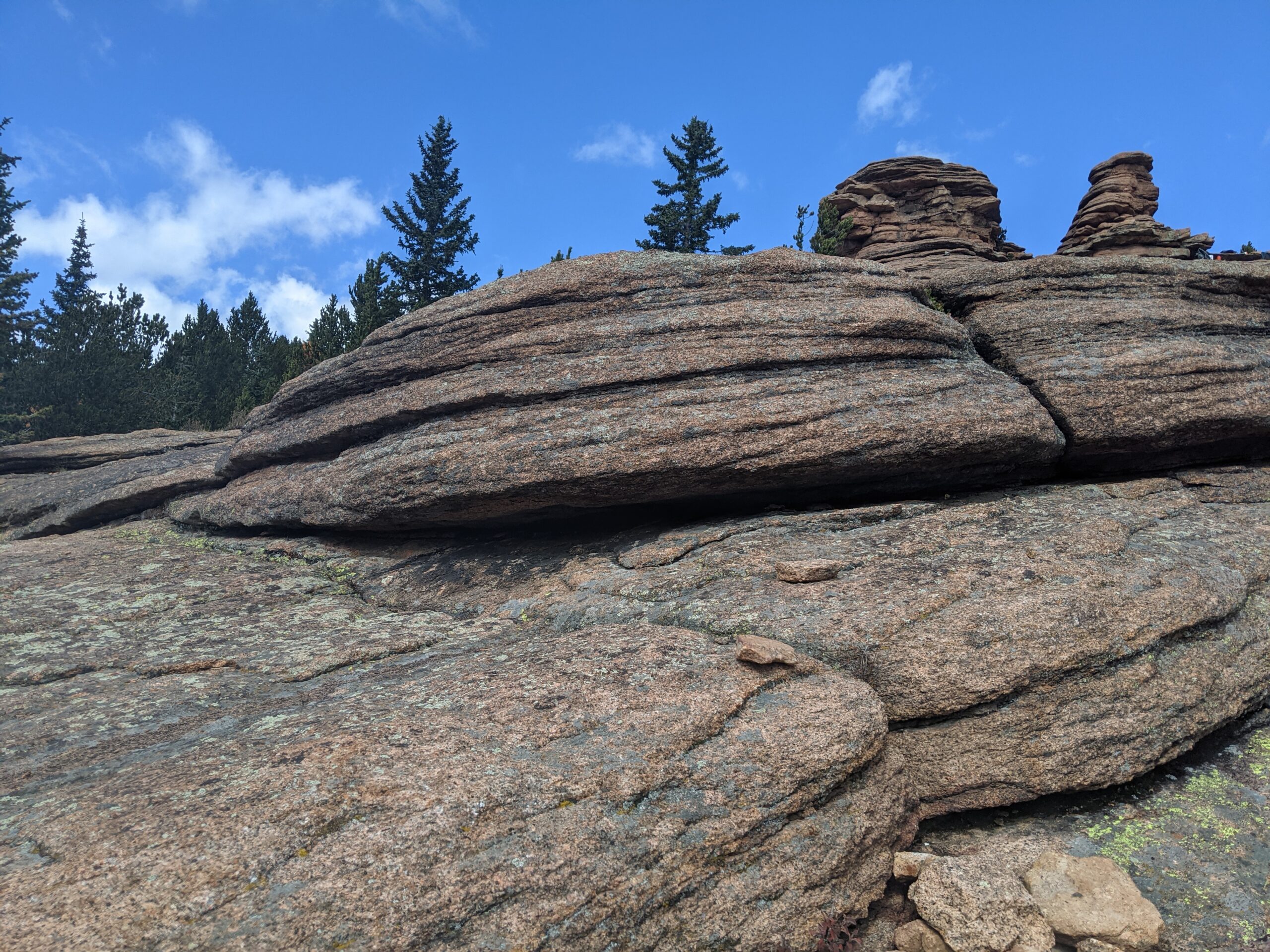
Pancake Rocks Trail
The Pancake Rocks Trail near Cripple Creek is one of the most beloved high-country hikes in the Pikes Peak region, famous for its unusual, layered rock formations that resemble a towering stack of pancakes. At over 10,000 feet in elevation, this hike combines geological wonders, sweeping views, and a true alpine adventure.
Trails and Hiking
The trail to Pancake Rocks begins from Horsethief Park and climbs steadily through spruce and fir forest. Hikers can expect about 6 miles round trip with roughly 1,200 feet of elevation gain, making it a moderate-to-challenging trek. The highlight is reaching the natural sandstone and granite formations, where the rock has weathered into stacked, flat shelves that look like giant pancakes tipped on their side.
Wildlife and Scenery
Along the way, hikers are treated to dense forest, alpine meadows, and breathtaking views of Pikes Peak’s south slopes and the surrounding Teller County high country. Wildlife sightings often include marmots, pikas, mule deer, and a variety of alpine birds. In late summer, wildflowers add splashes of color to the meadows, while fall brings golden aspen groves.
History
The Pancake Rocks area has long been a favorite local hike, with its unique formations formed over millions of years by erosion and uplift. Once traveled by miners and early settlers moving between Cripple Creek and Divide, today it is a treasured recreational destination managed by the Pike National Forest.
Plan Your Visit
Location: Access off CO Highway 67 between Divide and Cripple Creek. The Horsethief Park Trailhead is closest.
Parking: Parking strip along HWY with various pulloffs further away.
Hours: Open year-round, though snow and ice can make the trail difficult outside of summer and fall.
Tips:
-
At high elevation, weather changes quickly—dress in layers and be prepared for storms.
-
Bring plenty of water; there are no reliable water sources on the trail.
-
Dogs are allowed but should be leashed to protect wildlife and fellow hikers.
-
Start early to avoid afternoon thunderstorms common in summer.
With its striking rock formations and spectacular alpine views, Pancake Rocks is a one-of-a-kind hike that rewards every step of the climb.
Cottonwood Creek Trail – Colorado Springs, CO
Cottonwood Creek Trail is a major east west urban trail in northern Colorado Springs and a key connector within the city’s trail system. Following Cottonwood Creek, the trail links neighborhoods, parks, and regional trail corridors while providing a smooth and accessible route for everyday recreation and transportation.
Location: Northern Colorado Springs, following Cottonwood Creek from Powers Boulevard to the Pikes Peak Greenway near I 25
Trail Experience
Cottonwood Creek Trail is just over 6 miles long and features a smooth concrete surface throughout. The trail runs east to west along Cottonwood Creek, beginning near Frank Castello Park at Powers Boulevard and continuing west to connect with the Pikes Peak Greenway and Front Range Trail near I 25.
The trail is generally flat with gentle elevation changes, making it accessible for walkers, runners, cyclists, families, and users of mobility devices. The corridor offers a mix of riparian habitat, open space, and neighborhood views, with long straight segments that are well suited for longer outings or commuting. Benches, trail access points, and nearby amenities allow users to easily tailor trips to their preferred distance and pace.
A dirt trail alternative runs between Union Boulevard and Rangewood Drive, providing a more natural surface option and forming a pleasant 3 mile loop with convenient parking at Cottonwood Creek Community Park.
Road Crossings and Navigation
Cottonwood Creek Trail includes one major street crossing at Union Boulevard. Trail users should use the marked crosswalk at Woodland Hills Drive when crossing Union Boulevard. The trail passes alongside Frank Castello Park and includes a spur connection to Dublin Park; however, accessing Dublin Park requires crossing Dublin Boulevard, which currently does not have a designated pedestrian crossing.
Connections
Cottonwood Creek Trail connects directly to the Pikes Peak Greenway and Front Range Trail just south of the Woodmen Road and Rockrimmon Boulevard area. Multiple neighborhood access points provide easy connections to Cottonwood Creek Community Park, nearby residential areas, and the YMCA. The trail also links to Woodmen Trail and other local trail segments, strengthening north south and east west connectivity across northern Colorado Springs.
Sand Creek Trail – Colorado Springs, CO
Sand Creek Trail is an evolving multi segment trail system in Colorado Springs that follows Sand Creek through residential areas, parks, and open spaces. When complete, the trail will serve as an important east west and north south connector, linking neighborhoods to recreation facilities and the city’s larger trail network.
Location: Eastern and southeastern Colorado Springs, following Sand Creek from Woodmen Road to Airport Road
Trail Experience
Sand Creek Trail is currently made up of two primary segments that are not yet connected. Each segment is approximately 4 miles in length and offers a different trail experience depending on location and surface type.
The southern segment runs diagonally through southeast Colorado Springs, beginning near El Pomar Youth Sports Park and extending east toward Wildflower Park. From Wildflower Park, the main trail continues north of Airport Road, while the East Fork Sand Creek spur heads east and ends just before Powers Boulevard. This section is largely concrete and offers a mild, accessible route for walking and biking. Users should expect two major street crossings at Hancock Expressway and Chelton Road.
A short central section of Sand Creek Trail was constructed between Platte Avenue and Galley Road as part of the Patriot Park development, creating a partial link through the corridor.
The northern segment of the trail runs north south alongside Sand Creek between Woodmen Road and Barnes Road. This section features mostly hardpacked natural surface, with a concrete segment between Barnes Road and Stetson Hills Boulevard. The northern portion offers a more natural setting, with open views and access to nearby parks and open space.
Connections
Sand Creek Trail connects directly to the Pikes Peak Greenway at El Pomar Youth Sports Park, providing access to the larger Front Range trail system. The trail also offers convenient access to the Southeast Family Center YMCA and surrounding neighborhoods.
The northern segment connects to Stetson Park and Stetson Hills Open Space, expanding recreational opportunities and linking users to additional trail and open space experiences.
Sand Creek Trail represents a growing investment in trail connectivity for Colorado Springs. As additional segments are completed, it will continue to strengthen access to parks, neighborhoods, and regional trail corridors across the city.
Rock Island Trail – Colorado Springs, CO
The Rock Island Trail in Colorado Springs follows a historic railroad corridor through the heart of the city, providing an easy, accessible east west route that connects neighborhoods, parks, and major trail systems. Built along the former Rock Island Railroad bed, the trail reflects the city’s transportation history while serving modern recreation and commuting needs.
Location: Central Colorado Springs, running east west alongside Constitution Avenue from Weber Street to Powers Boulevard
Trail Experience
The Colorado Springs segment of the Rock Island Trail is approximately 6 miles long. It runs east west from Weber Street to Powers Boulevard, generally paralleling Constitution Avenue. The trail surface is a mix of concrete and asphalt, creating a smooth and accessible experience for walking, biking, and other non motorized uses.
The trail has a gentle grade, with a gradual uphill slope when traveling east. Several at grade street crossings occur along the route, so users should exercise caution at intersections. The corridor passes through residential areas and urban landscapes, offering a practical and well used route for everyday recreation and transportation.
Connections
Rock Island Trail connects directly to the Shooks Run Trail, creating a continuous north south and east west trail link through the city. With limited street or sidewalk travel, users can also connect to the Pikes Peak Greenway, Homestead Trail, and Palmer Park, making this trail an important part of Colorado Springs’ broader urban trail network.
The Homestead Trail is about 7 miles in length, with a couple disconnects. The northern segment is about 2 miles long, it feeds off of the Cottonwood Creek Trail heading southeast, ending abruptly at Templeton Gap Rd, from there users can travel by sidewalk to the southern segment which begins at the High Chaparral Open Space Parking lot off Stetson Hills Blvd (accessible only when driving east on Stetson Hills).
This is the more commonly known portion of the Homestead Trail. It stretches for 5 miles, encountering several major street crossings and a handful of neighborhood parks. The Homestead Trail is not an easy ride, it has rolling hills and the trail surface ranges from dirt to concrete, but it is mostly asphalt (some sections are very rough and deteriorated). Homestead trail terminates at Radiant Dr.
This trail is managed by City of Colorado Springs Parks, Recreation and Cultural Services: (719) 385-5940. For more info visit coloradosprings.gov/parks.
Connections: Homestead Trail connects to Cottonwood Creek Trail, about a mile south of Woodmen Rd. The trail travels though or next to several parks including Old Farm, Rudy, Homestead, Villa Loma and Penrose. With some street/sidewalk use it is possible to access Palmer Park and the Rock Island Trail. Homestead share a trailhead/parking lot with High Chaparral Open Space.
Future Plans: Eventually Homestead Trail should connect to the Rock Island Trail. The gap between Templeton Rd and Stetson Hills Blvd will be connected with a new trail segment. View COS Park System Master Plan, which includes trail networks.