North Cheyenne Cañon Park (City of Colorado Springs)

Nestled at the base of Pikes Peak on the southwest edge of Colorado Springs, North Cheyenne Cañon Park is a 1,600-acre natural area known for its steep canyon walls, cascading streams, and dense forests of pine and fir. Established in 1885, it is one of the region’s oldest and most beloved parks, offering a dramatic gateway into the mountains while protecting critical wildlife habitat and watershed resources.


Recreation and Trails

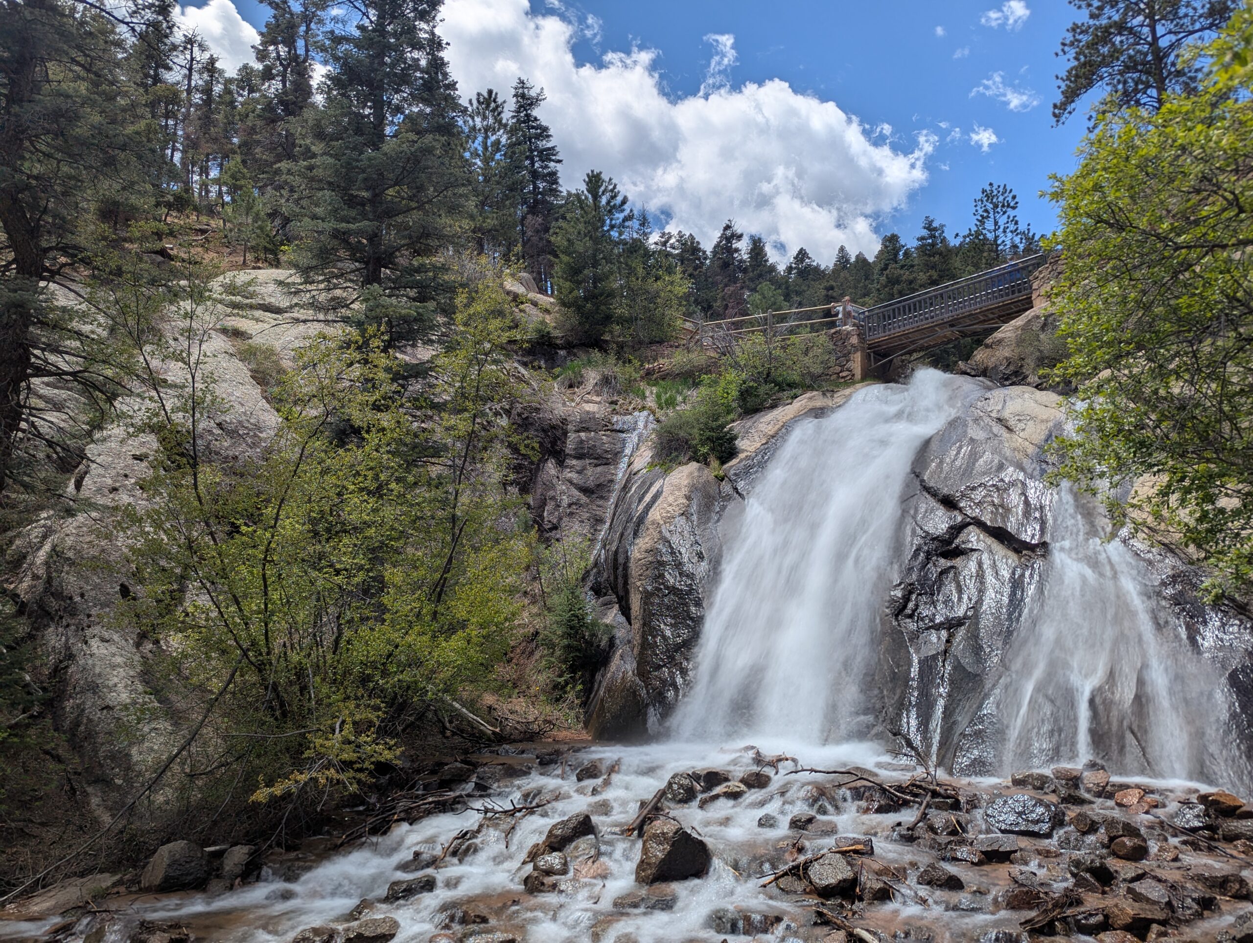
North Cheyenne Cañon Park features over 20 miles of trails for hikers, runners, and mountain bikers, with access to longer backcountry routes extending into surrounding forest lands. Popular destinations include Helen Hunt Falls, one of the most accessible waterfalls in the region, and the Seven Bridges Trail, a scenic route that follows a creek through a shaded canyon.

The park is also home to two key visitor hubs: the Starsmore Visitor and Nature Center, which offers exhibits, educational programs, and trail information, and the Helen Hunt Falls Visitor Center, where visitors can learn about the canyon’s geology, ecology, and history while enjoying views of the falls. The park also connects to Gold Camp Road, a historic corridor offering both recreational access and expansive views.


Wildlife and Scenery

The canyon’s varied terrain supports a wide range of wildlife, including mule deer, black bears, foxes, and numerous bird species. Streams flowing through the canyon create lush riparian zones, while higher elevations transition into dense conifer forests. Seasonal changes bring vibrant wildflowers in spring, cool shaded hikes in summer, golden aspen in fall, and quiet snow-covered landscapes in winter.


History

For generations, Indigenous peoples traveled through this canyon before it became a destination for early settlers and visitors seeking mountain scenery. North Cheyenne Cañon was officially established as a city park in 1885 through land donations by General William Jackson Palmer and others. Over time, the park became a cornerstone of Colorado Springs’ park system, preserving both natural beauty and access to the mountains for the community.


Plan Your Visit

Location: 2120 S. Cheyenne Canyon Rd, Colorado Springs, CO 80906
Parking: Multiple parking areas throughout the canyon, including at trailheads, the Starsmore Visitor and Nature Center, and Helen Hunt Falls
Hours: Open daily, typically 5:00 AM to 9:00 PM (seasonal variations may apply)
Fees: No entry fee

Tips:

  • Stop at the Starsmore Visitor and Nature Center for maps, exhibits, and current trail conditions
  • Visit early, especially on weekends, as parking fills quickly
  • Stay on designated trails to protect sensitive habitat
  • Bring layers—temperatures can vary significantly in the canyon

With its towering canyon walls, flowing waterfalls, and educational visitor centers, North Cheyenne Cañon Park offers a classic Colorado experience just minutes from downtown.

Palmer Park

Palmer Park is one of Colorado Springs’ largest and most beloved urban parks, spanning more than 730 acres in the heart of the city. With rugged bluffs, panoramic overlooks, and miles of trails, the park feels like a wild escape just minutes from downtown.

Trails and Recreation

The park features over 25 miles of multi-use trails for hiking, running, mountain biking, and horseback riding. Popular routes like Yucca, Templeton, and Mesa Trails take visitors through sandstone formations, meadows, and forested ridges. The park also offers a dog park, playgrounds, and athletic fields, making it a favorite destination for families and outdoor adventurers alike.

Amenities and Features

Palmer Park is home to baseball and soccer fields, picnic shelters, restrooms, and wide-open spaces perfect for gatherings. The dog park is among the largest in the city, while Good Neighbors Meeting House (just outside the park) and nearby neighborhoods make it highly accessible. Overlooks such as Grandview Point provide sweeping views of Pikes Peak and the Front Range.

Wildlife & Scenery

From rugged sandstone spires to sweeping grasslands, Palmer Park offers an impressive variety of scenery. Visitors often spot mule deer, coyotes, rabbits, hawks, and songbirds while exploring the trails. Seasonal wildflowers add bursts of color in spring and summer, while the sandstone formations glow at sunrise and sunset.

History

Palmer Park was gifted to the city in 1902 by General William Jackson Palmer, the founder of Colorado Springs, as part of his vision to preserve natural lands for public enjoyment. For over a century, the park has served as both a community gathering space and a wilderness refuge within the city. Its size, history, and rugged beauty make it one of the crown jewels of Colorado Springs’ park system.

Plan Your Visit

Location: 3650 Maizeland Rd, Colorado Springs, CO 80909
Hours: 5:00 a.m. – 9:00 p.m. daily
Parking: Multiple lots located at trailheads, Grandview Overlook, and sports fields.

Ute Valley Park

Ute Valley Park is a rugged, scenic open space tucked into the northwest side of Colorado Springs. Known for its dramatic rock formations, winding trails, and surprisingly wild feel, this park offers a quick escape into nature while remaining easily accessible from surrounding neighborhoods.

Recreation and Trails

Ute Valley Park features a network of interconnected dirt trails popular with hikers, trail runners, and mountain bikers. Routes range from short, rolling loops to steeper climbs with rewarding views, making the park well suited for intermediate users and those looking for a workout close to town. The terrain includes rocky sections, narrow singletrack, and elevation changes that add to the challenge and variety. Trail conditions can change quickly after rain or snow, so checking conditions before heading out is recommended.

Wildlife and Scenery

The park’s mixed landscape of scrub oak, grasslands, and sandstone outcroppings provides habitat for rattlesnakes, mule deer, rabbits, raptors and a variety of songbirds. From higher points along the trail system, visitors are treated to sweeping views of the city, the Front Range, and Pikes Peak. Seasonal changes bring spring wildflowers, golden fall grasses, and striking winter light on the rock formations.

History and Conservation

Ute Valley Park is part of Colorado Springs’ protected open space system and reflects decades of community support for conserving natural landscapes within the urban edge. Ongoing stewardship efforts focus on trail sustainability, erosion control, and balancing recreation with habitat protection to preserve the park’s ecological and recreational value.

Plan Your Visit

Location: Northwest Colorado Springs, near Centennial Boulevard and Fillmore Street
Parking: Small parking areas and neighborhood access points near main trailheads
Hours: Open daily, dawn to dusk
Fees: No entry fee

Tips:

  • Trails are natural surface and can become muddy; avoid use during wet conditions.

  • Expect shared use and yield appropriately to other trail users.

  • Bring water and be prepared for sun and wind exposure.

With its challenging trails, scenic views, and close-to-home convenience, Ute Valley Park is a favorite destination for those seeking a true outdoor experience without leaving the city.

The Manitou Incline is one of the most popular hiking trails in Colorado. The base of the Incline sits at 6,600 feet. It is, perhaps, the most unique and challenging trail in the country, attracting runners, military, Olympic athletes, and hiking enthusiasts from around the world. It is steep, gaining over 2,011 feet of elevation in 0.88 mile. There are approximately 2,750 steps, although the top step is numbered “2768”; the number of steps changes occasionally with trail maintenance and deterioration. While some athletes can conquer the Incline in 30 minutes or less, it takes most people 1-3 hours to make it to the top.  Plus, an additional 1-2 hours to return down the Barr Trail. After you crest the false summit, there are approximately 300 steps to go before reaching the top.

The base of the Incline is located in Manitou Springs near the Cog Railroad. The Inline is free and open to the public, but expect to pay for parking. Even with paid parking, finding a spot can be difficult. In the summer, plan to park in the lot at 10 Old Man’s Trail or in Manitou Springs and take the free shuttle.

PLEASE NOTE: Starting in 2020, users are required to make a FREE reservation online, at coloradosprings.gov/parks/page/manitou-incline.  Pets are NOT allowed on the Incline. Remember to bring plenty of water!! This is an extremely difficult climb at high altitude, and the return route on Barr Trail is about 3 miles, it’s about 4 miles round trip.  You should be in good physical shape and acclimated to Colorado altitude before attempting this trail.

Connections: The Northern Incline Return Trail offers two new return options for hikers, both located in the bottom half of the Incline. The first return is located at railroad tie #395 and the second is at #1300, approximate halfway point. From tie #1300, the trail to return down to the trailhead is roughly 1.5 miles.  From tie #395, it is about a half a mile hike down.  About three-quarters of the way up the Incline, around step #1800 there is a turnoff to the Barr Trail, locally called “The Bailout.” If you don’t have it in you to take on another 1000 steps, this is where you should exit. The top of the Incline also connects to Barr Trail allowing hikers to trek to the summit of Pikes Peak or return to the base of the Incline.

History: Completed in 1907, the Manitou Incline was once a cable tram built to support the construction of a hydroelectric plant and its waterline. After performing this service the railway was then purchased by Dr. Brumbach and turned into a tourist attraction. The Incline boasted a 16-minute ride to “scenic splendors”, 10 miles of hiking trails in Mount Manitou Park, and claimed to be the “longest and highest incline on the globe.” Spencer Penrose bought the Incline in 1923 and made it part of his tourist attraction empire, the cars were upgraded to allow for a retractable roof and more safety. The summit station was again rebuilt in 1958 and lasted until it was dismantled upon closure of the Incline in 1990. A rock slide damaged a section of track in 1990, so the Manitou Springs Incline was closed down. The rails were removed, but the railroad ties remained in the form of a massive staircase.

Nearly 20 years of unmanaged trespass and use of the Incline resulted in significant erosion on the mountainside, dangerous trail conditions, traffic congestion and uncontrolled parking. In 2010, the City of Colorado Springs negotiated pursing legal access to the Incline corridor, and both Colorado Springs and Manitou Springs entered into an Intergovernmental Agreement to plan for formally opening the Incline for public recreation. In 2011, the Manitou Incline Site Development and Management Plan was drafted. After many years of wrangling and an actual Act of Congress, the Incline was made legal in February of 2013.

Volunteer: Contact the Incline Friends to see how you can help, inclinefriends@gmail.com.

Translate »