Mueller State Park
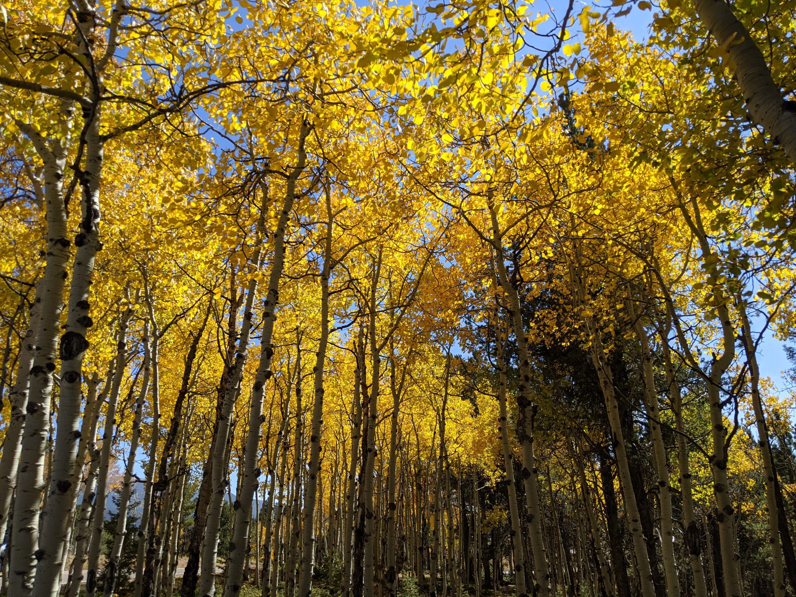
Mueller State Park, located just south of Divide, Colorado, is a 5,000-acre mountain paradise showcasing the best of Colorado’s outdoors. Known for its sweeping views of Pikes Peak, aspen-filled meadows, and dense forests, the park offers year-round recreation for hikers, campers, wildlife enthusiasts, and families seeking adventure.
Recreation and Amenities
The park features more than 50 miles of trails for hiking, mountain biking, and horseback riding. In winter, visitors can enjoy cross-country skiing, snowshoeing, and sledding. Mueller is also a popular camping destination, with over 100 campsites (including RV, tent, and cabins) available, as well as picnic areas and an amphitheater for ranger-led programs.
Wildlife & Scenery
Wildlife is abundant at Mueller, making it a favorite spot for nature lovers. Elk, mule deer, black bears, foxes, coyotes, and a wide variety of birds call the park home. In autumn, golden aspens light up the hillsides, while year-round views of Pikes Peak create a stunning backdrop for outdoor exploration.
History
Once part of a large cattle ranch, Mueller State Park was purchased by the State of Colorado in 1979 and officially opened to the public in 1991. Its establishment was made possible through Great Outdoors Colorado (GOCO) lottery funds, ensuring that this mountain landscape would be preserved and enjoyed by future generations.
Plan Your Visit
Location: 21045 CO-67, Divide, CO 80814
Hours: Open year-round, 5:00 a.m. – 10:00 p.m.
Fees: Daily vehicle entry fee or annual state parks pass required.
Parking: Multiple lots available near trailheads, visitor center, and campground.

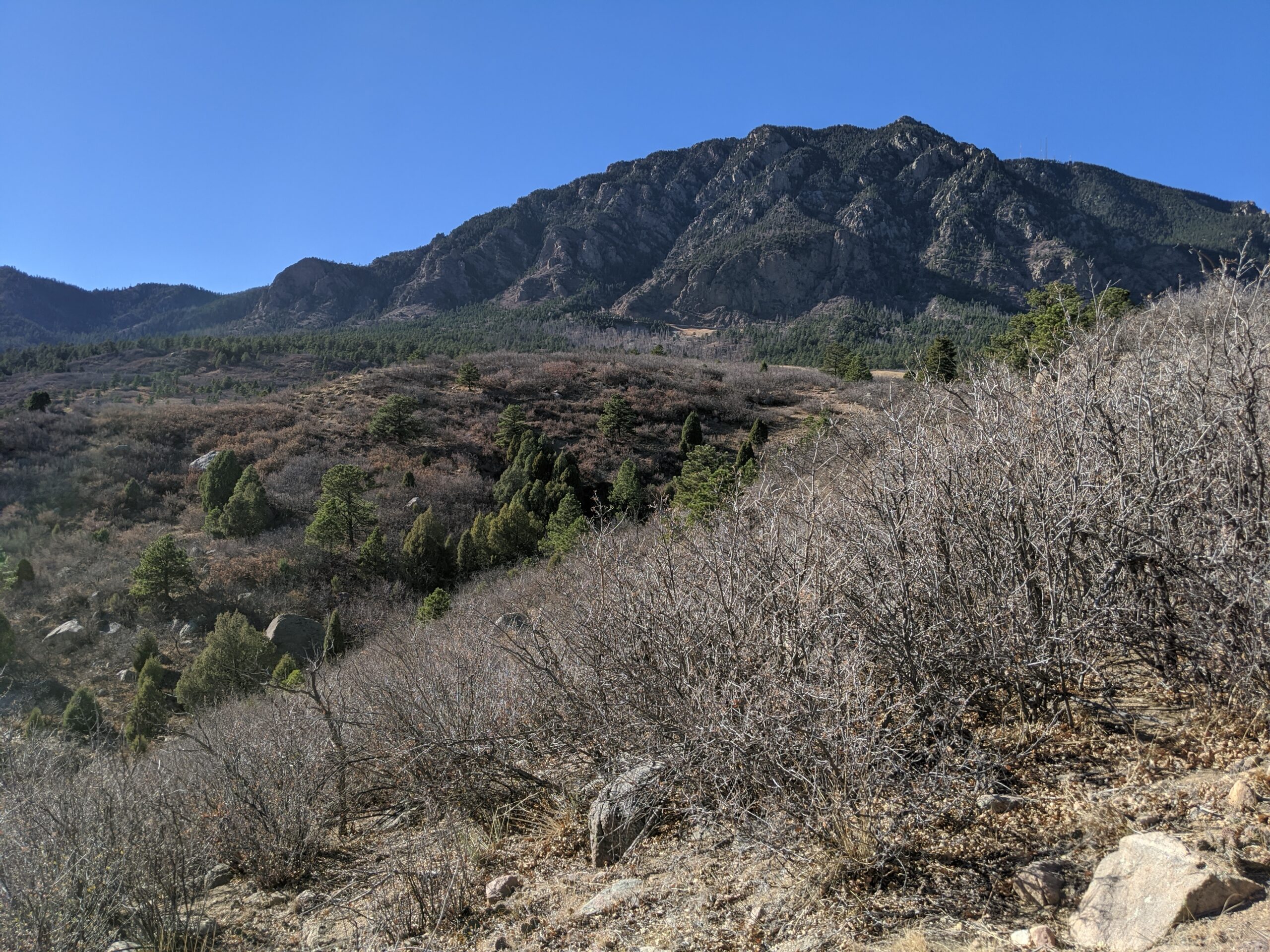
Cheyenne Mountain State Park
Cheyenne Mountain State Park, located at the base of Colorado Springs’ iconic Cheyenne Mountain, is one of the region’s premier outdoor recreation destinations. Spanning over 2,700 acres, this Colorado Parks & Wildlife gem offers diverse wildlife, miles of trails, and one of the best examples of preserved foothill ecosystems along the Front Range.
Trails and Recreation
The park boasts more than 28 miles of trails, open to hikers, trail runners, and mountain bikers. Trails wind through prairie grasslands, scrub oak, and pine forest, offering varied terrain and stunning views of both the city and the mountains. The Dixon Trail, a challenging backcountry route, leads adventurers toward the top of Cheyenne Mountain for an unforgettable vista. The park also features an archery range, picnic areas, and a modern campground with RV hookups, cabins, and tent sites.
Wildlife and Scenery
Cheyenne Mountain State Park is known for its incredible biodiversity. Visitors may spot mule deer, elk, coyotes, black bears, and mountain lions, as well as an abundance of bird species like hawks and bluebirds. Its location at the transition zone between plains and mountains makes it a living classroom for ecology and a scenic retreat for nature lovers.
History
The park opened in 2006 as Colorado’s newest state park, preserving a landscape that had remained largely undeveloped. Named for the Ute word “Shayan,” Cheyenne Mountain has long been a landmark and cultural touchstone for Indigenous peoples, pioneers, and now, outdoor enthusiasts. The park continues to protect natural resources while providing carefully managed access to the public.
Plan Your Visit
-
Location: 410 JL Ranch Heights Road, Colorado Springs, CO 80926
-
Parking: Multiple paved lots are available near trailheads, the visitor center, and the campground. Accessible parking is provided.
-
Hours: Open daily, 5:00 a.m. – 10:00 p.m. The visitor center operates with seasonal hours.
-
Fees: A daily vehicle pass or Colorado State Parks pass is required.
-
Tips: Trails are multi-use, so watch for hikers and bikers. Pets are welcome but must remain leashed. Reservations are recommended for camping.
With its sweeping landscapes, abundant wildlife, and modern amenities, Cheyenne Mountain State Park is the perfect place to hike, camp, and reconnect with nature just minutes from downtown Colorado Springs.
Palmer Park
Palmer Park is one of Colorado Springs’ largest and most beloved urban parks, spanning more than 730 acres in the heart of the city. With rugged bluffs, panoramic overlooks, and miles of trails, the park feels like a wild escape just minutes from downtown.
Trails and Recreation
The park features over 25 miles of multi-use trails for hiking, running, mountain biking, and horseback riding. Popular routes like Yucca, Templeton, and Mesa Trails take visitors through sandstone formations, meadows, and forested ridges. The park also offers a dog park, playgrounds, and athletic fields, making it a favorite destination for families and outdoor adventurers alike.
Amenities and Features
Palmer Park is home to baseball and soccer fields, picnic shelters, restrooms, and wide-open spaces perfect for gatherings. The dog park is among the largest in the city, while Good Neighbors Meeting House (just outside the park) and nearby neighborhoods make it highly accessible. Overlooks such as Grandview Point provide sweeping views of Pikes Peak and the Front Range.
Wildlife & Scenery
From rugged sandstone spires to sweeping grasslands, Palmer Park offers an impressive variety of scenery. Visitors often spot mule deer, coyotes, rabbits, hawks, and songbirds while exploring the trails. Seasonal wildflowers add bursts of color in spring and summer, while the sandstone formations glow at sunrise and sunset.
History
Palmer Park was gifted to the city in 1902 by General William Jackson Palmer, the founder of Colorado Springs, as part of his vision to preserve natural lands for public enjoyment. For over a century, the park has served as both a community gathering space and a wilderness refuge within the city. Its size, history, and rugged beauty make it one of the crown jewels of Colorado Springs’ park system.
Plan Your Visit
Location: 3650 Maizeland Rd, Colorado Springs, CO 80909
Hours: 5:00 a.m. – 9:00 p.m. daily
Parking: Multiple lots located at trailheads, Grandview Overlook, and sports fields.
Colorado Front Range Trail – El Paso County, CO
The Colorado Front Range Trail is a long term vision for a continuous multi use trail system that will one day extend from Wyoming to New Mexico, following the Front Range of Colorado for approximately 876 miles. In El Paso County, this vision is already taking shape through a connected network of regional trails that provide important recreation and transportation opportunities across the Pikes Peak region.
Trail Experience
In El Paso County, the Colorado Front Range Trail consists of roughly 43 continuous miles of multi use trail. The surface varies by segment and includes dirt, gravel, asphalt, and concrete. When traveling south, the route generally follows a gradual downhill slope, making it accessible for a wide range of users.
Because the Front Range Trail is made up of multiple existing trails, it is known by different names depending on location.
Trail Segments
New Santa Fe Regional Trail
The northernmost segment begins in Palmer Lake, north of Monument, and extends approximately 17 miles south through open landscapes and natural areas. This section is primarily gravel, about six feet wide, and is generally straight and level. A critical 6.9 mile portion crosses U.S. Air Force Academy property via a designated trail easement. Visitors must remain on the trail at all times while on Academy land.
Pikes Peak Greenway
Near Woodman Road, the route transitions into the Pikes Peak Greenway, which runs north to south through the heart of Colorado Springs for approximately 16 miles. This largely paved corridor follows Monument Creek and Fountain Creek alongside I 25 and serves as the spine of the city’s urban trail system. Investments from Great Outdoors Colorado and the Trails Open Space Coalition TOPS program helped create an eight foot wide concrete commuter trail between Monument Valley Park and Highway 24. The Greenway connects to dozens of east west trails and passes near popular destinations such as Pikeview Reservoir, Monument Valley Park, America the Beautiful Park, and El Pomar Youth Sports Park.
Fountain Creek Regional Trail
South of El Pomar Youth Sports Park, the trail becomes the Fountain Creek Regional Trail. This segment follows Fountain Creek south toward Fountain Creek Regional Park, terminating near Bandley Drive. The trail is approximately 10 miles long, with an additional three mile disconnected segment within Clear Springs Ranch Open Space. This section features a dirt surface and more elevation changes than the northern segments.
History
The foundation of the Front Range Trail in El Paso County began in April 1982 with the formal opening of the New Santa Fe Regional Trail, which originally extended from Palmer Lake to the U.S. Air Force Academy. In 2013, a generous donation from REI Colorado Springs supported a partnership between the Trails and Open Space Coalition, the City of Colorado Springs, the Greenway Fund, and Leadership Pikes Peak to establish 15 adopter groups along the Pikes Peak Greenway, strengthening long term stewardship and community involvement.
Plan Your Visit
Location: Palmer Lake to Fountain, following the Front Range through El Paso County
Length: Approximately 43 continuous miles
Surface: Gravel, dirt, asphalt, and concrete depending on segment
Amenities: Multiple trailheads, connections to local parks and neighborhoods
Tips: Stay on designated trails, especially on U.S. Air Force Academy property. Check segment specific conditions before heading out.
The Colorado Front Range Trail in El Paso County represents decades of collaboration, investment, and community stewardship. As connections continue to improve, this regional corridor will play an increasingly important role in linking communities, supporting active transportation, and expanding access to outdoor recreation across the Pikes Peak region.