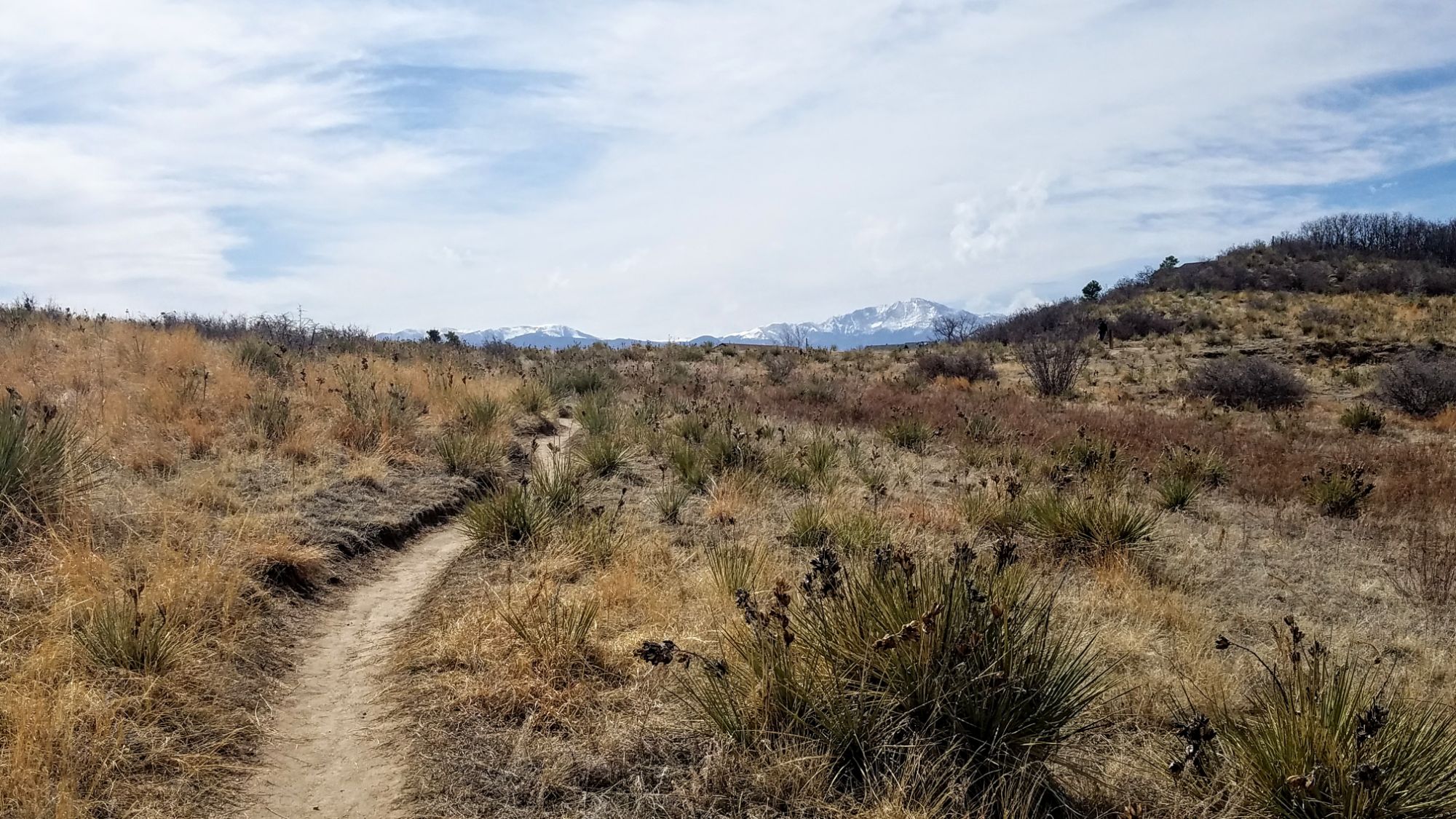
Palmer Park is one of Colorado Springs’ largest and most beloved urban parks, spanning more than 730 acres in the heart of the city. With rugged bluffs, panoramic overlooks, and miles of trails, the park feels like a wild escape just minutes from downtown.
Trails and Recreation
The park features over 25 miles of multi-use trails for hiking, running, mountain biking, and horseback riding. Popular routes like Yucca, Templeton, and Mesa Trails take visitors through sandstone formations, meadows, and forested ridges. The park also offers a dog park, playgrounds, and athletic fields, making it a favorite destination for families and outdoor adventurers alike.
Amenities and Features
Palmer Park is home to baseball and soccer fields, picnic shelters, restrooms, and wide-open spaces perfect for gatherings. The dog park is among the largest in the city, while Good Neighbors Meeting House (just outside the park) and nearby neighborhoods make it highly accessible. Overlooks such as Grandview Point provide sweeping views of Pikes Peak and the Front Range.
Wildlife & Scenery
From rugged sandstone spires to sweeping grasslands, Palmer Park offers an impressive variety of scenery. Visitors often spot mule deer, coyotes, rabbits, hawks, and songbirds while exploring the trails. Seasonal wildflowers add bursts of color in spring and summer, while the sandstone formations glow at sunrise and sunset.
History
Palmer Park was gifted to the city in 1902 by General William Jackson Palmer, the founder of Colorado Springs, as part of his vision to preserve natural lands for public enjoyment. For over a century, the park has served as both a community gathering space and a wilderness refuge within the city. Its size, history, and rugged beauty make it one of the crown jewels of Colorado Springs’ park system.
Plan Your Visit
Location: 3650 Maizeland Rd, Colorado Springs, CO 80909 Hours: 5:00 a.m. – 9:00 p.m. daily Parking: Multiple lots located at trailheads, Grandview Overlook, and sports fields.
Stratton Open Space
Located in southwest Colorado Springs, Stratton Open Space is a diverse and well loved natural area bordering North Cheyenne Cañon Park. With miles of trails, multiple ecosystems, and direct access toward Pike National Forest, Stratton offers a rich outdoor experience that blends recreation, wildlife habitat, and long standing community conservation.
Recreation and Trails
Stratton Open Space features approximately 15 miles of trails spread across 318 acres, making it a popular destination for hikers and mountain bikers. The trail network winds through foothills terrain, forested slopes, and open ridgelines, offering a range of experiences from moderate climbs to flowing descents.
Several trails have specific designations that visitors should note. The Chutes is a downhill bicycle only trail. The Ladders is a multi use, multi directional trail that provides an important connection between Chamberlain Trail and Gold Camp Road. The Gold Camp Path is a bi directional trail designated for hiking only. Clear signage helps guide users through the system and supports safe, shared use of the trails.
Stratton’s western edge connects seamlessly into North Cheyenne Cañon Park, allowing visitors to link outings across a much larger protected landscape.
Wildlife and Scenery
Stratton Open Space supports a wide variety of wildlife thanks to its range of habitats. Mule deer are commonly seen, along with coyote, black bear, mountain lion, gray fox, and bobcat. Smaller mammals such as rabbits, chipmunks, and squirrels are abundant, and the area supports a diverse bird population year round.
Reptiles found in Stratton include fence lizards, garter snakes, bullsnakes and rarely rattlesnakes. Visitors are encouraged to remain aware of their surroundings and respect wildlife at all times.
History
Efforts to protect Stratton Open Space began in the early 1990s, driven by local citizens who recognized the value of preserving this landscape. In 1998, the City of Colorado Springs purchased the property for $5.9 million. Most of the funding came from the Trails, Open Space, and Parks sales tax, with additional support from Great Outdoors Colorado, private donations, and The Trust for Public Land.
A conservation easement was placed on the property as part of the Great Outdoors Colorado funding and is held by Palmer Land Trust. Stratton Open Space is owned by the City of Colorado Springs and managed by the Parks, Recreation, and Cultural Services Department. Adjacent land managed by Colorado Springs Utilities includes water supply reservoirs and blends seamlessly with the open space outside of fenced infrastructure areas.
Plan Your Visit
Location: Southwest Colorado Springs, adjacent to North Cheyenne Cañon Park Parking: Available at multiple access points and nearby trailheads Hours: Open daily, dawn to dusk Fees: No entry fee
Tips:
Follow posted trail designations, especially on bike only and hiking only routes
Watch for wildlife and maintain safe distances
Trails can be icy or muddy depending on season and weather
Supported by the Friends of Stratton Open Space, this area reflects decades of community commitment to conservation and recreation. Stratton Open Space remains a cornerstone of Colorado Springs’ open space system, offering connected trails, rich habitat, and access to some of the region’s most iconic landscapes.
Kane Ranch Open Space
Located east of Fountain, Kane Ranch Open Space is a 440-acre landscape of native grasslands, cottonwood groves, and expansive plains views. The property offers wide-open scenery with distinctive views of Pikes Peak and Cheyenne Mountain and supports a growing regional trail network. As one of El Paso County’s newest open spaces, Kane Ranch blends outdoor recreation with cultural and historical significance.
Recreation and Trails
Kane Ranch Open Space features the Lariat Loop Trail, a natural-surface loop approximately 3.5 miles in length. The trail is suitable for hiking, running, bicycling, and equestrian use, with sufficient width to accommodate two riders on horseback side by side.
A designated trailhead includes equestrian parking, a turnaround loop, a portable restroom enclosure, and interpretive signage. Additional trails are planned and will provide future connections to regional routes, including the Black Squirrel Creek Trail and Kane Ranch Trail.
Wildlife and Scenery
The open space supports grassland and riparian habitats that provide shelter for a variety of wildlife species. Visitors may encounter reptiles, small mammals, and grassland birds throughout the property.
Rattlesnakes are present in the area, and visitors are encouraged to remain on designated trails and keep dogs on leash. Goat head thorns are also prevalent, and appropriate footwear is recommended.
History
Kane Ranch Open Space opened to the public on March 23, 2022, following its acquisition by El Paso County in 2003 through the estate of former rancher Alexander F. Kane. The land was once part of a 5,000-acre ranch established in the 1940s by Wanden Matthews La Farge, who later married Alexander “Andy” Kane. Wanden Kane served two terms as mayor of Fountain and was Colorado’s first female mayor.
The ranch later became a successful quarter-horse operation and the foundation for the Kane Family Foundation, which supports merit-based scholarships for students in southern Colorado. Wanden’s son, Oliver Albee “Pete” La Farge, was a noted musician, writer, and artist whose work included songs recorded by Johnny Cash. He is buried in the Kane Family Cemetery, now preserved within the open space.
Plan Your Visit
Location: East of Fountain, El Paso County Parking: Trailhead with equestrian parking and turnaround loop Hours: Open daily, dawn to dusk Fees: No entry fee
Tips
Stay on designated trails and keep dogs on leash due to rattlesnakes
Watch for goat head thorns and wear appropriate footwear
Yield appropriately to equestrians and other trail users
Bring water and sun protection, as shade is limited
BEWARE OF RATTLESNAKES
Kane Ranch Open Space reflects El Paso County’s commitment to preserving working landscapes, cultural history, and accessible outdoor recreation. With expanding trail connections and wide-open scenery, the property offers visitors a distinctive plains-to-mountains open space experience.
High Chaparral Open Space is 54 acres on the eastern side of Colorado Springs, characterized by a prominent ridgeline vegetated with scrub oak, shrubland patches and mixed-grass prairie. Views from the crest of the ridge, the highest point in eastern Colorado Springs, include the Spanish Peaks and Wet Mountains to the south, the Black Forest to the north, and an uninterrupted view of Colorado Springs mountain backdrop to the west. High Chaparral Open Space provides wildlife habitat, recreational opportunities, and a visual buffer to a fast-growing section of the City.
Figure 8 trail system is about 2 miles. Preview the area and see why people love to walk, ride and bird watch at High Chaparral! Parking lot at Stetson Hills also provides great access to Homestead Trail.
Bluestem Prairie Open Space offers 646 acres of prairie grassland and bird watching paradise. Home to over 200 bird species and several mammal species, Bluestem Prairie Open Space has become a refuge for a variety of native wildlife and vegetation. Roughly 9 miles of flowing, dirt single track trail make it an ideal location for beginner mountain bikers. The area has no shade, bring plenty of water if you visit in the summer, we recommend visiting early in the morning or evening.
NOTE: No dogs allowed, due to native wildlife.
History: Located just south of the Colorado Springs Municipal Airport, this land once belonged to the Banning-Lewis Ranch. Here ranchers relied primarily on rich soils and thriving grasslands to survive. This land remains home to varied mammals such as the Pronghorn, the Black-tailed prairie dog and birds like the Red-tailed hawk, Burrowing owls and Migratory Shorebirds.
In the fall of 2000, the Trust for Public Land purchased the Big Johnson property from Cygnet Land, LLC and then conveyed the property to the City of Colorado Springs. The City used funds from its Trails, Open Space, and Parks (TOPS) sales tax and a grant from Great Outdoors Colorado (GOCO) to acquire the property. View BIG JOHNSON OPEN SPACE MASTER PLAN.
The namesake “bluestem” highlights the tallgrass species found in northwest portion of the property, while the more predominant shortgrass community in the bowl-shaped valley surrounds the privately-owned Big Johnson Reservoir. The Bluestem Prairie Open Space Management Plan was adopted by the Park and Recreation Advisory Board on March 10, 2016.
Located on the northwest side of Colorado Springs, Blodgett Open Space is a rugged foothills landscape that protects critical wildlife habitat, scenic views, and long term trail connectivity between the city and adjacent public lands. The open space is managed to balance conservation with carefully planned recreation in a challenging and ecologically sensitive environment.
Recreation and Access
Blodgett Open Space offers a steep, backcountry style experience close to the city and is best suited for experienced hikers, trail runners, and mountain users. Trails climb quickly through foothills terrain and are often rocky, narrow, and physically demanding. Elevation gain is significant, and trail conditions can vary widely depending on weather and season.
Trail access is provided through designated trailheads, and users are expected to remain on approved routes. Due to the steep terrain and sensitive resources, Blodgett Open Space is not intended for casual use, and visitors should be prepared for changing conditions and limited amenities.
Landscape and Wildlife
Blodgett Open Space supports a diverse mix of foothills ecosystems, including grasslands, scrub oak, and ponderosa pine forest. The area provides important habitat and movement corridors for mule deer, black bear, mountain lion, and a wide variety of bird species.
The landscape includes steep slopes, drainage corridors, and prominent ridgelines that offer expansive views of Colorado Springs and the eastern plains. These natural features contribute to both the ecological value of the open space and the challenging nature of recreation in the area.
History and Conservation
Blodgett Open Space consists of multiple parcels acquired by the City of Colorado Springs through the Trails, Open Space, and Parks (TOPS) program over more than two decades. Together, these acquisitions total 384 acres of protected open space.
The original Blodgett Open Space parcel was purchased in 2001 using TOPS funds and includes 167 acres with a designated trailhead along Woodmen Road. This parcel was master planned in 2003 and later guided by a forest management plan adopted in 2006.
In 2018, the City acquired an additional 64 acres known as the South Blodgett property. This parcel includes previously constructed access roads, designated trails, and areas impacted by user created trails. The property is protected by three conservation easements held by El Paso County, preserving scenic, open space, trail connection, wildlife, and ecological values. An interim use plan was developed in 2019 to allow public access while long term planning continued.
Between 2020 and 2021, the City expanded Blodgett Open Space through the acquisition of 153 additional acres known as the Pikeview frontage property. This land lies south of the original open space and west of the Oak Valley neighborhood. Portions of the property reflect historic disturbance associated with stormwater facilities and adjacent quarry operations, and include areas subject to reclamation requirements. These parcels strengthen regional connectivity while supporting long term restoration and conservation goals.
Additional dedicated open space parcels include the 5 acre Peregrine Open Space near the North Blodgett Trailhead and the nearly 10 acre Oak Valley Ranch Open Space along the North Douglas Creek corridor. Together, these lands provide important ecological connections, protect drainageways, and support future trail and habitat planning.
Plan Your Visit
Location: Northwest Colorado Springs, near Woodmen Road and Centennial Boulevard Parking: Limited parking at designated trailheads Hours: Open daily, dawn to dusk Fees: No entry fee
Tips:
Be prepared for steep terrain and limited amenities
Stay on designated trails to protect sensitive resources
Carry adequate water and plan for changing weather
Blodgett Open Space reflects a long term community investment in conserving Colorado Springs’ foothills landscapes. Through thoughtful acquisition, conservation easements, and ongoing management planning, the open space protects critical natural resources while allowing for carefully managed recreation close to the city.
Austin Bluffs Open Space – Colorado Springs, CO
Austin Bluffs Open Space is a rugged and scenic natural area on the northeast side of Colorado Springs, known for its dramatic rock formations, sweeping city views, and strong sense of wildness within an urban setting. Rising above surrounding neighborhoods, this open space offers a quieter, more contemplative outdoor experience while playing an important role in habitat protection and community access to nature.
One of the most recognizable landmarks within Austin Bluffs Open Space is Pulpit Rock, a striking volcanic rock formation that has become a local icon and viewpoint.
Trails and Recreation
Austin Bluffs Open Space features a network of informal and designated trails that wind through grasslands, rocky outcrops, and rolling terrain. These trails are popular for hiking, trail running, and short neighborhood outings, offering expansive views of Colorado Springs and the Front Range.
A primary destination within the open space is Pulpit Rock, where visitors are rewarded with panoramic views after a steady climb. The terrain varies from gradual paths to steeper, rocky sections near the rock formations, making it accessible to a range of users while still feeling adventurous. Because of the sensitive landscape, visitors are encouraged to stay on established trails to reduce erosion and protect habitat.
Geology and Landscape
Austin Bluffs Open Space is defined by its unique volcanic geology, with rock formations like Pulpit Rock standing out dramatically against the surrounding grasslands. These features offer insight into the region’s geologic past while creating natural landmarks that shape the character of the open space.
The elevated bluffs provide sweeping views across the city, Garden of the Gods, and toward Pikes Peak, making the area especially popular at sunrise and sunset.
Wildlife and Habitat
The open space supports native plant communities and provides important habitat for urban wildlife. Visitors may encounter mule deer, foxes, rabbits, hawks, and a variety of songbirds. Native grasses and seasonal wildflowers contribute to both ecological health and scenic beauty.
As development continues around the area, Austin Bluffs Open Space serves as a critical refuge for wildlife and a reminder of the importance of conserving natural landscapes within city limits.
Stewardship and Conservation
Austin Bluffs Open Space is managed with an emphasis on balancing recreation and conservation. Stewardship efforts focus on trail management, erosion control, habitat protection, and community education. Public involvement and responsible use are essential to maintaining the health and accessibility of the area.
Ongoing planning and community engagement help guide how Austin Bluffs is protected and enjoyed today and into the future.
Plan Your Visit
Location: Northeast Colorado Springs, near Austin Bluffs Parkway and surrounding neighborhoods Access: Multiple neighborhood access points lead into the open space Parking: Limited roadside and neighborhood parking near trail access points Hours: Open daily, dawn to dusk More Information: https://coloradosprings.gov/austinbluffsopenspace
Tips:
Stay on designated trails, especially near Pulpit Rock
Bring water and sun protection—shade is limited
Pack out all trash and respect wildlife
Expect uneven and rocky terrain in some areas
Austin Bluffs Open Space, anchored by the iconic Pulpit Rock, offers a rare blend of wild landscape, scenic views, and everyday access to nature—making it an essential part of Colorado Springs’ open space system.
Templeton Gap Trail – Colorado Springs, CO
Templeton Gap Trail is an important east west multi use trail in central Colorado Springs that follows the Templeton Gap Floodway. The trail provides a key connection between neighborhoods, parks, open spaces, and several major trail corridors, making it a popular route for both recreation and transportation.
Trail Experience
Templeton Gap Trail is approximately 4 miles long and runs primarily east to west alongside the Templeton Gap Floodway. The trail begins near Mark Dabling Boulevard at the Goose Gossage Youth Sports Complex and continues west to Palmer Park, with a northern fork extending toward Union Meadows Open Space near Austin Bluffs Boulevard and Union Boulevard.
The trail surface is primarily concrete, with some sections of asphalt and gravel. Elevation changes are generally mild, though users should expect a few moderate hills along the route.
Road Crossings and Navigation
Templeton Gap Trail includes several street crossings, including a major crossing at North Nevada Avenue. A short discontinuity exists near North Hancock Avenue by Portal Park. The trail runs on both sides of the floodway; however, to pass under Union Boulevard near Hancock Avenue, it is recommended to remain on the south side of the floodway for a more continuous route.
Connections
Templeton Gap Trail connects directly to the Pikes Peak Greenway at Goose Gossage Youth Sports Complex. From this location, users can also access Sinton Trail to continue west. On the eastern end, the trail links to Austin Bluffs Trail near North Union Boulevard, providing access toward the University of Colorado Colorado Springs campus. Additional connections include Greencrest Trail into Palmer Park and easy access to Union Meadows Open Space.
Cottonwood Creek Trail – Colorado Springs, CO
Cottonwood Creek Trail is a major east west urban trail in northern Colorado Springs and a key connector within the city’s trail system. Following Cottonwood Creek, the trail links neighborhoods, parks, and regional trail corridors while providing a smooth and accessible route for everyday recreation and transportation.
Location: Northern Colorado Springs, following Cottonwood Creek from Powers Boulevard to the Pikes Peak Greenway near I 25
Trail Experience
Cottonwood Creek Trail is just over 6 miles long and features a smooth concrete surface throughout. The trail runs east to west along Cottonwood Creek, beginning near Frank Castello Park at Powers Boulevard and continuing west to connect with the Pikes Peak Greenway and Front Range Trail near I 25.
The trail is generally flat with gentle elevation changes, making it accessible for walkers, runners, cyclists, families, and users of mobility devices. The corridor offers a mix of riparian habitat, open space, and neighborhood views, with long straight segments that are well suited for longer outings or commuting. Benches, trail access points, and nearby amenities allow users to easily tailor trips to their preferred distance and pace.
A dirt trail alternative runs between Union Boulevard and Rangewood Drive, providing a more natural surface option and forming a pleasant 3 mile loop with convenient parking at Cottonwood Creek Community Park.
Road Crossings and Navigation
Cottonwood Creek Trail includes one major street crossing at Union Boulevard. Trail users should use the marked crosswalk at Woodland Hills Drive when crossing Union Boulevard. The trail passes alongside Frank Castello Park and includes a spur connection to Dublin Park; however, accessing Dublin Park requires crossing Dublin Boulevard, which currently does not have a designated pedestrian crossing.
Connections
Cottonwood Creek Trail connects directly to the Pikes Peak Greenway and Front Range Trail just south of the Woodmen Road and Rockrimmon Boulevard area. Multiple neighborhood access points provide easy connections to Cottonwood Creek Community Park, nearby residential areas, and the YMCA. The trail also links to Woodmen Trail and other local trail segments, strengthening north south and east west connectivity across northern Colorado Springs.
Skyline Trail – Colorado Springs, CO
Skyline Trail is a neighborhood focused urban trail in northern Colorado Springs that provides an important north south connection through the Briargate area. Often referred to locally as the Powerline Trail due to its alignment with overhead powerlines, Skyline Trail is well used by nearby residents for walking, running, and biking.
Skyline Trail is approximately 2 miles long and features a mix of wide concrete and dirt trail surfaces. South of Research Parkway, the trail is smooth concrete, while the segment north of Research Parkway transitions to a dirt surface. Rolling terrain creates noticeable elevation gain and loss, giving the trail a moderate difficulty rating.
The trail includes several distinctive switchbacks near Mirage Drive that offer views across the surrounding neighborhoods and open spaces. Despite its urban setting, the corridor provides a sense of separation from nearby roads and is popular for short neighborhood outings as well as longer connected trips.
Road Crossings and Navigation
Skyline Trail includes several street crossings and users should proceed with caution at all crosswalks. Major crossings occur at Briargate Boulevard and Research Parkway. When crossing Research Parkway, users should use the signalized intersection at Chapel Hills Drive for improved safety. Trail signage varies by segment, and awareness is recommended when navigating transitions between surfaces.
Connections
Skyline Trail transitions into Woodmen Trail at Briargate Boulevard, allowing users to continue east west through northern Colorado Springs. A spur trail provides access to Rampart Community Park, which includes a disc golf course, sports courts and fields, and a dog park. The trail passes near High Plains Elementary School and offers views of Reflection Pond, which can be accessed via sidewalks on Parliament Drive.
Sidewalk connections along Briargate Parkway allow access to John Venezia Community Park and the Briargate Trail. Multiple neighborhood access points along the route make Skyline Trail easy to reach from surrounding residential areas.
Skyline Trail plays an important role in connecting neighborhoods, parks, and trails across northern Colorado Springs while offering a moderately challenging route with varied terrain and strong local use.