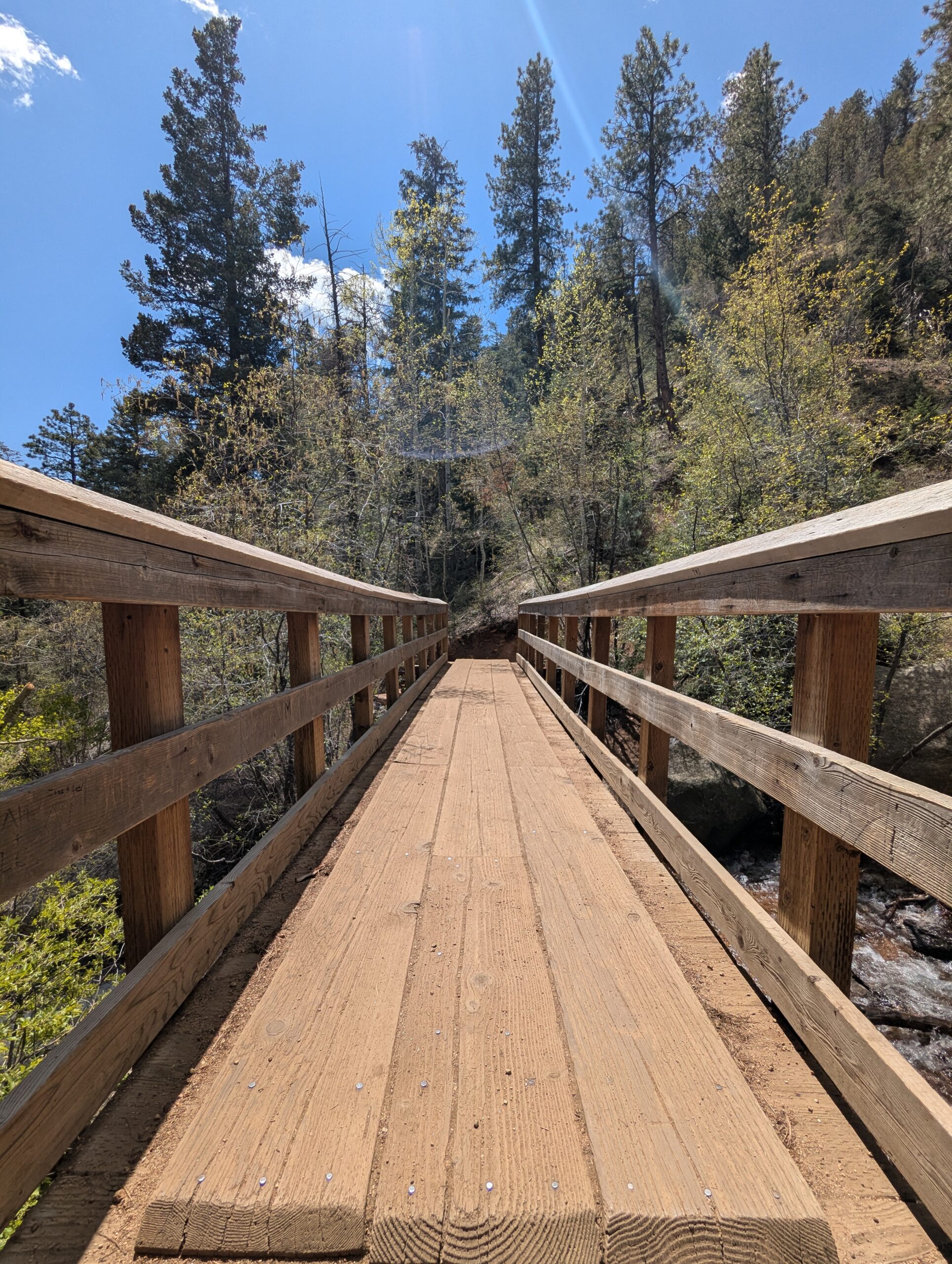
Seven Bridges Trail (#622)

The Seven Bridges Trail, also known as Trail #622, is one of the most popular hikes in North Cheyenne Cañon. This moderate trail is about 3.7 miles round trip and gains roughly 1,000 feet in elevation as it follows North Cheyenne Creek. Its charm comes from crossing seven rustic wooden bridges that give the trail its name, making it a family-friendly adventure with plenty of photo opportunities.

Trails and Recreation

The trail begins at the end of North Cheyenne Canyon Road near the parking area for the Upper Gold Camp Road. From there, hikers follow a steady incline along a shaded canyon trail, crossing over seven picturesque wooden bridges. Beyond the seventh bridge, the path continues into steeper terrain and can be extended to connect with higher trails like Jones Park or Mount Rosa for those looking for a longer trek.

Wildlife and Scenery

Surrounded by towering evergreens, mountain streams, and granite walls, the Seven Bridges Trail offers classic Front Range beauty. Depending on the season, hikers may encounter wildflowers, colorful autumn foliage, or sparkling ice formations along the creek. Wildlife is common in the area—mule deer, songbirds, and the occasional black bear may be spotted in the canyon.

History

The trail follows an old pipeline route that once carried water from the mountains into Colorado Springs in the early 20th century. The bridges were originally constructed to maintain access along the pipeline, and today they remain a beloved feature of this historic route.

Plan Your Visit

Location: Trailhead parking is located at the end of North Cheyenne Canyon Road, just past the closed Gold Camp Road tunnel.
Parking: A paved lot is available, but it fills quickly—arrive early, especially on weekends. Additional parking may be available further down the road.
Hours: Open daily, 5:00 a.m. – 9:00 p.m.
Tips:

  • The trail is well-shaded, making it a great summer hike.

  • Dogs are welcome but must be leashed.

  • Wear sturdy shoes, as the path can be rocky and icy in colder months.

  • Continue past the seventh bridge if you want to extend your hike into the higher country of Pike National Forest.

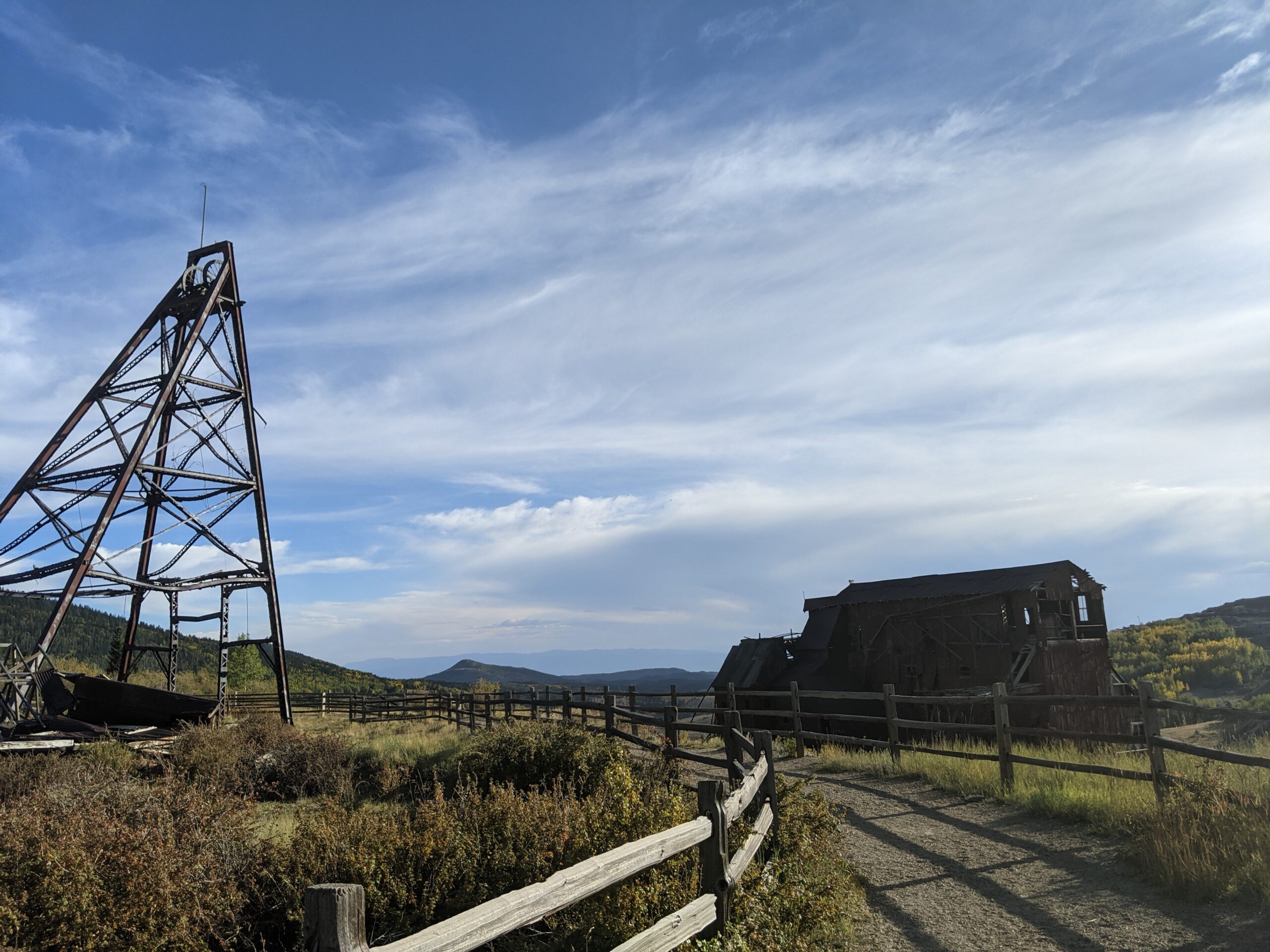
Vindicator Valley Trail

Vindicator Valley Trail in Victor, Colorado, offers a fascinating blend of outdoor recreation, mining history, and scenic beauty in the heart of the Cripple Creek & Victor Mining District. This interpretive loop trail winds through historic mining structures and reclaimed landscapes, giving visitors a glimpse into Colorado’s Gold Rush era while showcasing views of Pikes Peak and the rugged hills of Teller County.

Trails and Recreation

The Vindicator Valley Trail is a 2-mile loop that is rated easy to moderate, making it accessible for most hikers, families, and history enthusiasts. Along the way, you’ll find interpretive signs explaining the mining operations, equipment, and the lives of the people who once worked the area. The trail is popular year-round for hiking, snowshoeing, and photography.

Wildlife and Scenery

While the mining remnants are the highlight, the surrounding landscape is equally striking. Wildflowers bloom in summer, while fall brings golden aspens and crisp mountain air. Mule deer, elk, foxes, and a variety of bird species can often be spotted along the trail. Panoramic views of the Sangre de Cristo and Sawatch mountain ranges add to the experience.

History

Vindicator Valley sits in the heart of the Cripple Creek & Victor Gold Mining District, one of the most productive gold mining areas in the United States during the late 1800s and early 1900s. The trail passes by the historic Vindicator Mine and other structures that once fueled Colorado’s mining boom. Many of these wooden headframes and buildings have been stabilized to preserve them as open-air museums, allowing visitors to connect directly with the region’s past.

Plan Your Visit

Location: Trailhead located just north of Victor, CO off County Road 831 (about 45 minutes west of Colorado Springs).
Parking: A gravel lot is available at the trailhead. Parking is free but limited.
Hours: Open daily, year-round, from dawn to dusk.
Tips:

  • Interpretive signage is plentiful—allow time to read and explore.

  • Bring water and sun protection; shade is limited.

  • Winter visits may require traction devices or snowshoes.

  • Respect historic structures by staying on designated trails.

Rock Island Trail – Colorado Springs, CO

The Rock Island Trail in Colorado Springs follows a historic railroad corridor through the heart of the city, providing an easy, accessible east west route that connects neighborhoods, parks, and major trail systems. Built along the former Rock Island Railroad bed, the trail reflects the city’s transportation history while serving modern recreation and commuting needs.


Location: Central Colorado Springs, running east west alongside Constitution Avenue from Weber Street to Powers Boulevard


Trail Experience

The Colorado Springs segment of the Rock Island Trail is approximately 6 miles long. It runs east west from Weber Street to Powers Boulevard, generally paralleling Constitution Avenue. The trail surface is a mix of concrete and asphalt, creating a smooth and accessible experience for walking, biking, and other non motorized uses.

The trail has a gentle grade, with a gradual uphill slope when traveling east. Several at grade street crossings occur along the route, so users should exercise caution at intersections. The corridor passes through residential areas and urban landscapes, offering a practical and well used route for everyday recreation and transportation.


Connections

Rock Island Trail connects directly to the Shooks Run Trail, creating a continuous north south and east west trail link through the city. With limited street or sidewalk travel, users can also connect to the Pikes Peak Greenway, Homestead Trail, and Palmer Park, making this trail an important part of Colorado Springs’ broader urban trail network.

The Homestead Trail is about 7 miles in length, with a couple disconnects. The northern segment is about 2 miles long, it feeds off of the Cottonwood Creek Trail heading southeast, ending abruptly at Templeton Gap Rd, from there users can travel by sidewalk to the southern segment which begins at the High Chaparral Open Space Parking lot off Stetson Hills Blvd (accessible only when driving east on Stetson Hills).

This is the more commonly known portion of the Homestead Trail. It stretches for 5 miles, encountering several major street crossings and a handful of neighborhood parks. The Homestead Trail is not an easy ride, it has rolling hills and the trail surface ranges from dirt to concrete, but it is mostly asphalt (some sections are very rough and deteriorated).  Homestead trail terminates at Radiant Dr.

This trail is managed by City of Colorado Springs Parks, Recreation and Cultural Services: (719) 385-5940.  For more info visit coloradosprings.gov/parks.

Connections: Homestead Trail connects to Cottonwood Creek Trail, about a mile south of Woodmen Rd. The trail travels though or next to several parks including Old Farm, Rudy, Homestead, Villa Loma and Penrose. With some street/sidewalk use it is possible to access Palmer Park and the Rock Island Trail. Homestead share a trailhead/parking lot with High Chaparral Open Space.

Future Plans: Eventually Homestead Trail should connect to the Rock Island Trail. The gap between Templeton Rd and Stetson Hills Blvd will be connected with a new trail segment. View COS Park System Master Plan, which includes trail networks.

The Foothills Trail spans approximately 6.5 miles and plays a crucial role in connecting the west side of Colorado Springs. Running primarily in a north/south direction parallel to Flying W Ranch Rd and 30th Street, the trail commences in the north near Oak Valley Ranch Park, following south along an irrigation channel (Flying Ranch Rd). At Garden of the Gods, a small spur connects to the Sinton Trail, while the main trail continues along 30th Street.

Upon reaching Chambers Way (near Garden of the Gods Dog Park), the trail transitions into a sidewalk along 31st. Its southern terminus is at Colorado Blvd. The surface along 30th is smooth concrete, whereas along Flying Ranch Rd, the trail is mostly dirt with occasional pavement sections. There are several street crossings.
In general, the trail offers a moderate experience with rolling hills and breathtaking views. Managed by the City of Colorado Springs Parks, Recreation, and Cultural Services, inquiries can be directed to (719) 385-5940. For additional information, visit coloradosprings.gov/UrbanTrails.

Connections: The Foothills Trail links with the Sinton Trail on Garden of the Gods Rd. At the southern end, it connects to sidewalks and bike lanes on 31st St, leading to Red Rock Canyon Open Space on the opposite side of Hwy 24. The trail traverses Mountain Shadows Park, Blair Bridge Open Space, passes under N 30th St, skirts the edge of Garden of the Gods Park and its dog park, providing convenient access to the Garden for the Pleasant Valley neighborhood. On the east side of 30th St, it connects to the Palmer-Mesa Trail.

Future Plans: As part of the Camp Creek drainage reconfiguration down the center of 31st, a multi-use path will be added, connecting to the Foothills Trail. Refer to the COS Park System Master Plan for additional details, including trail networks.

Colorado Front Range Trail – El Paso County, CO

The Colorado Front Range Trail is a long term vision for a continuous multi use trail system that will one day extend from Wyoming to New Mexico, following the Front Range of Colorado for approximately 876 miles. In El Paso County, this vision is already taking shape through a connected network of regional trails that provide important recreation and transportation opportunities across the Pikes Peak region.


Trail Experience

In El Paso County, the Colorado Front Range Trail consists of roughly 43 continuous miles of multi use trail. The surface varies by segment and includes dirt, gravel, asphalt, and concrete. When traveling south, the route generally follows a gradual downhill slope, making it accessible for a wide range of users.

Because the Front Range Trail is made up of multiple existing trails, it is known by different names depending on location.


Trail Segments

New Santa Fe Regional Trail
The northernmost segment begins in Palmer Lake, north of Monument, and extends approximately 17 miles south through open landscapes and natural areas. This section is primarily gravel, about six feet wide, and is generally straight and level. A critical 6.9 mile portion crosses U.S. Air Force Academy property via a designated trail easement. Visitors must remain on the trail at all times while on Academy land.

Pikes Peak Greenway
Near Woodman Road, the route transitions into the Pikes Peak Greenway, which runs north to south through the heart of Colorado Springs for approximately 16 miles. This largely paved corridor follows Monument Creek and Fountain Creek alongside I 25 and serves as the spine of the city’s urban trail system. Investments from Great Outdoors Colorado and the Trails Open Space Coalition TOPS program helped create an eight foot wide concrete commuter trail between Monument Valley Park and Highway 24. The Greenway connects to dozens of east west trails and passes near popular destinations such as Pikeview Reservoir, Monument Valley Park, America the Beautiful Park, and El Pomar Youth Sports Park.

Fountain Creek Regional Trail
South of El Pomar Youth Sports Park, the trail becomes the Fountain Creek Regional Trail. This segment follows Fountain Creek south toward Fountain Creek Regional Park, terminating near Bandley Drive. The trail is approximately 10 miles long, with an additional three mile disconnected segment within Clear Springs Ranch Open Space. This section features a dirt surface and more elevation changes than the northern segments.


History

The foundation of the Front Range Trail in El Paso County began in April 1982 with the formal opening of the New Santa Fe Regional Trail, which originally extended from Palmer Lake to the U.S. Air Force Academy. In 2013, a generous donation from REI Colorado Springs supported a partnership between the Trails and Open Space Coalition, the City of Colorado Springs, the Greenway Fund, and Leadership Pikes Peak to establish 15 adopter groups along the Pikes Peak Greenway, strengthening long term stewardship and community involvement.


Plan Your Visit

Location: Palmer Lake to Fountain, following the Front Range through El Paso County
Length: Approximately 43 continuous miles
Surface: Gravel, dirt, asphalt, and concrete depending on segment
Amenities: Multiple trailheads, connections to local parks and neighborhoods
Tips: Stay on designated trails, especially on U.S. Air Force Academy property. Check segment specific conditions before heading out.


The Colorado Front Range Trail in El Paso County represents decades of collaboration, investment, and community stewardship. As connections continue to improve, this regional corridor will play an increasingly important role in linking communities, supporting active transportation, and expanding access to outdoor recreation across the Pikes Peak region.

Translate »