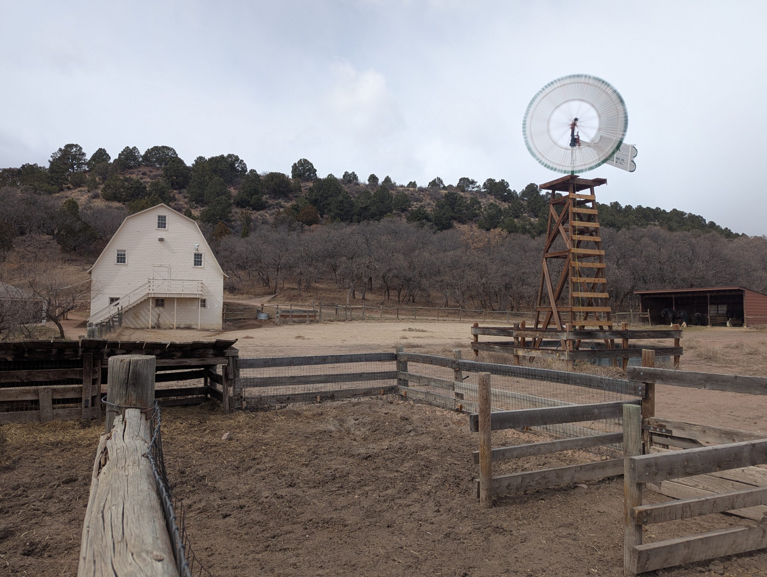
Rock Ledge Ranch Historic Site, located at the entrance to Garden of the Gods Park in Colorado Springs, is a living history museum that brings the story of the Pikes Peak region to life. Managed by the City of Colorado Springs, the ranch preserves over 200 years of local history, with costumed interpreters, historic structures, and seasonal events that connect visitors to Colorado’s cultural heritage.
History and Interpretation
The site spans four eras of history, each represented by authentic buildings and demonstrations:
1775 Ute Encampment – Explore the culture and traditions of the indigenous Ute people.
1860s Homestead Cabin – Step inside a frontier homestead and experience pioneer life.
1880s Chambers Farm & Rock Ledge House – Learn about farming, ranching, and daily life in the late 19th century.
1907 Edwardian Country Estate (Orchard House) – Tour an elegant estate that reflects Colorado Springs’ early resort era.
Through living history, demonstrations, and interpretive programming, Rock Ledge Ranch offers a unique chance to experience the challenges and triumphs of the region’s past.
Programs and Events
Rock Ledge Ranch is host to popular annual events including the Fourth of July Celebration, First People’s Day, Harvest Festival, and the Holiday Evening. These programs highlight historic traditions, cultural exchange, and community celebrations. Educational tours, field trips, and volunteer opportunities are also offered year-round.
Scenery and Location
Nestled against the dramatic red rock formations of Garden of the Gods, the ranch blends history with stunning natural beauty. Visitors can stroll the grounds, picnic in designated areas, or combine a ranch visit with a hike in the Garden of the Gods park next door.
Plan Your Visit
Location: 3105 Gateway Road, Colorado Springs, CO 80904
Parking: Free parking is available on-site in a large gravel lot adjacent to the ranch entrance.
Hours: Seasonal schedule, typically Memorial Day through Labor Day with select off-season events. Grounds are open dusk to dawn.
With its rich storytelling, hands-on demonstrations, and unbeatable setting beside Garden of the Gods, Rock Ledge Ranch Historic Site is one of Colorado Springs’ most unique destinations for history lovers, families, and visitors of all ages.
Florissant Fossil Beds National Monument
Florissant Fossil Beds National Monument in Teller County, Colorado, protects one of the richest fossil deposits in the world. Covering more than 6,000 acres, this National Park Service site offers visitors a rare opportunity to explore ancient history, dramatic geology, and the beauty of Colorado’s mountain landscape all in one place.
Trails and Recreation
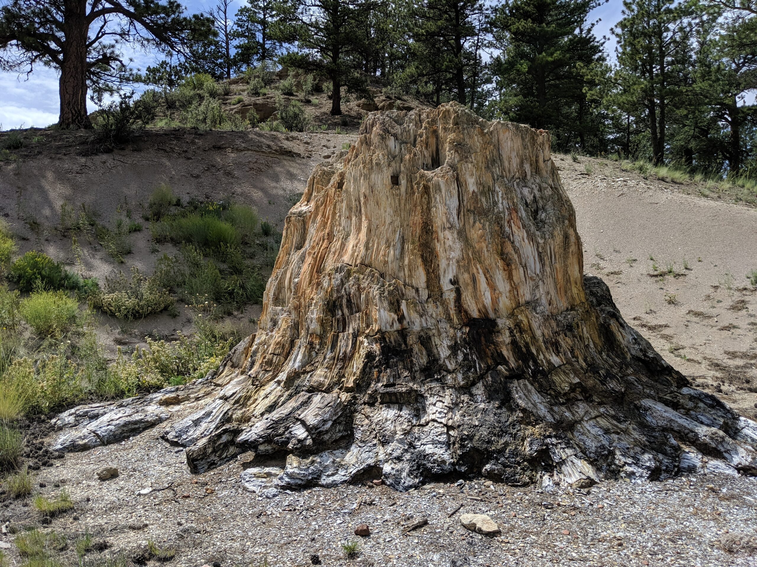
The Monument features 14 miles of hiking trails, ranging from short family-friendly loops to longer treks through forests, meadows, and past historic homesteads. Popular trails include the Petrified Forest Loop, which showcases massive fossilized redwood stumps, and the Hornbek Homestead Trail, offering a glimpse of 19th-century pioneer life. Ranger-led programs, fossil displays, and interactive exhibits at the visitor center make this a perfect stop for families, students, and curious explorers.
Fossils and Geology
The Florissant valley was once a subtropical ecosystem, home to towering redwoods, giant insects, and hundreds of plant species. Volcanic eruptions 34 million years ago buried the valley in ash, preserving thousands of fossils in fine-grained shale. Today, visitors can see petrified tree stumps up to 14 feet wide and view one of the most diverse insect fossil collections ever discovered.
Wildlife and Scenery
Beyond fossils, the Monument is a haven for wildlife. Elk, mule deer, black bear, and fox are frequently spotted, along with a wide variety of birds including mountain bluebirds and hummingbirds. Open meadows dotted with wildflowers and sweeping views of Pikes Peak provide a stunning backdrop year-round.
History
In addition to its prehistoric treasures, Florissant Fossil Beds preserves the Hornbek Homestead, a restored 1870s ranch house that tells the story of early Colorado pioneers. Archaeological evidence also shows that Native American groups, including the Ute, visited the valley for thousands of years.
Plan Your Visit
The Monument is located just west of the town of Florissant, Colorado, about 35 miles from Colorado Springs. The visitor center is open year-round (with seasonal hours), offering exhibits, a bookstore, and trail access. A small entrance fee is required; federal passes are accepted.
With its unique combination of world-class fossils, scenic hiking, and rich human history, Florissant Fossil Beds National Monument is one of Colorado’s most fascinating places to explore.
Bluestem Prairie Open Space offers 646 acres of prairie grassland and bird watching paradise. Home to over 200 bird species and several mammal species, Bluestem Prairie Open Space has become a refuge for a variety of native wildlife and vegetation. Roughly 9 miles of flowing, dirt single track trail make it an ideal location for beginner mountain bikers. The area has no shade, bring plenty of water if you visit in the summer, we recommend visiting early in the morning or evening.
NOTE: No dogs allowed, due to native wildlife.
History: Located just south of the Colorado Springs Municipal Airport, this land once belonged to the Banning-Lewis Ranch. Here ranchers relied primarily on rich soils and thriving grasslands to survive. This land remains home to varied mammals such as the Pronghorn, the Black-tailed prairie dog and birds like the Red-tailed hawk, Burrowing owls and Migratory Shorebirds.
In the fall of 2000, the Trust for Public Land purchased the Big Johnson property from Cygnet Land, LLC and then conveyed the property to the City of Colorado Springs. The City used funds from its Trails, Open Space, and Parks (TOPS) sales tax and a grant from Great Outdoors Colorado (GOCO) to acquire the property. View BIG JOHNSON OPEN SPACE MASTER PLAN.
The namesake “bluestem” highlights the tallgrass species found in northwest portion of the property, while the more predominant shortgrass community in the bowl-shaped valley surrounds the privately-owned Big Johnson Reservoir. The Bluestem Prairie Open Space Management Plan was adopted by the Park and Recreation Advisory Board on March 10, 2016.
Woodmen Trail is a neighborhood focused urban trail in northern Colorado Springs that provides an important east west connection through the Briargate area. Following a powerline corridor, this paved trail offers a convenient option for walking, running, biking, and everyday recreation for nearby residents.
Trail Experience
Woodmen Trail is approximately 2.5 miles long and is constructed of smooth concrete. The trail runs east to west between Woodmen Road and Briargate Boulevard, beginning just west of Austin Bluffs Parkway and extending to just past Union Boulevard. Rolling hills along the corridor create noticeable elevation gain and loss, giving the trail a moderate rating despite its relatively short length.
The trail is popular with local users, is stroller friendly, and includes several benches along the route for resting and enjoying the surroundings. Wildflowers fill the fields around the trail in late summer.
Road Crossings and Safety
Users should expect a mix of neighborhood street crossings and larger roadway crossings along Woodmen Trail. Major crossings include Union Boulevard, Rangewood Drive, and Lexington Drive. The Union Boulevard crossing is accessed via the signalized intersection at Briargate Boulevard. Rangewood Drive includes a marked crosswalk, though vehicles may not consistently yield. Lexington Drive features a signalized pedestrian crossing.
Connections
Woodmen Trail transitions into Skyline Trail near the intersection of Briargate Boulevard and Union Boulevard, where the route shifts north. An unmarked connection to Briargate Trail occurs near Yellowwood Drive, allowing users to continue north. Multiple neighborhood access points are available along the length of the trail.
Management
Woodmen Trail is managed by the City of Colorado Springs Parks, Recreation and Cultural Services Department. Phone: 719 385 5940
Templeton Gap Trail – Colorado Springs, CO
Templeton Gap Trail is an important east west multi use trail in central Colorado Springs that follows the Templeton Gap Floodway. The trail provides a key connection between neighborhoods, parks, open spaces, and several major trail corridors, making it a popular route for both recreation and transportation.
Trail Experience
Templeton Gap Trail is approximately 4 miles long and runs primarily east to west alongside the Templeton Gap Floodway. The trail begins near Mark Dabling Boulevard at the Goose Gossage Youth Sports Complex and continues west to Palmer Park, with a northern fork extending toward Union Meadows Open Space near Austin Bluffs Boulevard and Union Boulevard.
The trail surface is primarily concrete, with some sections of asphalt and gravel. Elevation changes are generally mild, though users should expect a few moderate hills along the route.
Road Crossings and Navigation
Templeton Gap Trail includes several street crossings, including a major crossing at North Nevada Avenue. A short discontinuity exists near North Hancock Avenue by Portal Park. The trail runs on both sides of the floodway; however, to pass under Union Boulevard near Hancock Avenue, it is recommended to remain on the south side of the floodway for a more continuous route.
Connections
Templeton Gap Trail connects directly to the Pikes Peak Greenway at Goose Gossage Youth Sports Complex. From this location, users can also access Sinton Trail to continue west. On the eastern end, the trail links to Austin Bluffs Trail near North Union Boulevard, providing access toward the University of Colorado Colorado Springs campus. Additional connections include Greencrest Trail into Palmer Park and easy access to Union Meadows Open Space.
Cottonwood Creek Trail – Colorado Springs, CO
Cottonwood Creek Trail is a major east west urban trail in northern Colorado Springs and a key connector within the city’s trail system. Following Cottonwood Creek, the trail links neighborhoods, parks, and regional trail corridors while providing a smooth and accessible route for everyday recreation and transportation.
Location: Northern Colorado Springs, following Cottonwood Creek from Powers Boulevard to the Pikes Peak Greenway near I 25
Trail Experience
Cottonwood Creek Trail is just over 6 miles long and features a smooth concrete surface throughout. The trail runs east to west along Cottonwood Creek, beginning near Frank Castello Park at Powers Boulevard and continuing west to connect with the Pikes Peak Greenway and Front Range Trail near I 25.
The trail is generally flat with gentle elevation changes, making it accessible for walkers, runners, cyclists, families, and users of mobility devices. The corridor offers a mix of riparian habitat, open space, and neighborhood views, with long straight segments that are well suited for longer outings or commuting. Benches, trail access points, and nearby amenities allow users to easily tailor trips to their preferred distance and pace.
A dirt trail alternative runs between Union Boulevard and Rangewood Drive, providing a more natural surface option and forming a pleasant 3 mile loop with convenient parking at Cottonwood Creek Community Park.
Road Crossings and Navigation
Cottonwood Creek Trail includes one major street crossing at Union Boulevard. Trail users should use the marked crosswalk at Woodland Hills Drive when crossing Union Boulevard. The trail passes alongside Frank Castello Park and includes a spur connection to Dublin Park; however, accessing Dublin Park requires crossing Dublin Boulevard, which currently does not have a designated pedestrian crossing.
Connections
Cottonwood Creek Trail connects directly to the Pikes Peak Greenway and Front Range Trail just south of the Woodmen Road and Rockrimmon Boulevard area. Multiple neighborhood access points provide easy connections to Cottonwood Creek Community Park, nearby residential areas, and the YMCA. The trail also links to Woodmen Trail and other local trail segments, strengthening north south and east west connectivity across northern Colorado Springs.
Skyline Trail – Colorado Springs, CO
Skyline Trail is a neighborhood focused urban trail in northern Colorado Springs that provides an important north south connection through the Briargate area. Often referred to locally as the Powerline Trail due to its alignment with overhead powerlines, Skyline Trail is well used by nearby residents for walking, running, and biking.
Skyline Trail is approximately 2 miles long and features a mix of wide concrete and dirt trail surfaces. South of Research Parkway, the trail is smooth concrete, while the segment north of Research Parkway transitions to a dirt surface. Rolling terrain creates noticeable elevation gain and loss, giving the trail a moderate difficulty rating.
The trail includes several distinctive switchbacks near Mirage Drive that offer views across the surrounding neighborhoods and open spaces. Despite its urban setting, the corridor provides a sense of separation from nearby roads and is popular for short neighborhood outings as well as longer connected trips.
Road Crossings and Navigation
Skyline Trail includes several street crossings and users should proceed with caution at all crosswalks. Major crossings occur at Briargate Boulevard and Research Parkway. When crossing Research Parkway, users should use the signalized intersection at Chapel Hills Drive for improved safety. Trail signage varies by segment, and awareness is recommended when navigating transitions between surfaces.
Connections
Skyline Trail transitions into Woodmen Trail at Briargate Boulevard, allowing users to continue east west through northern Colorado Springs. A spur trail provides access to Rampart Community Park, which includes a disc golf course, sports courts and fields, and a dog park. The trail passes near High Plains Elementary School and offers views of Reflection Pond, which can be accessed via sidewalks on Parliament Drive.
Sidewalk connections along Briargate Parkway allow access to John Venezia Community Park and the Briargate Trail. Multiple neighborhood access points along the route make Skyline Trail easy to reach from surrounding residential areas.
Skyline Trail plays an important role in connecting neighborhoods, parks, and trails across northern Colorado Springs while offering a moderately challenging route with varied terrain and strong local use.
Sinton Trail – Colorado Springs, CO
Sinton Trail is a scenic urban trail in central Colorado Springs that follows Douglas Creek and an adjacent drainage canal. The trail offers a peaceful corridor through an otherwise developed area, connecting major trail systems while providing opportunities to experience wildlife, seasonal color, and quiet open space close to the city.
Location: Central Colorado Springs, between Garden of the Gods Road and Mark Dabling Boulevard
Trail Experience
Sinton Trail is approximately 3 miles long and runs northwest to southeast between Garden of the Gods Road and Mark Dabling Boulevard, just north of the Goose Gossage Youth Sports Complex. The trail surface is primarily asphalt, with short sections of concrete and gravel. Elevation changes are gradual, with a gentle uphill grade when traveling west.
The trail is well suited for walking, running, and biking and is accessible to a wide range of users. One of the highlights of the trail is its proximity to water and riparian habitat, which supports birdwatching opportunities, particularly near Sinton Pond Open Space. Waterfowl, songbirds, and other wildlife are commonly observed in this area.
In autumn, mature cottonwoods and other trees along the corridor provide vibrant fall color, making Sinton Trail especially popular during the changing seasons. The combination of water, vegetation, and separation from traffic creates a calm and immersive trail experience.
Road Crossings and Navigation
Sinton Trail includes two at grade street crossings at North Chestnut Road and Holland Park Boulevard. The trail also passes under Centennial Boulevard via a narrow metal tunnel, which requires users to proceed with caution and be aware of oncoming traffic, particularly cyclists.
Connections
Sinton Trail connects directly to the Pikes Peak Greenway and Templeton Gap Trail, making it an important link within Colorado Springs’ urban trail network. With minimal use of sidewalks and local streets, users can also reach 30th Street to connect with the Foothills Trail and Garden of the Gods Park.
A short dirt path provides access to Sinton Pond Open Space, a 13 acre natural area that offers a quiet detour and additional wildlife viewing opportunities within a densely developed part of the city.
Sinton Trail serves as both a functional connector and a natural refuge, offering year round recreation, seasonal beauty, and access to some of Colorado Springs’ most popular trail corridors.
Shooks Run Trail – Colorado Springs, CO
Shooks Run Trail is a central Colorado Springs urban trail that follows Shooks Run Creek through historic neighborhoods, community spaces, and growing arts and garden corridors. The trail provides an easy, accessible route for walking, biking, and everyday recreation while connecting several key trail systems and local destinations.
Location: Central and southeast Colorado Springs, following Shooks Run Creek from Lilac Street to Fountain Boulevard
Trail Experience
Shooks Run Trail is approximately 4 miles long and runs north to south along Shooks Run Creek. The trail begins near Lilac Street and the Rock Island Trail in the north and continues south to Fountain Boulevard and South Shooks Run Park. The paved surface makes for an easy walk or ride, with a slight downhill grade when traveling south.
The trail is well suited for all ages and abilities, with benches and picnic tables placed along the route for rest and gathering. Shooks Run passes through residential areas and community focused spaces, creating a neighborhood oriented experience that blends everyday use with access to nature. Several street crossings occur along the trail, so users should proceed with awareness at intersections. Several parks can be found along or near the trail.
History and Character
One of the defining features of Shooks Run Trail is its connection to Colorado Springs’ early rail history. At the southern end of the trail, users pass through a historic rail underpass built in 1887, a reminder of the city’s industrial and transportation roots. Beyond the underpass, the trail reaches the Concrete Coyote property, owned and stewarded by Concrete Couch, which has become a hub for community creativity and placemaking.
Connections
Shooks Run Trail connects directly to the Rock Island Trail, expanding access to north south travel across the city. Sidewalks and neighborhood streets provide frequent access points along the route, making the trail easy to reach from surrounding homes and businesses.
With limited on street or sidewalk travel, users can connect to the Pikes Peak Greenway, further linking Shooks Run into the broader Front Range trail network. The trail also passes near Pikes Peak Urban Gardens and the Sustain a Center, where the Trails and Open Space Coalition office is located just off the corridor.
Shooks Run Trail plays an important role in connecting neighborhoods, supporting local community spaces, and strengthening the urban trail network in Colorado Springs. It is a trail built for everyday use, local connection, and continued investment in accessible outdoor spaces.
Rock Island Trail – Colorado Springs, CO
The Rock Island Trail in Colorado Springs follows a historic railroad corridor through the heart of the city, providing an easy, accessible east west route that connects neighborhoods, parks, and major trail systems. Built along the former Rock Island Railroad bed, the trail reflects the city’s transportation history while serving modern recreation and commuting needs.
Location: Central Colorado Springs, running east west alongside Constitution Avenue from Weber Street to Powers Boulevard
Trail Experience
The Colorado Springs segment of the Rock Island Trail is approximately 6 miles long. It runs east west from Weber Street to Powers Boulevard, generally paralleling Constitution Avenue. The trail surface is a mix of concrete and asphalt, creating a smooth and accessible experience for walking, biking, and other non motorized uses.
The trail has a gentle grade, with a gradual uphill slope when traveling east. Several at grade street crossings occur along the route, so users should exercise caution at intersections. The corridor passes through residential areas and urban landscapes, offering a practical and well used route for everyday recreation and transportation.
Connections
Rock Island Trail connects directly to the Shooks Run Trail, creating a continuous north south and east west trail link through the city. With limited street or sidewalk travel, users can also connect to the Pikes Peak Greenway, Homestead Trail, and Palmer Park, making this trail an important part of Colorado Springs’ broader urban trail network.