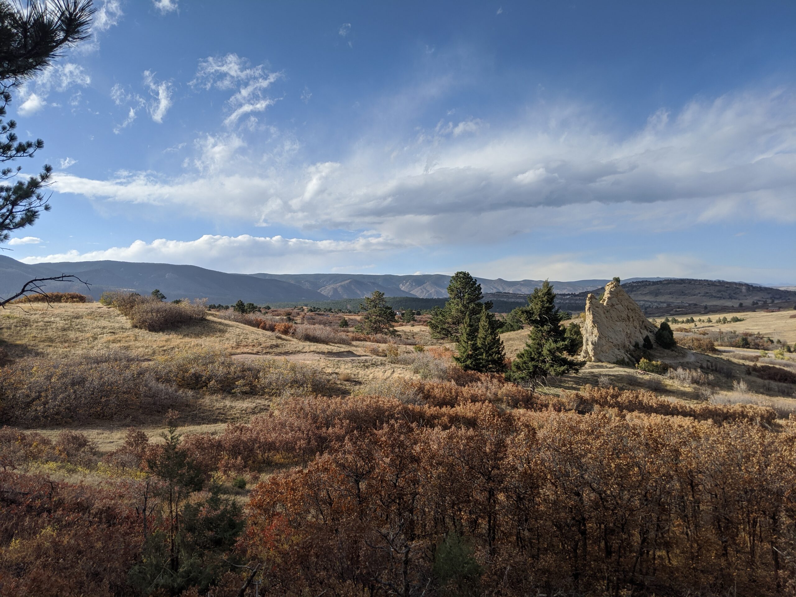
Nestled along the Front Range between Larkspur and Perry Park, Sandstone Ranch Open Space is a 2,038-acre property offering visitors a stunning blend of red rock formations, rolling meadows, ponderosa pine forests, and historic ranchland. Opened to the public in 2020, this open space highlights the beauty and heritage of Douglas County while protecting vital wildlife habitat and cultural resources.
Recreation and Trails
Sandstone Ranch features nearly 12 miles of multi-use trails for hikers, bikers, and equestrians. Popular routes include the Sandstone Meadow Trail, winding through expansive grasslands, and the Sandstone Ridge Trail, which climbs into forests and sandstone outcrops with sweeping views of Pikes Peak. Picnic areas and interpretive signage provide places to pause and appreciate both the scenery and history.
Wildlife and Scenery
The diverse landscapes of Sandstone Ranch support elk, mule deer, wild turkeys, black bears, and bobcats, while raptors soar above the ridgelines. In spring and summer, meadows burst with wildflowers, contrasting beautifully with the striking red sandstone cliffs. Autumn brings golden stands of aspen and cottonwood, making the open space a year-round destination for photographers and nature lovers.
History
For centuries, Native peoples traveled through this landscape, followed by homesteaders and ranchers who shaped the land into productive pasture. The Sandstone Ranch property was operated as a working ranch for over 150 years before Douglas County, with support from Great Outdoors Colorado (GOCO) and other partners, secured it for conservation. The historic ranch headquarters remains, offering a glimpse into Colorado’s ranching heritage.
Plan Your Visit
Location: 2028 N. Perry Park Road, Larkspur, CO 80118 Parking: Main lot at the trailhead with space for horse trailers. Hours: Open daily, one hour before sunrise to one hour after sunset. Fees: No entry fee. Tips:
Dogs must remain on leash at all times.
Carry plenty of water—there are no facilities along the trails.
Trails can be icy in winter and muddy in spring—plan footwear accordingly.
With its sweeping views, rich history, and diverse recreation opportunities, Sandstone Ranch Open Space is a crown jewel of Douglas County’s open space system and a must-visit for anyone looking to experience Colorado’s natural and cultural heritage.
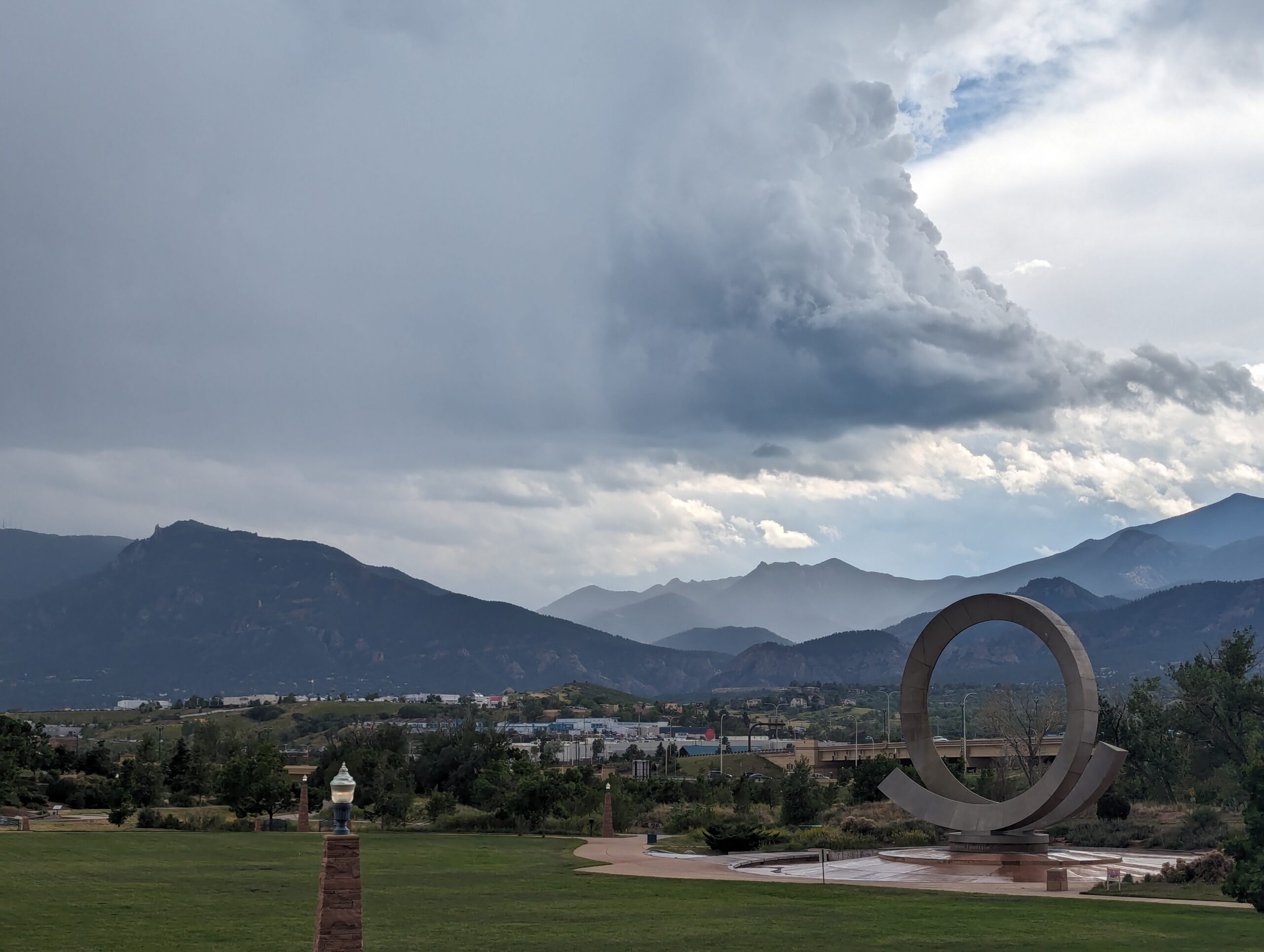
Nestled at the base of Pikes Peak and just steps from downtown Colorado Springs, America the Beautiful Park is a vibrant urban green space that combines recreation, art, and community. The park’s name honors Katharine Lee Bates, who penned the song “America the Beautiful” after visiting the summit of Pikes Peak in 1893.
Recreation and Amenities
The 30-acre park is designed for families, gatherings, and outdoor fun. It features large open lawns perfect for picnics and games, a universally accessible playground that welcomes children of all abilities, and plenty of paved trails for walking, running, and cycling. The park also connects directly to the Pikes Peak Greenway Trail, making it a popular hub for commuters and recreationists.
Iconic Features
The centerpiece of the park is the “Continuum” sculpture and Julie Penrose Fountain, a 60-foot circular structure that sprays water high into the air, creating a refreshing play space in summer and a striking landmark year-round. Its design represents the continuous motion of water and life, making it one of the city’s most recognized symbols.
Wildlife and Scenery
While the park sits in the heart of the city, visitors can still enjoy views of Pikes Peak and the Front Range, along with the chance to spot urban wildlife along the trails and nearby Fountain Creek. Its open design offers both green lawns and mountain vistas, making it a scenic gathering place.
History
Created in the early 2000s, America the Beautiful Park was envisioned as a community centerpiece, blending public art, accessible play, and trail connections into one landmark park. It has since become a favorite spot for festivals, concerts, and family outings while honoring the region’s deep connection to the iconic song.
Plan Your Visit
Location: 126 Cimino Drive, Colorado Springs, CO 80903 Parking: Free parking is available on-site, though spaces can fill quickly during events. Hours: Open daily, 5:00 a.m. – 9:00 p.m. More Information: https://coloradosprings.gov/parks/page/america-beautiful-park Tips:
Bring kids in summer to enjoy the splash fountain.
Walk or bike to the park via the Pikes Peak Greenway for a car-free adventure.
Check the city events calendar—many community festivals and cultural events take place here.
With its combination of art, recreation, and breathtaking views of the mountains, America the Beautiful Park truly lives up to its name as one of Colorado Springs’ most iconic gathering spaces.
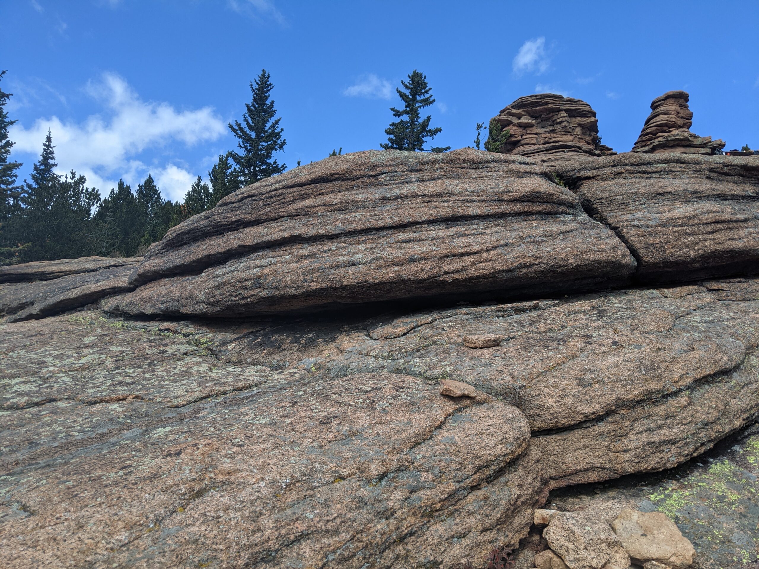
Pancake Rocks Trail
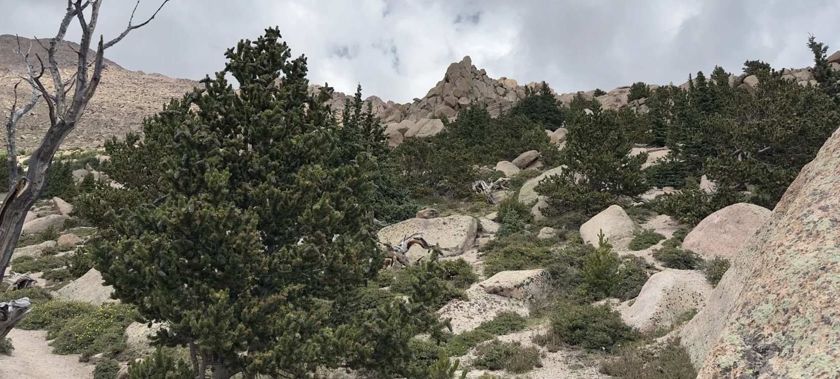
The Pancake Rocks Trail near Cripple Creek is one of the most beloved high-country hikes in the Pikes Peak region, famous for its unusual, layered rock formations that resemble a towering stack of pancakes. At over 10,000 feet in elevation, this hike combines geological wonders, sweeping views, and a true alpine adventure.
Trails and Hiking
The trail to Pancake Rocks begins from Horsethief Park and climbs steadily through spruce and fir forest. Hikers can expect about 6 miles round trip with roughly 1,200 feet of elevation gain, making it a moderate-to-challenging trek. The highlight is reaching the natural sandstone and granite formations, where the rock has weathered into stacked, flat shelves that look like giant pancakes tipped on their side.
Wildlife and Scenery
Along the way, hikers are treated to dense forest, alpine meadows, and breathtaking views of Pikes Peak’s south slopes and the surrounding Teller County high country. Wildlife sightings often include marmots, pikas, mule deer, and a variety of alpine birds. In late summer, wildflowers add splashes of color to the meadows, while fall brings golden aspen groves.
History
The Pancake Rocks area has long been a favorite local hike, with its unique formations formed over millions of years by erosion and uplift. Once traveled by miners and early settlers moving between Cripple Creek and Divide, today it is a treasured recreational destination managed by the Pike National Forest.
Plan Your Visit
Location: Access off CO Highway 67 between Divide and Cripple Creek. The Horsethief Park Trailhead is closest. Parking: Parking strip along HWY with various pulloffs further away. Hours: Open year-round, though snow and ice can make the trail difficult outside of summer and fall. Tips:
At high elevation, weather changes quickly—dress in layers and be prepared for storms.
Bring plenty of water; there are no reliable water sources on the trail.
Dogs are allowed but should be leashed to protect wildlife and fellow hikers.
Start early to avoid afternoon thunderstorms common in summer.
With its striking rock formations and spectacular alpine views, Pancake Rocks is a one-of-a-kind hike that rewards every step of the climb.
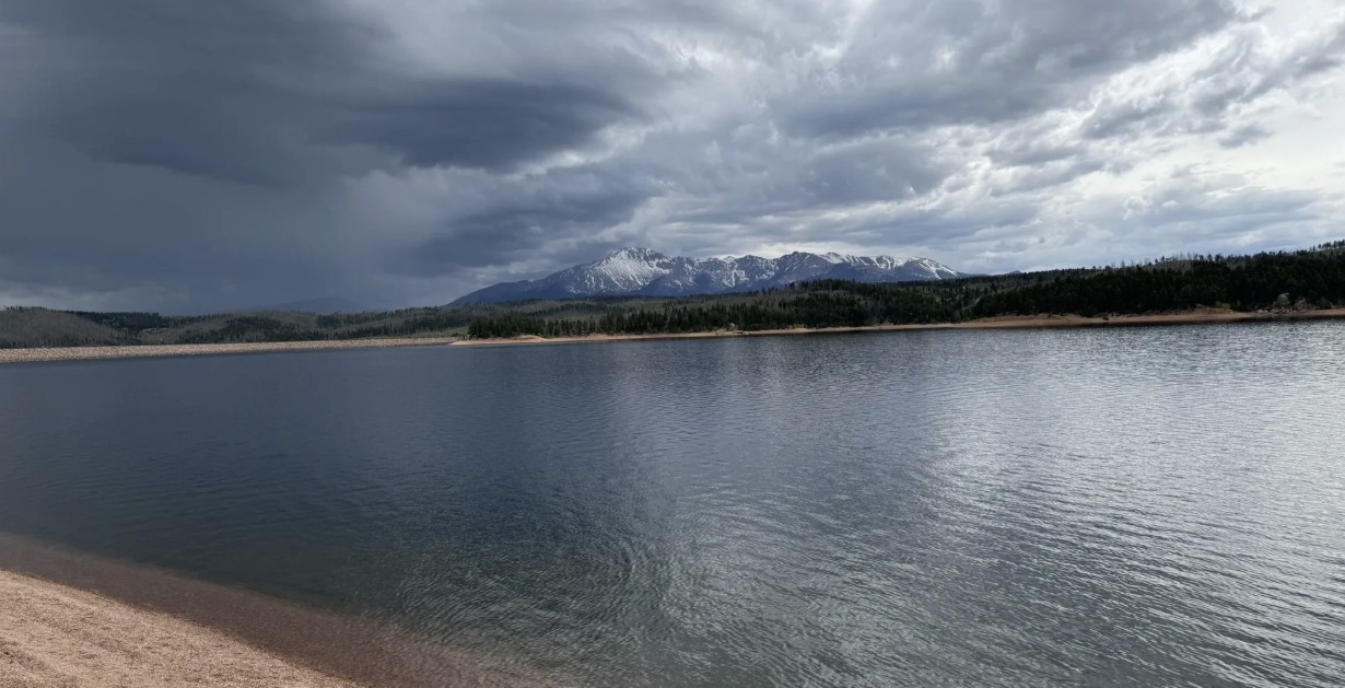
Rampart Reservoir Recreation Area
Rampart Reservoir Recreation Area, located just outside Woodland Park on the north slope of Pikes Peak, is one of the premier destinations in the Pikes Peak region for fishing, boating, hiking, and mountain scenery. At 8,948 feet in elevation, the 500-acre reservoir provides a cool alpine escape with panoramic views of Pikes Peak and the surrounding forests.
Recreation and Trails
Rampart Reservoir is best known for its water-based recreation. Boating is allowed (with motor restrictions), and anglers come for rainbow, lake, and brown trout as well as smallmouth bass. The Rampart Reservoir Trail loops around the water for 13 miles, popular with hikers, trail runners, and mountain bikers. Shorter access trails, such as Rainbow Gulch Trail, provide family-friendly options and scenic shoreline hikes.
Wildlife and Scenery
With its sparkling waters framed by dense pine and spruce forests, Rampart Reservoir is a photographer’s dream. Wildlife is abundant—visitors often spot bald eagles, ospreys, mule deer, foxes, and the occasional black bear. In summer, wildflowers brighten the trails, while fall brings golden aspen groves.
History
The reservoir was constructed in 1969 by the City of Colorado Springs as part of the municipal water system. Beyond serving as an essential water storage site, it quickly became a popular recreation area, drawing visitors from across the Front Range for its combination of outdoor opportunities and alpine beauty.
Plan Your Visit
Location: About 4 miles east of Woodland Park, accessible via Rampart Range Road. Parking: Multiple paved and gravel parking areas are available near trailheads and boat ramps. A day-use fee is required. Hours: Open seasonally, late May through mid-October, from 6:00 a.m. to 8:00 p.m. (hours vary by season). Closed in winter. Tips:
A Colorado fishing license is required for anglers.
Dogs are allowed but must be leashed.
Bring layers—weather can change quickly at nearly 9,000 feet.
The loop trail is long and exposed in places; bring plenty of water and sun protection.
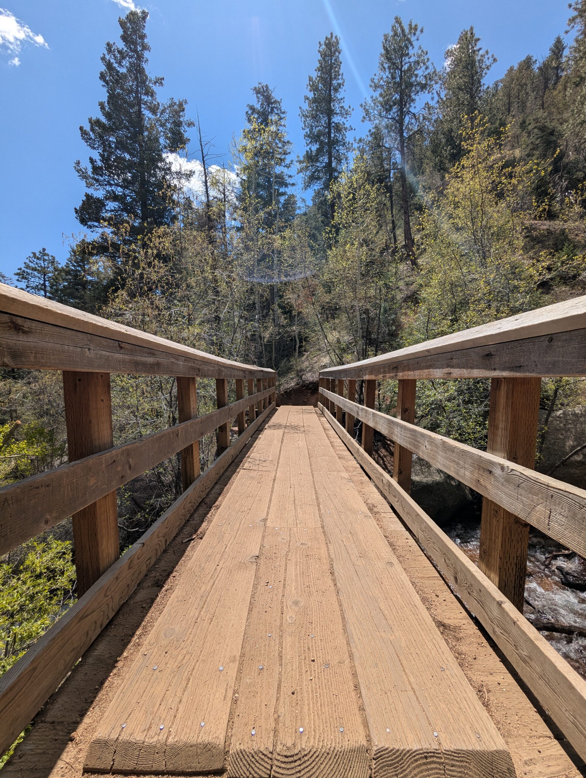
The Seven Bridges Trail, also known as Trail #622, is one of the most popular hikes in North Cheyenne Cañon. This moderate trail is about 3.7 miles round trip and gains roughly 1,000 feet in elevation as it follows North Cheyenne Creek. Its charm comes from crossing seven rustic wooden bridges that give the trail its name, making it a family-friendly adventure with plenty of photo opportunities.
Trails and Recreation
The trail begins at the end of North Cheyenne Canyon Road near the parking area for the Upper Gold Camp Road. From there, hikers follow a steady incline along a shaded canyon trail, crossing over seven picturesque wooden bridges. Beyond the seventh bridge, the path continues into steeper terrain and can be extended to connect with higher trails like Jones Park or Mount Rosa for those looking for a longer trek.
Wildlife and Scenery
Surrounded by towering evergreens, mountain streams, and granite walls, the Seven Bridges Trail offers classic Front Range beauty. Depending on the season, hikers may encounter wildflowers, colorful autumn foliage, or sparkling ice formations along the creek. Wildlife is common in the area—mule deer, songbirds, and the occasional black bear may be spotted in the canyon.
History
The trail follows an old pipeline route that once carried water from the mountains into Colorado Springs in the early 20th century. The bridges were originally constructed to maintain access along the pipeline, and today they remain a beloved feature of this historic route.
Plan Your Visit
Location: Trailhead parking is located at the end of North Cheyenne Canyon Road, just past the closed Gold Camp Road tunnel. Parking: A paved lot is available, but it fills quickly—arrive early, especially on weekends. Additional parking may be available further down the road. Hours: Open daily, 5:00 a.m. – 9:00 p.m. Tips:
The trail is well-shaded, making it a great summer hike.
Dogs are welcome but must be leashed.
Wear sturdy shoes, as the path can be rocky and icy in colder months.
Continue past the seventh bridge if you want to extend your hike into the higher country of Pike National Forest.
Barr Trail
Barr Trail is one of Colorado’s most iconic and challenging hikes, climbing from the base of Manitou Springs to the 14,115-foot summit of Pikes Peak. Stretching about 13 miles one way, this legendary route is a favorite for experienced hikers, trail runners, and those seeking to follow in the footsteps of Katherine Lee Bates, who wrote “America the Beautiful” after visiting the summit. With nearly 7,400 feet of elevation gain, Barr Trail is considered one of the most demanding long-distance trails in the Pikes Peak region.
Trails and Recreation
Barr Trail begins near the Cog Railway Depot in Manitou Springs and winds through diverse terrain, from foothill forests to high-alpine tundra. Many hikers split the journey by stopping overnight at Barr Camp, a rustic backcountry lodge about 6.5 miles up the trail. Others use the trail for training runs or as a route to complete the famous Pikes Peak Ascent and Marathon. Whether you tackle a section or the entire summit, Barr Trail delivers a one-of-a-kind adventure.
Wildlife and Scenery
Along the way, hikers pass through lush ponderosa pine forests, groves of aspen, and wildflower-filled meadows before entering the rocky alpine zone. Wildlife sightings may include mule deer, marmots, pikas, black bear, and a wide range of bird species. The higher you climb, the more expansive the views become—eventually opening up to sweeping panoramas of the Front Range, Colorado Springs, and the eastern plains.
History
Barr Trail was built in the early 1900s by Fred Barr, who envisioned a route that would allow hikers and equestrians to reach the summit of Pikes Peak. Barr also established Barr Camp as a stopping point along the way, which continues to serve outdoor enthusiasts today. The trail’s connection to the region’s cultural and recreational history has made it a cornerstone of Colorado hiking.
Plan Your Visit
Location: Trailhead located near 540 Ruxton Avenue, Manitou Springs, CO, adjacent to the Cog Railway Depot. Parking: Limited parking is available near the trailhead; many visitors use Manitou Springs public lots or shuttle systems. Fees may apply. Hours: Open year-round, but conditions can be extreme—check weather forecasts before starting. Tips:
Expect a strenuous hike—be physically prepared and start early.
Carry layers, food, and plenty of water (refills available at Barr Camp).
Afternoon storms are common in summer; plan to be below tree line by midday.
Dogs are allowed but should be kept leashed and acclimated to long climbs.
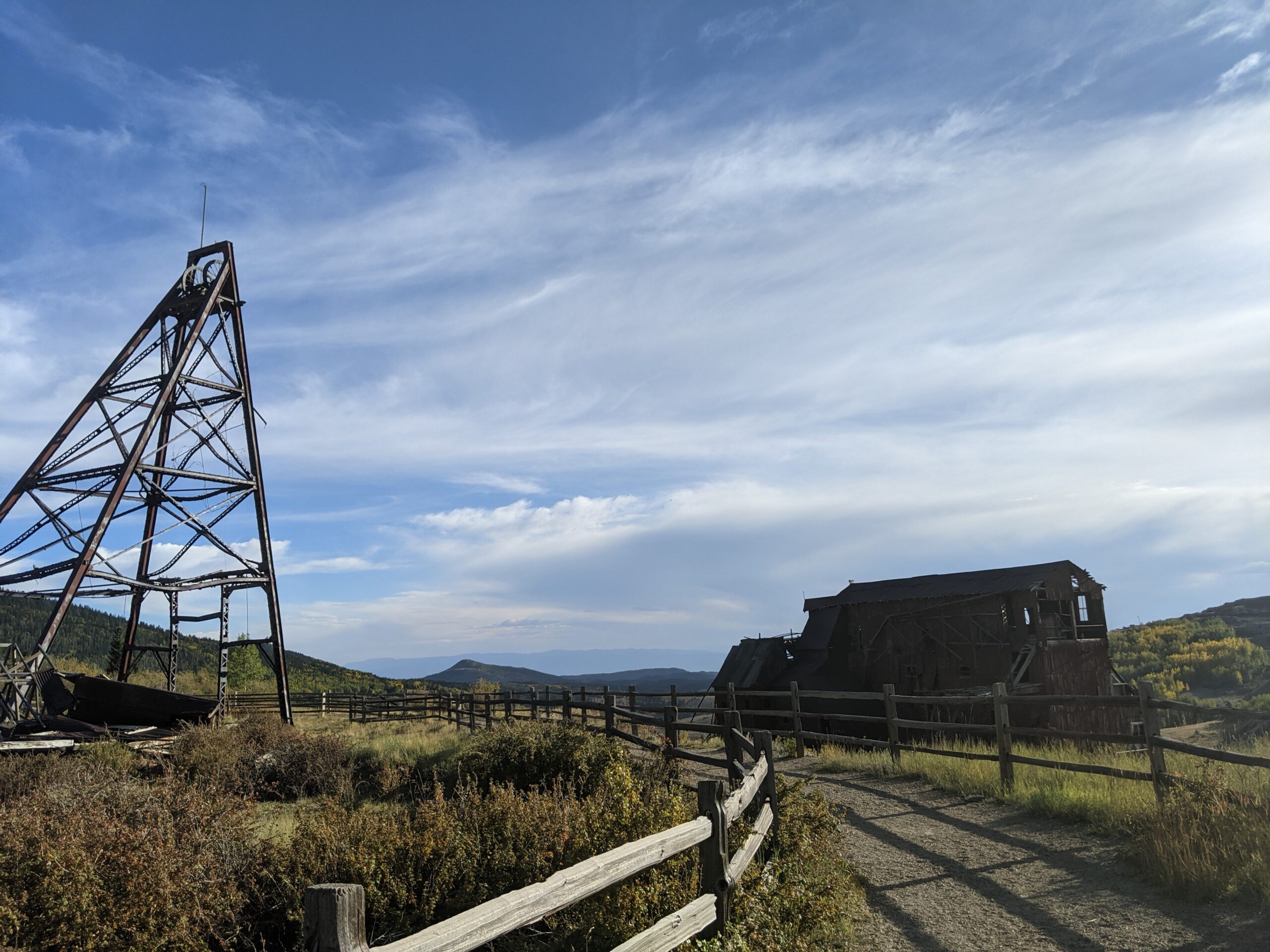
Vindicator Valley Trail
Vindicator Valley Trail in Victor, Colorado, offers a fascinating blend of outdoor recreation, mining history, and scenic beauty in the heart of the Cripple Creek & Victor Mining District. This interpretive loop trail winds through historic mining structures and reclaimed landscapes, giving visitors a glimpse into Colorado’s Gold Rush era while showcasing views of Pikes Peak and the rugged hills of Teller County.
Trails and Recreation
The Vindicator Valley Trail is a 2-mile loop that is rated easy to moderate, making it accessible for most hikers, families, and history enthusiasts. Along the way, you’ll find interpretive signs explaining the mining operations, equipment, and the lives of the people who once worked the area. The trail is popular year-round for hiking, snowshoeing, and photography.
Wildlife and Scenery
While the mining remnants are the highlight, the surrounding landscape is equally striking. Wildflowers bloom in summer, while fall brings golden aspens and crisp mountain air. Mule deer, elk, foxes, and a variety of bird species can often be spotted along the trail. Panoramic views of the Sangre de Cristo and Sawatch mountain ranges add to the experience.
History
Vindicator Valley sits in the heart of the Cripple Creek & Victor Gold Mining District, one of the most productive gold mining areas in the United States during the late 1800s and early 1900s. The trail passes by the historic Vindicator Mine and other structures that once fueled Colorado’s mining boom. Many of these wooden headframes and buildings have been stabilized to preserve them as open-air museums, allowing visitors to connect directly with the region’s past.
Plan Your Visit
Location: Trailhead located just north of Victor, CO off County Road 81 (about 45 minutes west of Colorado Springs). Parking: A gravel lot is available at the trailhead. Parking is free but limited. Hours: Open daily, year-round, from dawn to dusk. Tips:
Interpretive signage is plentiful—allow time to read and explore.
Bring water and sun protection; shade is limited.
Winter visits may require traction devices or snowshoes.
Respect historic structures by staying on designated trails.
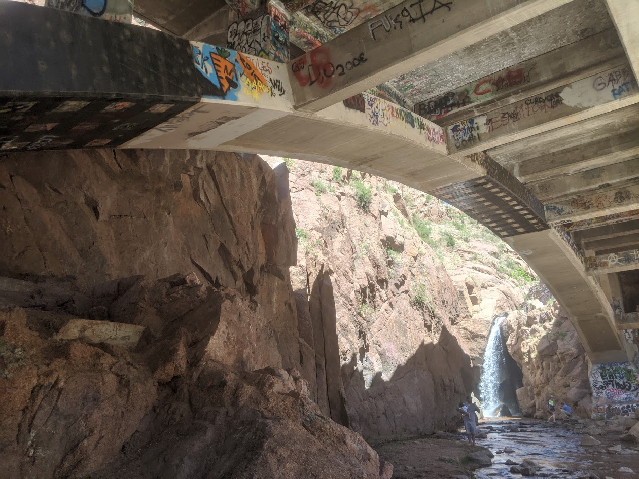
Rainbow Falls Historic Site
Rainbow Falls Historic Site in Manitou Springs is a one of a kind destination that blends natural beauty with local history and art. Known locally as “Graffiti Falls,” this spot features a dramatic waterfall dropping beneath a historic 1930s highway bridge, surrounded by steep canyon walls decorated with colorful community art. Managed by El Paso County Parks, Rainbow Falls has become both a scenic stop and a cultural landmark.
Trails and Recreation
A short, family friendly trail leads directly from the parking area to the base of the falls, making it an easy walk for visitors of all ages. While the trail is less than a quarter mile long, the views of the waterfall and the unique bridge structure make it worth the visit. Benches and interpretive signs along the way provide information about the site’s history, geology, and restoration efforts.
Wildlife and Scenery
The falls are framed by rugged red rock formations typical of the Manitou Springs area. Visitors can often spot small birds, squirrels, and other wildlife along the creek. In winter, ice formations around the falls create another stunning natural display. The sound of rushing water and the backdrop of Pikes Peak Country make Rainbow Falls a memorable stop.
History
Rainbow Falls has been a local gathering spot for decades, with a history that includes Native American heritage, 20th century road construction, and its more recent identity as an urban art space. The bridge spanning the falls was constructed in 1932 as part of Highway 24 and remains a prominent feature today. In recent years, El Paso County Parks has worked to restore and protect the site, balancing its natural character with its role as a space for community expression.
Plan Your Visit
Location: Accessed via Serpentine Drive, just off Highway 24 at the west end of Manitou Springs. Hours: Open seasonally, typically Memorial Day through Labor Day, on weekends and holidays. Hours may vary, so check with El Paso County Parks. Parking: A small parking area is available off Serpentine Drive with a fee required. Parking is limited, so carpooling is recommended. Tips:
The trail is short but uneven in places—sturdy shoes are helpful.
Graffiti is part of the site’s identity, but defacing natural features is prohibited.
The area can be busy on summer weekends; mornings and weekdays are quieter times to visit.
Offsite parking at 101 Higginbotham Road, Manitou Springs, CO 80829, $20 per vehicle.
Bear Creek Cañon Park is a rugged natural escape located just minutes west of downtown Colorado Springs. With over 545 acres of steep terrain, rocky outcrops, and forested canyons, this city owned park offers exciting mountain biking and hiking. It is a favorite destination for outdoor enthusiasts seeking a more wild experience while still being close to town. This is also a popular climbing area.
Trails and Recreation
The park is known for its challenging network of multi use trails that climb quickly into the foothills and connect with nearby open spaces, including Section 16, Red Rock Canyon Open Space, Bear Creek Regional Park and Pike National Forest.
Wildlife and Scenery
Bear Creek Cañon Park offers classic Front Range landscapes—towering ponderosa pines, rugged rock formations, and panoramic vistas of both the city and Pikes Peak. Wildlife sightings are common and may include mule deer, black bear, coyotes, and a wide range of raptors and songbirds. Seasonal wildflowers and fall colors add to the park’s appeal, especially along creekside areas and ridgelines.
History
The park was one of the first areas preserved by the City of Colorado Springs, reflecting General William Jackson Palmer’s vision of protecting scenic natural lands for public use. Its trails and connections to surrounding open spaces have long made it a gateway to the foothills and an important part of the city’s park system.
Plan Your Visit
Location: Main access is from Bear Creek Road & Gold Camp Road Hours: 5:00 a.m. to 9:00 p.m. daily Parking: Limited parking is available at trailheads along Gold Camp Road and near Section 16. Arrive early on weekends to secure a spot. Tips:
Trails are steep and rocky—wear sturdy footwear and carry plenty of water.
Dogs are welcome but must remain on leash.
Expect limited facilities; restrooms are not always available.
Be prepared for changing weather, especially at higher elevations.
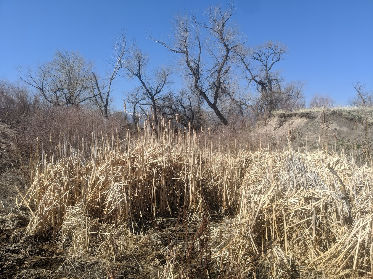
Smith Creek Natural Area
Smith Creek Natural Area is a hidden gem in northern Colorado Springs, offering a peaceful mix of short trails, restored grasslands, and riparian habitat along the creek. Managed as open space, this natural area gives residents and visitors a chance to enjoy a quieter outdoor experience just minutes from growing neighborhoods and commercial corridors.
Trails and Recreation
The natural area features a soft-surface trail system that winds through meadows and along Smith Creek. These trails are well-suited for walking, running, and birdwatching, with gentle terrain that makes them accessible for families and casual hikers. The trails connect to nearby residential paths, making Smith Creek a convenient green escape close to home.
Wildlife & Scenery
Smith Creek is part of a vital riparian corridor that supports diverse wildlife. Birdwatchers may spot hawks, owls, and songbirds, while deer and foxes are occasional visitors to the meadows. The landscape is especially beautiful in spring and early summer when wildflowers bloom and the creek flows strongest. Native grasses and cottonwood trees provide year-round scenery and habitat for pollinators and small mammals.
History
The land around Smith Creek was once used for ranching and agriculture before being set aside as a protected natural area. Today, it is managed with an emphasis on preserving riparian health, supporting wildlife habitat, and giving local residents an accessible space to connect with nature.
Plan Your Visit
Location: Off Voyager Parkway near Interquest Parkway, northern Colorado Springs Hours: Open daily, dawn to dusk Parking: Limited parking is available at nearby trailheads and residential streets—visitors are encouraged to walk or bike in from surrounding neighborhoods. Know Before You Go: Dogs are welcome but must be leashed to protect wildlife. Trails may be muddy after rain or snowmelt, so plan footwear accordingly.