America the Beautiful Park
Nestled at the base of Pikes Peak and just steps from downtown Colorado Springs, America the Beautiful Park is a vibrant urban green space that combines recreation, art, and community. The park’s name honors Katharine Lee Bates, who penned the song “America the Beautiful” after visiting the summit of Pikes Peak in 1893.
Recreation and Amenities
The 30-acre park is designed for families, gatherings, and outdoor fun. It features large open lawns perfect for picnics and games, a universally accessible playground that welcomes children of all abilities, and plenty of paved trails for walking, running, and cycling. The park also connects directly to the Pikes Peak Greenway Trail, making it a popular hub for commuters and recreationists.
Iconic Features
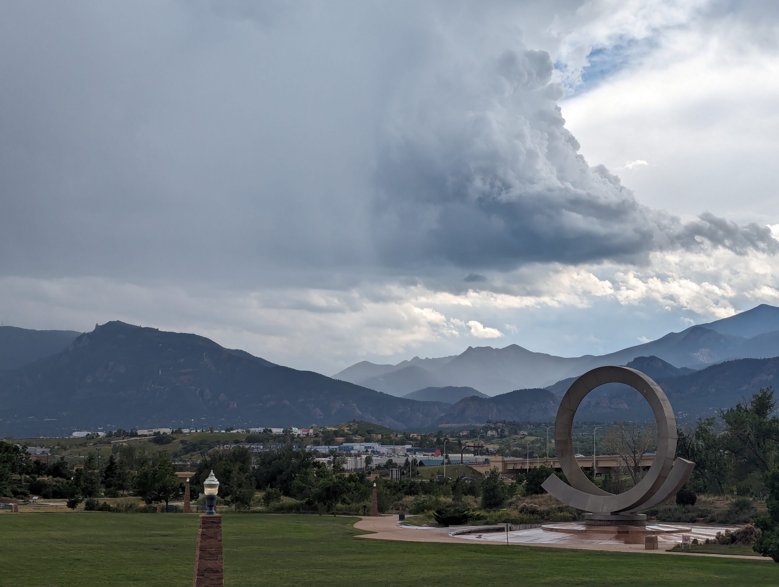
The centerpiece of the park is the “Continuum” sculpture and Julie Penrose Fountain, a 60-foot circular structure that sprays water high into the air, creating a refreshing play space in summer and a striking landmark year-round. Its design represents the continuous motion of water and life, making it one of the city’s most recognized symbols.
Wildlife and Scenery
While the park sits in the heart of the city, visitors can still enjoy views of Pikes Peak and the Front Range, along with the chance to spot urban wildlife along the trails and nearby Fountain Creek. Its open design offers both green lawns and mountain vistas, making it a scenic gathering place.
History
Created in the early 2000s, America the Beautiful Park was envisioned as a community centerpiece, blending public art, accessible play, and trail connections into one landmark park. It has since become a favorite spot for festivals, concerts, and family outings while honoring the region’s deep connection to the iconic song.
Plan Your Visit
Location: 126 Cimino Drive, Colorado Springs, CO 80903
Parking: Free parking is available on-site, though spaces can fill quickly during events.
Hours: Open daily, 5:00 a.m. – 9:00 p.m.
More Information: https://coloradosprings.gov/parks/page/america-beautiful-park
Tips:
-
Bring kids in summer to enjoy the splash fountain.
-
Walk or bike to the park via the Pikes Peak Greenway for a car-free adventure.
-
Check the city events calendar—many community festivals and cultural events take place here.
With its combination of art, recreation, and breathtaking views of the mountains, America the Beautiful Park truly lives up to its name as one of Colorado Springs’ most iconic gathering spaces.

Midland Trail – Colorado Springs, CO
The Midland Trail is a key east west urban corridor in Colorado Springs, following Fountain Creek and the historic Midland rail alignment. The trail provides a smooth, accessible route through the city, connecting downtown destinations, parks, and major trail systems while offering views of the creek and surrounding landscape.
Location: West and central Colorado Springs, paralleling U.S. Highway 24 (Cimarron Street) from America the Beautiful Park to Ridge Road
Trail Experience
The Midland Trail is approximately 8 miles long and runs east west along Fountain Creek. The trail begins near America the Beautiful Park in downtown Colorado Springs and continues west to Ridge Road. The surface is primarily concrete, making it suitable for walking, biking, and other non motorized uses.
The trail features a mild grade, with a gradual downhill slope when traveling east. Several at grade street crossings occur along the route, with pedestrian signals at major crossings including 31st Street and 8th Street. There is a short gap in the trail between 21st Street and 25th Street, where users are directed to use Naegele Road, a lightly traveled roadway.
The corridor blends urban scenery with riparian habitat along Fountain Creek and passes through areas of public art and community investment. An art bench created by Concrete Couch can be found near 17th Street and serves as a unique landmark along the trail.
Connections
Midland Trail connects directly to the Pikes Peak Greenway, America the Beautiful Park, and the U.S. Olympic and Paralympic Museum. With limited street or sidewalk travel, users can also reach the Foothills Trail, Red Rock Canyon Open Space, and the City of Manitou Springs, making the Midland Trail an important link between urban and foothills recreation.
The Midland Trail plays a central role in Colorado Springs’ trail network, providing access to cultural destinations, regional trails, and everyday outdoor recreation along Fountain Creek.
Colorado Front Range Trail – El Paso County, CO
The Colorado Front Range Trail is a long term vision for a continuous multi use trail system that will one day extend from Wyoming to New Mexico, following the Front Range of Colorado for approximately 876 miles. In El Paso County, this vision is already taking shape through a connected network of regional trails that provide important recreation and transportation opportunities across the Pikes Peak region.
Trail Experience
In El Paso County, the Colorado Front Range Trail consists of roughly 43 continuous miles of multi use trail. The surface varies by segment and includes dirt, gravel, asphalt, and concrete. When traveling south, the route generally follows a gradual downhill slope, making it accessible for a wide range of users.
Because the Front Range Trail is made up of multiple existing trails, it is known by different names depending on location.
Trail Segments
New Santa Fe Regional Trail
The northernmost segment begins in Palmer Lake, north of Monument, and extends approximately 17 miles south through open landscapes and natural areas. This section is primarily gravel, about six feet wide, and is generally straight and level. A critical 6.9 mile portion crosses U.S. Air Force Academy property via a designated trail easement. Visitors must remain on the trail at all times while on Academy land.
Pikes Peak Greenway
Near Woodman Road, the route transitions into the Pikes Peak Greenway, which runs north to south through the heart of Colorado Springs for approximately 16 miles. This largely paved corridor follows Monument Creek and Fountain Creek alongside I 25 and serves as the spine of the city’s urban trail system. Investments from Great Outdoors Colorado and the Trails Open Space Coalition TOPS program helped create an eight foot wide concrete commuter trail between Monument Valley Park and Highway 24. The Greenway connects to dozens of east west trails and passes near popular destinations such as Pikeview Reservoir, Monument Valley Park, America the Beautiful Park, and El Pomar Youth Sports Park.
Fountain Creek Regional Trail
South of El Pomar Youth Sports Park, the trail becomes the Fountain Creek Regional Trail. This segment follows Fountain Creek south toward Fountain Creek Regional Park, terminating near Bandley Drive. The trail is approximately 10 miles long, with an additional three mile disconnected segment within Clear Springs Ranch Open Space. This section features a dirt surface and more elevation changes than the northern segments.
History
The foundation of the Front Range Trail in El Paso County began in April 1982 with the formal opening of the New Santa Fe Regional Trail, which originally extended from Palmer Lake to the U.S. Air Force Academy. In 2013, a generous donation from REI Colorado Springs supported a partnership between the Trails and Open Space Coalition, the City of Colorado Springs, the Greenway Fund, and Leadership Pikes Peak to establish 15 adopter groups along the Pikes Peak Greenway, strengthening long term stewardship and community involvement.
Plan Your Visit
Location: Palmer Lake to Fountain, following the Front Range through El Paso County
Length: Approximately 43 continuous miles
Surface: Gravel, dirt, asphalt, and concrete depending on segment
Amenities: Multiple trailheads, connections to local parks and neighborhoods
Tips: Stay on designated trails, especially on U.S. Air Force Academy property. Check segment specific conditions before heading out.
The Colorado Front Range Trail in El Paso County represents decades of collaboration, investment, and community stewardship. As connections continue to improve, this regional corridor will play an increasingly important role in linking communities, supporting active transportation, and expanding access to outdoor recreation across the Pikes Peak region.

