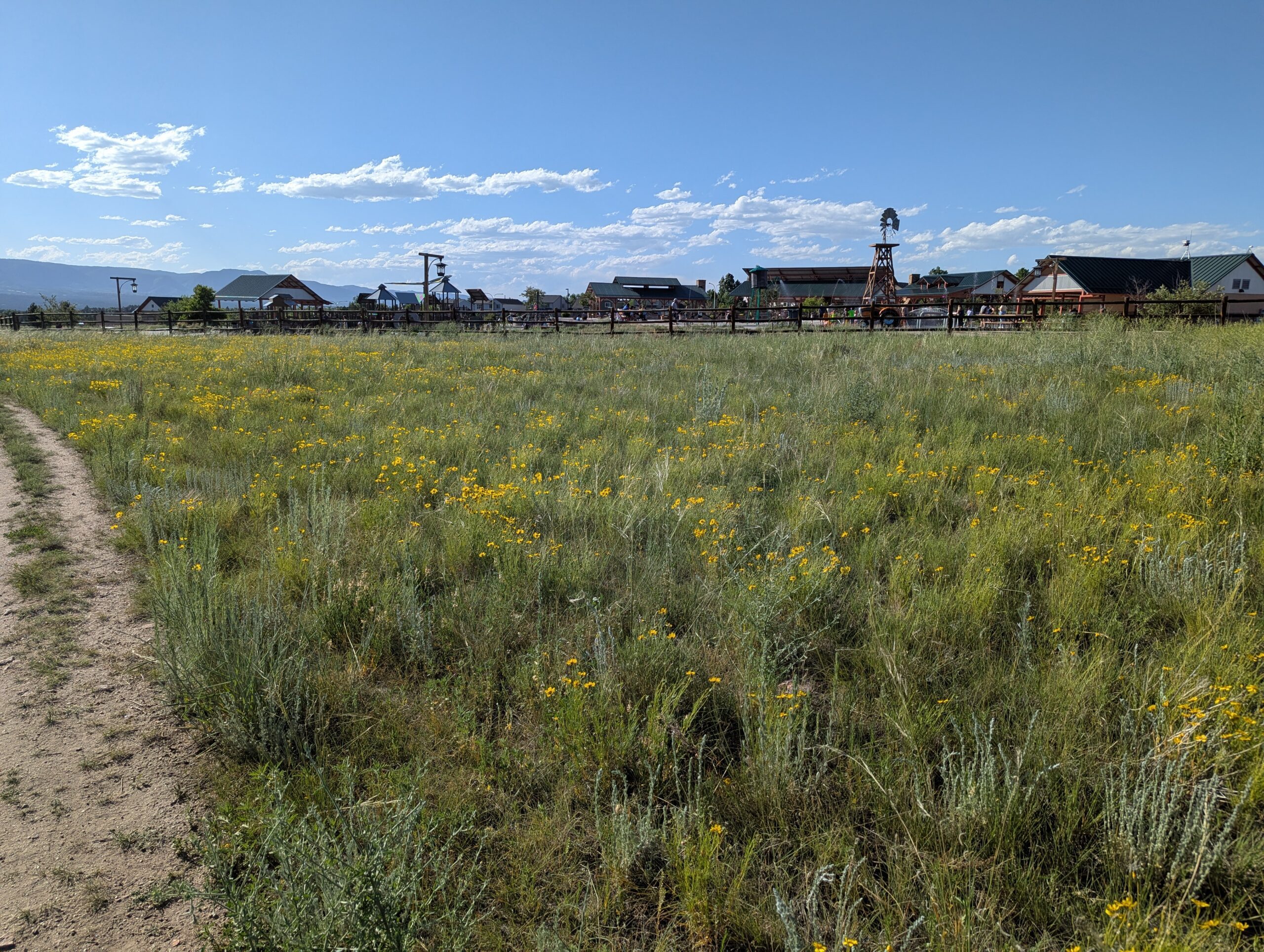
John Venezia Community Park is a 30-acre community gem located on the north side of Colorado Springs. Designed with families in mind, the park combines modern recreation facilities, natural landscaping, and open space to create a vibrant destination for all ages.
Trails and Recreation
The park features a network of walking and biking paths that wind through natural prairie landscapes and connect to nearby neighborhoods. Sports enthusiasts will find multipurpose athletic fields, basketball courts, and pickleball courts, while kids can enjoy one of the city’s most creative playgrounds—complete with climbing structures, slides, and shaded areas.
Amenities and Features
A highlight of the park is its water play area, which provides a refreshing way to cool off during the summer months. The park also includes picnic pavilions, restrooms, and wide-open green spaces ideal for community gatherings and family outings. Dog owners will appreciate the dog-friendly trails and areas designed for walking furry companions.
Wildlife & Scenery
Surrounded by the rolling prairies and open views of the Front Range, Venezia Park blends urban convenience with scenic charm. Native grasses, wildflowers, and stands of cottonwoods create a welcoming space for songbirds and other wildlife. The backdrop of Pikes Peak and the Rocky Mountains makes for a striking view while exploring the park.
History
Named after John Venezia, a former Colorado Springs City Council member and community leader, the park reflects his commitment to creating spaces that enhance quality of life. Opened in 2017, the park quickly became one of the most popular family destinations in the northern part of the city, filling a long-anticipated need for outdoor recreation in the growing community.
Plan Your Visit
Location: 3555 Briargate Parkway, Colorado Springs, CO 80920 Hours: April–October: 5:00 a.m. – 11:00 p.m. | November–March: 6:00 a.m. – 9:00 p.m. Parking: A large parking lot provides convenient access to all amenities, with additional neighborhood trail access points nearby.
Memorial Park
Memorial Park, one of the largest and most popular parks in Colorado Springs, is a true centerpiece of community life. Spanning 196 acres just east of downtown, it offers something for everyone—from outdoor recreation and scenic lake views to cultural events and family gatherings.
Trails and Recreation
The park is home to Prospect Lake, which features a 1.25-mile paved trail circling the water. Runners, walkers, and cyclists enjoy this route year-round, while nearby sports fields and courts support baseball, softball, basketball, tennis, and volleyball. The Sertich Ice Center, skate park, and fitness stations provide even more options for active recreation.
Amenities and Features
Memorial Park offers an impressive variety of amenities. Prospect Lake is open for fishing, swimming, paddleboarding, and boating during summer months. Families can enjoy modern playgrounds, picnic areas, and open lawns for gatherings. The park also hosts community events and festivals throughout the year, drawing thousands of residents and visitors.
Memorials
True to its name, Memorial Park honors service and sacrifice through several dedicated memorials. The Peace Officers Memorial pays tribute to law enforcement officers who have lost their lives in the line of duty. The International Association of Fire Fighters (IAFF) Fallen Fire Fighter Memorial honors professional firefighters from across the United States and Canada who made the ultimate sacrifice. Each September, thousands gather at this site for a solemn remembrance ceremony, making it a place of both mourning and pride for the firefighting community.
Wildlife & Scenery
Despite being in the heart of the city, the park provides a place to enjoy nature. Prospect Lake attracts ducks, geese, and other waterfowl, while mature shade trees and open lawns create a peaceful urban escape. Scenic mountain views from the west side of the park add to its beauty.
History
Memorial Park has long been a hub for recreation in Colorado Springs. Prospect Lake was originally a reservoir that became a recreation site for the growing city. Over the decades, the park has expanded and modernized, serving as a living reflection of the city’s investment in outdoor spaces and community wellness.
Plan Your Visit
Location: 1605 E Pikes Peak Avenue, Colorado Springs, CO 80910 Hours: April–October: 5:00 a.m. – 11:00 p.m. | November–March: 6:00 a.m. – 9:00 p.m. Parking: Multiple parking lots surround the park, with easy access to Prospect Lake, sports fields, memorials, and picnic areas.
Widefield Community Park
Widefield Community Park, located just south of Colorado Springs, is a vibrant community hub offering recreation for all ages. With its blend of athletic facilities, playgrounds, trails, and natural areas, this park provides a place where families, athletes, and nature lovers can all connect.
Trails and Recreation
The park includes multi-use trails for walking, running, and cycling, as well as sports fields for baseball, softball, and soccer. Basketball and tennis courts provide additional options for active recreation, while open spaces and shaded areas make it a great spot for casual outdoor activities. There is access to the Crews Gulch Trail.
Amenities and Features
Widefield Community Park is designed with families in mind. It features a modern playground, picnic shelters, and community gathering areas. The park’s athletic fields and courts are popular for both organized leagues and casual pickup games, while its open grassy spaces are perfect for community events and outdoor fun. One of the region’s best disc golf courses is in the park and allows for the opportunity to play along a seasonal creek and large cottonwoods.
Wildlife & Scenery
Though surrounded by neighborhoods, the park still supports local wildlife, including songbirds, squirrels, and the occasional deer passing through nearby creeks and open space. Mature trees provide shade and natural beauty, offering a refreshing landscape for both play and relaxation.
History
Widefield Community Park reflects the growth of the Widefield area as a suburban community in El Paso County. Developed to serve residents with recreational opportunities close to home, the park continues to evolve as a gathering place for families and neighbors, maintaining its role as a cornerstone of the community.
Plan Your Visit
Location: 704 Widefield Drive, Colorado Springs, CO 80911 Hours: April–October: 5:00 a.m. – 11:00 p.m. | November–March: 6:00 a.m. – 9:00 p.m. Parking: On-site parking lots provide easy access to playgrounds, fields, and picnic areas.
Fox Run Regional Park
Fox Run Regional Park, located in northern El Paso County near Black Forest, spans 417 acres of ponderosa pine forest, open meadows, and two picturesque lakes. A favorite for families, dog owners, and outdoor enthusiasts, the park blends natural beauty with well-designed amenities.
Trails and Recreation
The park offers about 4 miles of multi-use trails that weave through shaded pine stands and open areas, perfect for hiking, jogging, and biking. A scenic gazebo overlooking one of the lakes is a popular spot for quiet reflection or family photos.
Amenities and Features
Visitors will find two playgrounds, athletic fields, picnic pavilions, and large group shelters available by reservation. The park also features two fenced dog parks, making it a destination for pet owners. The combination of forests, ponds, and open fields makes Fox Run ideal for year-round outings.
Wildlife & Scenery
Fox Run’s lakes attract waterfowl such as ducks and geese, while the surrounding ponderosa pines provide habitat for woodpeckers, songbirds, squirrels, and deer. In the early morning or at dusk, it’s not uncommon to see herds of mule deer moving through the meadows. Seasonal wildflowers brighten the trails in spring and summer, while fall brings golden grasses and crisp air beneath towering pines.
History
Fox Run Regional Park opened in the late 1970s as one of El Paso County’s largest developed regional parks. Its creation helped meet the growing recreational needs of northern El Paso County as neighborhoods expanded around Black Forest. Today, it continues to serve as both a community gathering place and a natural retreat, preserving a slice of ponderosa pine forest amid rapid development.
Plan Your Visit
Location: 2110 Stella Drive, Colorado Springs, CO 80921 Hours: April–October: 5:00 a.m. – 9:00 p.m. | November–March: 6:00 a.m. – 6:00 p.m. Parking: Lots are accessible from Stella Drive and Roller Coaster Road, with spaces near playgrounds, fields, and trailheads.
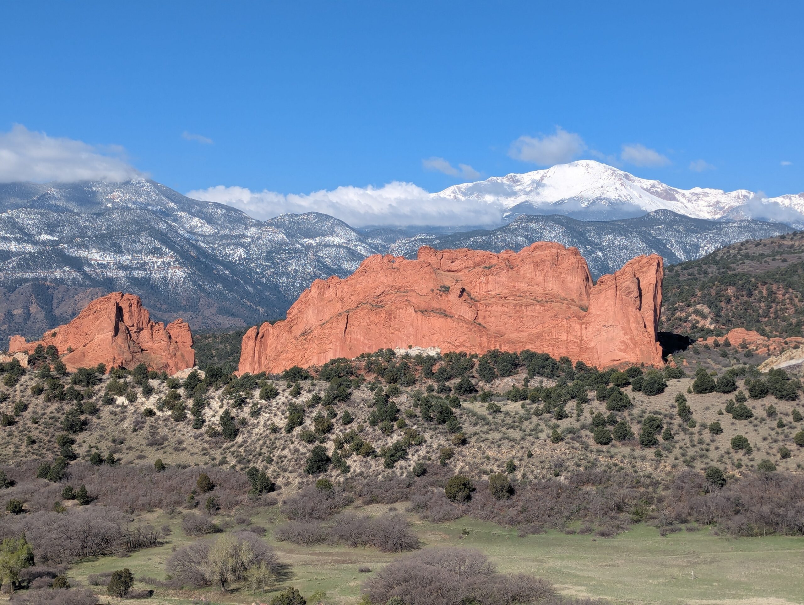
Garden of the Gods Park
Garden of the Gods Park is Colorado Springs’ crown jewel—a National Natural Landmark known worldwide for its towering red sandstone formations framed by Pikes Peak. With awe-inspiring geology, rich cultural history, and miles of trails, it is one of the most visited parks in the state and a must-see for residents and visitors alike.
Trails & Recreation
Garden of the Gods offers more than 21 miles of trails for hiking, running, biking, and horseback riding. The Perkins Central Garden Trail is a family-friendly, paved 1.5-mile loop with spectacular views of the park’s signature formations. Mountain bikers and equestrians can explore designated multi-use routes, while technical climbers come from around the globe to scale the sandstone spires (permit required).
Wildlife & Scenery
Mule deer, bighorn sheep, and red-tailed hawks are frequently seen among the towering rock formations. The park is also one of the best places to capture sunrise or sunset photography, when the sandstone glows against the backdrop of Pikes Peak and the Front Range.
History
The park’s striking formations began forming more than 300 million years ago, later uplifted and sculpted into their current dramatic shapes. In 1909, Charles Elliott Perkins’ children honored his wishes to donate the land to the City of Colorado Springs, ensuring that the park would remain “free to the world.” Today, Garden of the Gods continues to inspire millions each year with its blend of geology, history, and natural beauty.
Plan Your Visit
Location: 1805 N. 30th Street, Colorado Springs, CO 80904 Hours: Open daily, 5:00 a.m. – 9:00 p.m. (summer) and 5:00 a.m. – 7:00 p.m. (winter) Parking & Access: Multiple lots are available throughout the park. The Visitor & Nature Center, located across from the main entrance, offers free exhibits, maps, and educational programs. Tips: Arrive early to beat crowds, especially on weekends. Dogs are welcome on leash, and rock climbing requires registration and proper gear. Stop at the Garden of the Gods Visitor Center to see maps, interpretive displays, use the restrooms and grab food & souvenirs. More Information: https://gardenofgods.com/
With its dramatic landscapes, deep cultural roots, and abundant recreational opportunities, Garden of the Gods Park is a one-of-a-kind outdoor treasure in the Pikes Peak region.
Cottonwood Creek Park
Cottonwood Creek Park is one of the largest community parks in northeast Colorado Springs, offering more than 70 acres of recreation and open space. This popular destination combines athletic facilities, playgrounds, trails, and wide open lawns, making it a hub for families, athletes, and anyone looking to enjoy the outdoors in the heart of the city.
Amenities and Recreation
The park features a wide variety of facilities, including:
Cottonwood Creek Recreation Center with an indoor pool, gymnasium, and fitness classes.
Sports fields for soccer, football, and baseball.
Tennis courts, basketball courts, and a skate park.
Playgrounds and picnic areas perfect for families.
Dog park where pups can run off-leash.
Trails and Natural Features
A paved section of the Cottonwood Creek Trail runs through the park, connecting to the larger Pikes Peak Greenway Trail system. The trail is popular with walkers, cyclists, and runners, offering a scenic corridor along the creek with mountain views to the west. Open fields and shady spots make it a great place to enjoy nature without leaving the city.
Location and Access
Address: 3920 Dublin Blvd, Colorado Springs, CO 80918
Parking: Multiple paved lots are available around the park and recreation center, with ADA-accessible spaces. Parking is free.
Hours: The park is open daily from 5:00 a.m. to 11:00 p.m.; recreation center hours vary seasonally.
With its blend of recreation facilities, community events, and natural beauty, Cottonwood Creek Park is a top destination for families, athletes, and trail users in Colorado Springs.
Woodmen Trail – Colorado Springs, CO
Woodmen Trail is a neighborhood focused urban trail in northern Colorado Springs that provides an important east west connection through the Briargate area. Following a powerline corridor, this paved trail offers a convenient option for walking, running, biking, and everyday recreation for nearby residents.
Trail Experience
Woodmen Trail is approximately 2.5 miles long and is constructed of smooth concrete. The trail runs east to west between Woodmen Road and Briargate Boulevard, beginning just west of Austin Bluffs Parkway and extending to just past Union Boulevard. Rolling hills along the corridor create noticeable elevation gain and loss, giving the trail a moderate rating despite its relatively short length.
The trail is popular with local users, is stroller friendly, and includes several benches along the route for resting and enjoying the surroundings. Wildflowers fill the fields around the trail in late summer.
Road Crossings and Safety
Users should expect a mix of neighborhood street crossings and larger roadway crossings along Woodmen Trail. Major crossings include Union Boulevard, Rangewood Drive, and Lexington Drive. The Union Boulevard crossing is accessed via the signalized intersection at Briargate Boulevard. Rangewood Drive includes a marked crosswalk, though vehicles may not consistently yield. Lexington Drive features a signalized pedestrian crossing.
Connections
Woodmen Trail transitions into Skyline Trail near the intersection of Briargate Boulevard and Union Boulevard, where the route shifts north. An unmarked connection to Briargate Trail occurs near Yellowwood Drive, allowing users to continue north. Multiple neighborhood access points are available along the length of the trail.
Management
Woodmen Trail is managed by the City of Colorado Springs Parks, Recreation and Cultural Services Department. Phone: 719 385 5940
Templeton Gap Trail – Colorado Springs, CO
Templeton Gap Trail is an important east west multi use trail in central Colorado Springs that follows the Templeton Gap Floodway. The trail provides a key connection between neighborhoods, parks, open spaces, and several major trail corridors, making it a popular route for both recreation and transportation.
Trail Experience
Templeton Gap Trail is approximately 4 miles long and runs primarily east to west alongside the Templeton Gap Floodway. The trail begins near Mark Dabling Boulevard at the Goose Gossage Youth Sports Complex and continues west to Palmer Park, with a northern fork extending toward Union Meadows Open Space near Austin Bluffs Boulevard and Union Boulevard.
The trail surface is primarily concrete, with some sections of asphalt and gravel. Elevation changes are generally mild, though users should expect a few moderate hills along the route.
Road Crossings and Navigation
Templeton Gap Trail includes several street crossings, including a major crossing at North Nevada Avenue. A short discontinuity exists near North Hancock Avenue by Portal Park. The trail runs on both sides of the floodway; however, to pass under Union Boulevard near Hancock Avenue, it is recommended to remain on the south side of the floodway for a more continuous route.
Connections
Templeton Gap Trail connects directly to the Pikes Peak Greenway at Goose Gossage Youth Sports Complex. From this location, users can also access Sinton Trail to continue west. On the eastern end, the trail links to Austin Bluffs Trail near North Union Boulevard, providing access toward the University of Colorado Colorado Springs campus. Additional connections include Greencrest Trail into Palmer Park and easy access to Union Meadows Open Space.
Cottonwood Creek Trail – Colorado Springs, CO
Cottonwood Creek Trail is a major east west urban trail in northern Colorado Springs and a key connector within the city’s trail system. Following Cottonwood Creek, the trail links neighborhoods, parks, and regional trail corridors while providing a smooth and accessible route for everyday recreation and transportation.
Location: Northern Colorado Springs, following Cottonwood Creek from Powers Boulevard to the Pikes Peak Greenway near I 25
Trail Experience
Cottonwood Creek Trail is just over 6 miles long and features a smooth concrete surface throughout. The trail runs east to west along Cottonwood Creek, beginning near Frank Castello Park at Powers Boulevard and continuing west to connect with the Pikes Peak Greenway and Front Range Trail near I 25.
The trail is generally flat with gentle elevation changes, making it accessible for walkers, runners, cyclists, families, and users of mobility devices. The corridor offers a mix of riparian habitat, open space, and neighborhood views, with long straight segments that are well suited for longer outings or commuting. Benches, trail access points, and nearby amenities allow users to easily tailor trips to their preferred distance and pace.
A dirt trail alternative runs between Union Boulevard and Rangewood Drive, providing a more natural surface option and forming a pleasant 3 mile loop with convenient parking at Cottonwood Creek Community Park.
Road Crossings and Navigation
Cottonwood Creek Trail includes one major street crossing at Union Boulevard. Trail users should use the marked crosswalk at Woodland Hills Drive when crossing Union Boulevard. The trail passes alongside Frank Castello Park and includes a spur connection to Dublin Park; however, accessing Dublin Park requires crossing Dublin Boulevard, which currently does not have a designated pedestrian crossing.
Connections
Cottonwood Creek Trail connects directly to the Pikes Peak Greenway and Front Range Trail just south of the Woodmen Road and Rockrimmon Boulevard area. Multiple neighborhood access points provide easy connections to Cottonwood Creek Community Park, nearby residential areas, and the YMCA. The trail also links to Woodmen Trail and other local trail segments, strengthening north south and east west connectivity across northern Colorado Springs.
Skyline Trail – Colorado Springs, CO
Skyline Trail is a neighborhood focused urban trail in northern Colorado Springs that provides an important north south connection through the Briargate area. Often referred to locally as the Powerline Trail due to its alignment with overhead powerlines, Skyline Trail is well used by nearby residents for walking, running, and biking.
Skyline Trail is approximately 2 miles long and features a mix of wide concrete and dirt trail surfaces. South of Research Parkway, the trail is smooth concrete, while the segment north of Research Parkway transitions to a dirt surface. Rolling terrain creates noticeable elevation gain and loss, giving the trail a moderate difficulty rating.
The trail includes several distinctive switchbacks near Mirage Drive that offer views across the surrounding neighborhoods and open spaces. Despite its urban setting, the corridor provides a sense of separation from nearby roads and is popular for short neighborhood outings as well as longer connected trips.
Road Crossings and Navigation
Skyline Trail includes several street crossings and users should proceed with caution at all crosswalks. Major crossings occur at Briargate Boulevard and Research Parkway. When crossing Research Parkway, users should use the signalized intersection at Chapel Hills Drive for improved safety. Trail signage varies by segment, and awareness is recommended when navigating transitions between surfaces.
Connections
Skyline Trail transitions into Woodmen Trail at Briargate Boulevard, allowing users to continue east west through northern Colorado Springs. A spur trail provides access to Rampart Community Park, which includes a disc golf course, sports courts and fields, and a dog park. The trail passes near High Plains Elementary School and offers views of Reflection Pond, which can be accessed via sidewalks on Parliament Drive.
Sidewalk connections along Briargate Parkway allow access to John Venezia Community Park and the Briargate Trail. Multiple neighborhood access points along the route make Skyline Trail easy to reach from surrounding residential areas.
Skyline Trail plays an important role in connecting neighborhoods, parks, and trails across northern Colorado Springs while offering a moderately challenging route with varied terrain and strong local use.