The Palmer Mesa Trail is a multiuse pathway in Colorado Springs that spans approximately 3.5 miles of paved and unpaved surface along Mesa Road. Beginning in Blair Bridge Open Space, the trail branches off from the Foothills Trail and travels south through scenic foothills and neighborhood landscapes.
Recreation
This trail is popular with walkers, runners, cyclists, and families looking for a moderate, accessible route with strong scenic rewards. Its mix of paved and natural surface makes it suitable for both casual outings and longer fitness-focused trips. The gentle grades and open views make it especially enjoyable for sunset walks and rides.
Trails and Connections
Palmer Mesa Trail begins at Blair Bridge Open Space and connects to the Foothills Trail before continuing south along Mesa Road. Near its midpoint, the route intersects with the Mesa Valley Trail at Oliver Wendell Holmes Middle School. These connections allow users to build longer routes linking multiple west-side trail systems.
Wildlife and Scenery
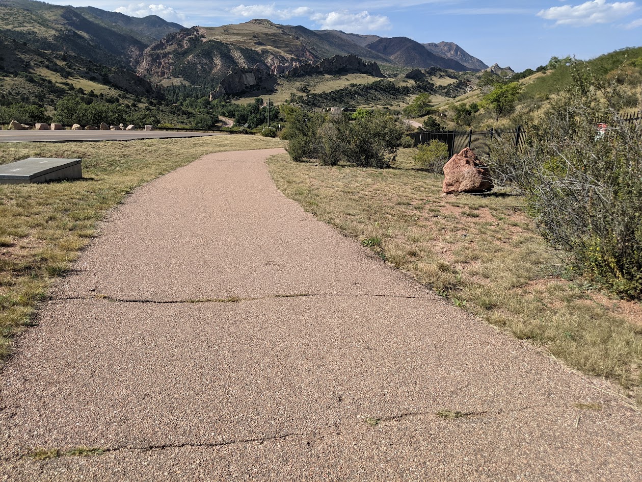
Highlights along the trail include overlooks of the striking red sandstone formations and rolling hills of Garden of the Gods. A stone arch bridge built by John Blair, landscape gardener for the Glen Eyrie estate, adds historic character to the route. Open foothills terrain and native vegetation create changing scenery throughout the year.
History
The trail corridor reflects the area’s connection to early landscape design associated with the Glen Eyrie estate and surrounding foothills. Features such as the stone arch bridge and scenic viewpoints highlight the blend of natural beauty and historic influence along Mesa Road.
Plan Your Visit
Location: Along Mesa Road, from Blair Bridge Open Space to Mesa Valley Trail Parking: Small parking areas near the Blair Bridge. Hours: Open daily, sunrise to sunset Fees: Free
Tips: Parking is limited and fills quickly during peak times, especially at sunset. Bring water, use caution near road crossings, and share the trail courteously with other users.
Rockrimmon Trail
The Rockrimmon Trail is a scenic urban foothills route in northwest Colorado Springs, offering sweeping views of the city, the Front Range, and surrounding open spaces. Popular with hikers, trail runners, and dog walkers, this accessible trail provides a quick escape into nature without leaving town.
Recreation
Rockrimmon Trail is well-suited for walking, jogging, and light trail running, with moderate elevation gain and open terrain. The route is frequently used for fitness outings, sunset walks, and casual nature exploration, making it a favorite for nearby neighborhoods. Leashed dogs are welcome, and the trail’s wide sections make it comfortable for shared use.
Trails and Connections
The main trail connects to a network of nearby routes in the Rockrimmon and Peregrine open space areas, allowing users to extend their outings. Hikers can link to additional foothills trails for longer loops and more challenging terrain, creating flexible options for both short and extended visits.
Wildlife and Scenery
The trail passes through grasslands, shrublands, and rocky outcrops that support deer, hawks, songbirds, and other urban wildlife. Expansive views of Pikes Peak, Garden of the Gods, and the city skyline make this area especially popular for photography and quiet reflection.
History
The Rockrimmon area has long been valued for its natural setting along the city’s western edge. As development expanded nearby, the trail system was preserved to maintain public access to foothills landscapes and outdoor recreation close to residential neighborhoods.
Plan Your Visit
Location: Northwest Colorado Springs, near Rockrimmon Boulevard Parking: Limited street parking available near trailheads Hours: Open daily, sunrise to sunset Fees: Free Tips: Bring water, sun protection, and sturdy shoes. Watch for changing weather and share the trail courteously with other users.
With its convenient location, open views, and connections to surrounding open spaces, Rockrimmon Trail offers an easy and rewarding way to experience the foothills and stay active close to home.
Rock Island Regional Trail – Falcon and Peyton, CO
East of Colorado Springs, the Rock Island Regional Trail continues through Falcon and Peyton along the same historic railroad alignment. This segment provides a more rural experience, connecting growing communities and open landscapes while preserving the legacy of the former rail corridor.
Location: Eastern El Paso County, between Falcon and Peyton along the former Rock Island Railroad corridor
Trail Experience
The Falcon and Peyton segment of the Rock Island Trail offers a quieter, more open setting compared to the urban Colorado Springs portion. The trail follows the historic rail bed through prairie landscapes and developing residential areas, creating opportunities for walking, biking, and horseback riding depending on surface conditions.
As development continues in eastern El Paso County, this segment plays an increasingly important role in providing off street trail access and connecting communities to regional recreation opportunities.
Connections
The Falcon and Peyton portion of the Rock Island Trail connects local neighborhoods and open spaces while supporting long term plans for expanded trail connectivity across eastern El Paso County. Future trail extensions and connections are expected to further link this corridor to parks, schools, and regional trail systems.
The Rock Island Trail reflects Colorado Springs’ rail history while serving as a vital recreation and transportation corridor today. Together, the urban and eastern segments illustrate how historic infrastructure continues to shape access, connectivity, and community across the region.
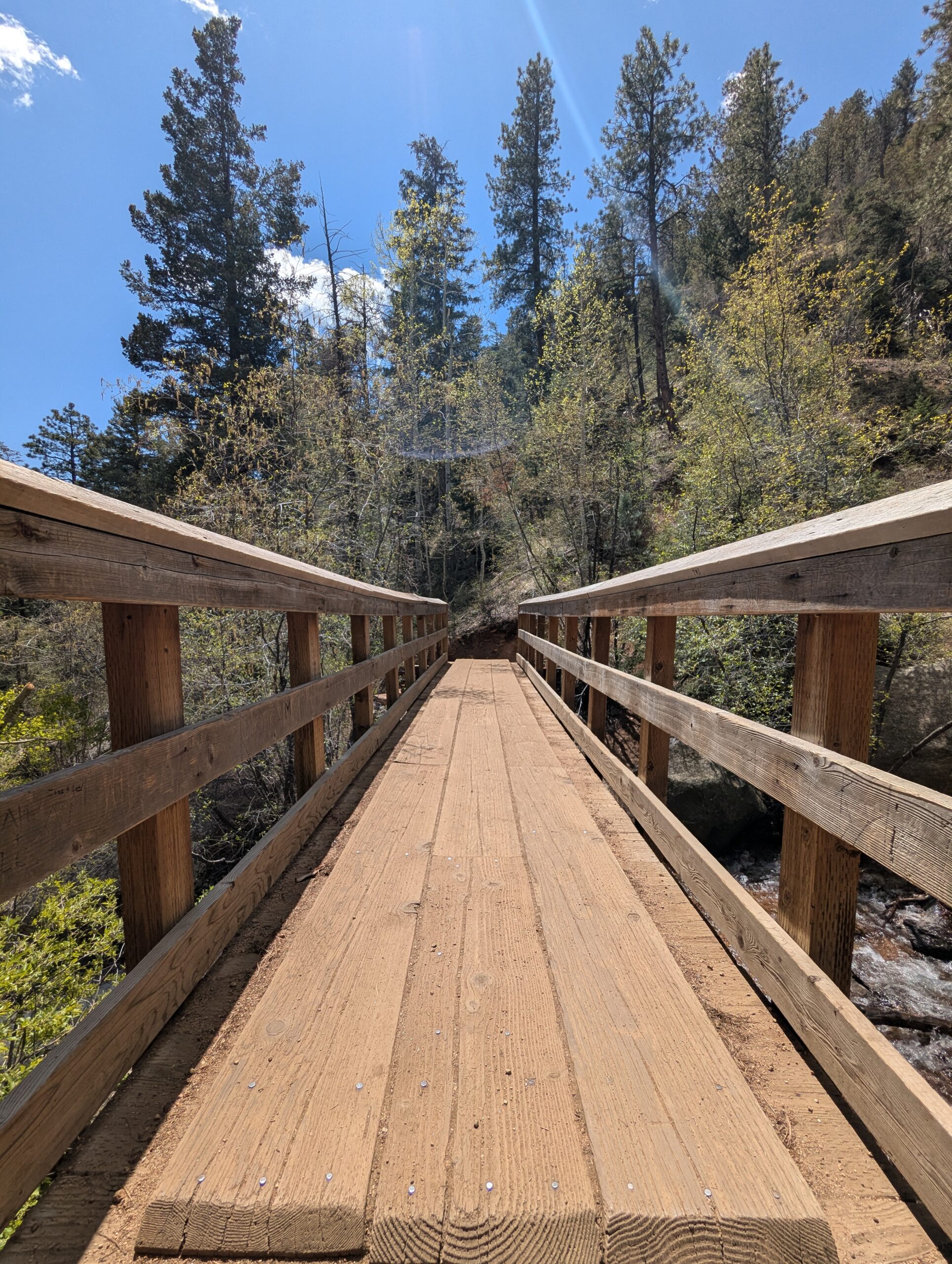
The Seven Bridges Trail, also known as Trail #622, is one of the most popular hikes in North Cheyenne Cañon. This moderate trail is about 3.7 miles round trip and gains roughly 1,000 feet in elevation as it follows North Cheyenne Creek. Its charm comes from crossing seven rustic wooden bridges that give the trail its name, making it a family-friendly adventure with plenty of photo opportunities.
Trails and Recreation
The trail begins at the end of North Cheyenne Canyon Road near the parking area for the Upper Gold Camp Road. From there, hikers follow a steady incline along a shaded canyon trail, crossing over seven picturesque wooden bridges. Beyond the seventh bridge, the path continues into steeper terrain and can be extended to connect with higher trails like Jones Park or Mount Rosa for those looking for a longer trek.
Wildlife and Scenery
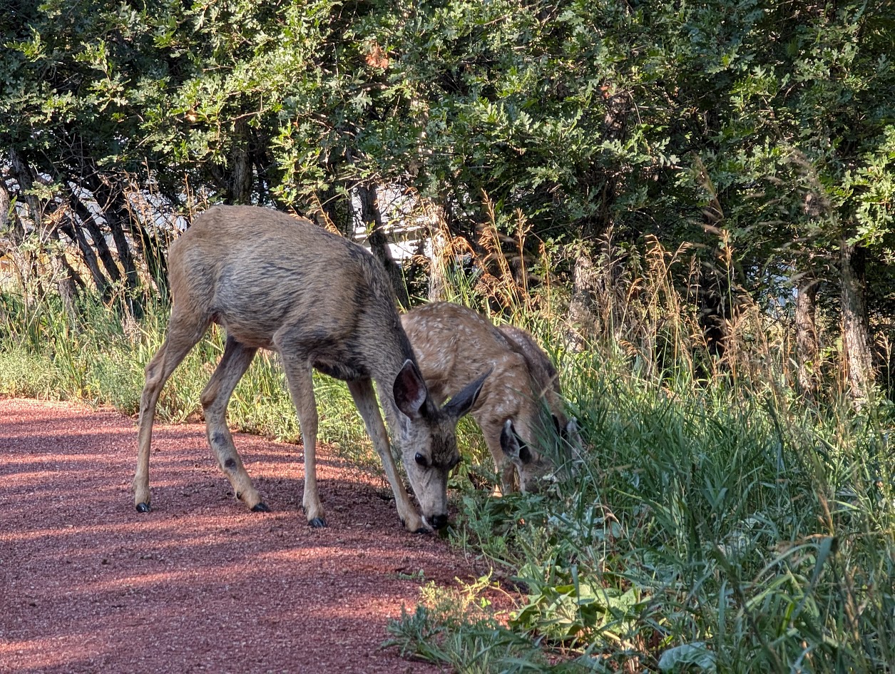
Surrounded by towering evergreens, mountain streams, and granite walls, the Seven Bridges Trail offers classic Front Range beauty. Depending on the season, hikers may encounter wildflowers, colorful autumn foliage, or sparkling ice formations along the creek. Wildlife is common in the area—mule deer, songbirds, and the occasional black bear may be spotted in the canyon.
History
The trail follows an old pipeline route that once carried water from the mountains into Colorado Springs in the early 20th century. The bridges were originally constructed to maintain access along the pipeline, and today they remain a beloved feature of this historic route.
Plan Your Visit
Location: Trailhead parking is located at the end of North Cheyenne Canyon Road, just past the closed Gold Camp Road tunnel. Parking: A paved lot is available, but it fills quickly—arrive early, especially on weekends. Additional parking may be available further down the road. Hours: Open daily, 5:00 a.m. – 9:00 p.m. Tips:
The trail is well-shaded, making it a great summer hike.
Dogs are welcome but must be leashed.
Wear sturdy shoes, as the path can be rocky and icy in colder months.
Continue past the seventh bridge if you want to extend your hike into the higher country of Pike National Forest.
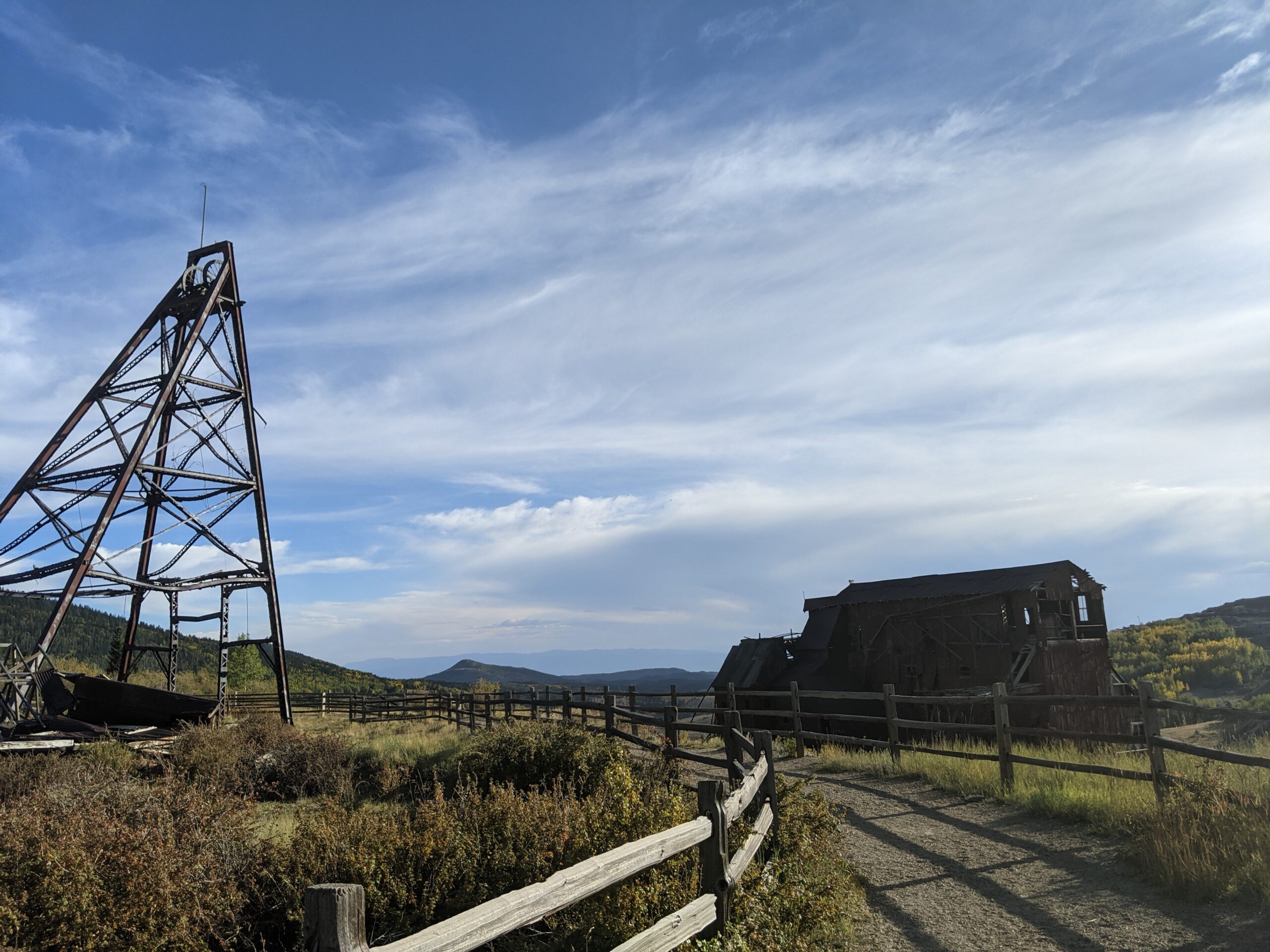
Vindicator Valley Trail
Vindicator Valley Trail in Victor, Colorado, offers a fascinating blend of outdoor recreation, mining history, and scenic beauty in the heart of the Cripple Creek & Victor Mining District. This interpretive loop trail winds through historic mining structures and reclaimed landscapes, giving visitors a glimpse into Colorado’s Gold Rush era while showcasing views of Pikes Peak and the rugged hills of Teller County.
Trails and Recreation
The Vindicator Valley Trail is a 2-mile loop that is rated easy to moderate, making it accessible for most hikers, families, and history enthusiasts. Along the way, you’ll find interpretive signs explaining the mining operations, equipment, and the lives of the people who once worked the area. The trail is popular year-round for hiking, snowshoeing, and photography.
Wildlife and Scenery
While the mining remnants are the highlight, the surrounding landscape is equally striking. Wildflowers bloom in summer, while fall brings golden aspens and crisp mountain air. Mule deer, elk, foxes, and a variety of bird species can often be spotted along the trail. Panoramic views of the Sangre de Cristo and Sawatch mountain ranges add to the experience.
History
Vindicator Valley sits in the heart of the Cripple Creek & Victor Gold Mining District, one of the most productive gold mining areas in the United States during the late 1800s and early 1900s. The trail passes by the historic Vindicator Mine and other structures that once fueled Colorado’s mining boom. Many of these wooden headframes and buildings have been stabilized to preserve them as open-air museums, allowing visitors to connect directly with the region’s past.
Plan Your Visit
Location: Trailhead located just north of Victor, CO off County Road 81 (about 45 minutes west of Colorado Springs). Parking: A gravel lot is available at the trailhead. Parking is free but limited. Hours: Open daily, year-round, from dawn to dusk. Tips:
Interpretive signage is plentiful—allow time to read and explore.
Bring water and sun protection; shade is limited.
Winter visits may require traction devices or snowshoes.
Respect historic structures by staying on designated trails.
Woodmen Trail – Colorado Springs, CO
Woodmen Trail is a neighborhood focused urban trail in northern Colorado Springs that provides an important east west connection through the Briargate area. Following a powerline corridor, this paved trail offers a convenient option for walking, running, biking, and everyday recreation for nearby residents.
Trail Experience
Woodmen Trail is approximately 2.5 miles long and is constructed of smooth concrete. The trail runs east to west between Woodmen Road and Briargate Boulevard, beginning just west of Austin Bluffs Parkway and extending to just past Union Boulevard. Rolling hills along the corridor create noticeable elevation gain and loss, giving the trail a moderate rating despite its relatively short length.
The trail is popular with local users, is stroller friendly, and includes several benches along the route for resting and enjoying the surroundings. Wildflowers fill the fields around the trail in late summer.
Road Crossings and Safety
Users should expect a mix of neighborhood street crossings and larger roadway crossings along Woodmen Trail. Major crossings include Union Boulevard, Rangewood Drive, and Lexington Drive. The Union Boulevard crossing is accessed via the signalized intersection at Briargate Boulevard. Rangewood Drive includes a marked crosswalk, though vehicles may not consistently yield. Lexington Drive features a signalized pedestrian crossing.
Connections
Woodmen Trail transitions into Skyline Trail near the intersection of Briargate Boulevard and Union Boulevard, where the route shifts north. An unmarked connection to Briargate Trail occurs near Yellowwood Drive, allowing users to continue north. Multiple neighborhood access points are available along the length of the trail.
Management
Woodmen Trail is managed by the City of Colorado Springs Parks, Recreation and Cultural Services Department. Phone: 719 385 5940
Templeton Gap Trail – Colorado Springs, CO
Templeton Gap Trail is an important east west multi use trail in central Colorado Springs that follows the Templeton Gap Floodway. The trail provides a key connection between neighborhoods, parks, open spaces, and several major trail corridors, making it a popular route for both recreation and transportation.
Trail Experience
Templeton Gap Trail is approximately 4 miles long and runs primarily east to west alongside the Templeton Gap Floodway. The trail begins near Mark Dabling Boulevard at the Goose Gossage Youth Sports Complex and continues west to Palmer Park, with a northern fork extending toward Union Meadows Open Space near Austin Bluffs Boulevard and Union Boulevard.
The trail surface is primarily concrete, with some sections of asphalt and gravel. Elevation changes are generally mild, though users should expect a few moderate hills along the route.
Road Crossings and Navigation
Templeton Gap Trail includes several street crossings, including a major crossing at North Nevada Avenue. A short discontinuity exists near North Hancock Avenue by Portal Park. The trail runs on both sides of the floodway; however, to pass under Union Boulevard near Hancock Avenue, it is recommended to remain on the south side of the floodway for a more continuous route.
Connections
Templeton Gap Trail connects directly to the Pikes Peak Greenway at Goose Gossage Youth Sports Complex. From this location, users can also access Sinton Trail to continue west. On the eastern end, the trail links to Austin Bluffs Trail near North Union Boulevard, providing access toward the University of Colorado Colorado Springs campus. Additional connections include Greencrest Trail into Palmer Park and easy access to Union Meadows Open Space.
Skyline Trail – Colorado Springs, CO
Skyline Trail is a neighborhood focused urban trail in northern Colorado Springs that provides an important north south connection through the Briargate area. Often referred to locally as the Powerline Trail due to its alignment with overhead powerlines, Skyline Trail is well used by nearby residents for walking, running, and biking.
Skyline Trail is approximately 2 miles long and features a mix of wide concrete and dirt trail surfaces. South of Research Parkway, the trail is smooth concrete, while the segment north of Research Parkway transitions to a dirt surface. Rolling terrain creates noticeable elevation gain and loss, giving the trail a moderate difficulty rating.
The trail includes several distinctive switchbacks near Mirage Drive that offer views across the surrounding neighborhoods and open spaces. Despite its urban setting, the corridor provides a sense of separation from nearby roads and is popular for short neighborhood outings as well as longer connected trips.
Road Crossings and Navigation
Skyline Trail includes several street crossings and users should proceed with caution at all crosswalks. Major crossings occur at Briargate Boulevard and Research Parkway. When crossing Research Parkway, users should use the signalized intersection at Chapel Hills Drive for improved safety. Trail signage varies by segment, and awareness is recommended when navigating transitions between surfaces.
Connections
Skyline Trail transitions into Woodmen Trail at Briargate Boulevard, allowing users to continue east west through northern Colorado Springs. A spur trail provides access to Rampart Community Park, which includes a disc golf course, sports courts and fields, and a dog park. The trail passes near High Plains Elementary School and offers views of Reflection Pond, which can be accessed via sidewalks on Parliament Drive.
Sidewalk connections along Briargate Parkway allow access to John Venezia Community Park and the Briargate Trail. Multiple neighborhood access points along the route make Skyline Trail easy to reach from surrounding residential areas.
Skyline Trail plays an important role in connecting neighborhoods, parks, and trails across northern Colorado Springs while offering a moderately challenging route with varied terrain and strong local use.
Sinton Trail – Colorado Springs, CO
Sinton Trail is a scenic urban trail in central Colorado Springs that follows Douglas Creek and an adjacent drainage canal. The trail offers a peaceful corridor through an otherwise developed area, connecting major trail systems while providing opportunities to experience wildlife, seasonal color, and quiet open space close to the city.
Location: Central Colorado Springs, between Garden of the Gods Road and Mark Dabling Boulevard
Trail Experience
Sinton Trail is approximately 3 miles long and runs northwest to southeast between Garden of the Gods Road and Mark Dabling Boulevard, just north of the Goose Gossage Youth Sports Complex. The trail surface is primarily asphalt, with short sections of concrete and gravel. Elevation changes are gradual, with a gentle uphill grade when traveling west.
The trail is well suited for walking, running, and biking and is accessible to a wide range of users. One of the highlights of the trail is its proximity to water and riparian habitat, which supports birdwatching opportunities, particularly near Sinton Pond Open Space. Waterfowl, songbirds, and other wildlife are commonly observed in this area.
In autumn, mature cottonwoods and other trees along the corridor provide vibrant fall color, making Sinton Trail especially popular during the changing seasons. The combination of water, vegetation, and separation from traffic creates a calm and immersive trail experience.
Road Crossings and Navigation
Sinton Trail includes two at grade street crossings at North Chestnut Road and Holland Park Boulevard. The trail also passes under Centennial Boulevard via a narrow metal tunnel, which requires users to proceed with caution and be aware of oncoming traffic, particularly cyclists.
Connections
Sinton Trail connects directly to the Pikes Peak Greenway and Templeton Gap Trail, making it an important link within Colorado Springs’ urban trail network. With minimal use of sidewalks and local streets, users can also reach 30th Street to connect with the Foothills Trail and Garden of the Gods Park.
A short dirt path provides access to Sinton Pond Open Space, a 13 acre natural area that offers a quiet detour and additional wildlife viewing opportunities within a densely developed part of the city.
Sinton Trail serves as both a functional connector and a natural refuge, offering year round recreation, seasonal beauty, and access to some of Colorado Springs’ most popular trail corridors.
Shooks Run Trail – Colorado Springs, CO
Shooks Run Trail is a central Colorado Springs urban trail that follows Shooks Run Creek through historic neighborhoods, community spaces, and growing arts and garden corridors. The trail provides an easy, accessible route for walking, biking, and everyday recreation while connecting several key trail systems and local destinations.
Location: Central and southeast Colorado Springs, following Shooks Run Creek from Lilac Street to Fountain Boulevard
Trail Experience
Shooks Run Trail is approximately 4 miles long and runs north to south along Shooks Run Creek. The trail begins near Lilac Street and the Rock Island Trail in the north and continues south to Fountain Boulevard and South Shooks Run Park. The paved surface makes for an easy walk or ride, with a slight downhill grade when traveling south.
The trail is well suited for all ages and abilities, with benches and picnic tables placed along the route for rest and gathering. Shooks Run passes through residential areas and community focused spaces, creating a neighborhood oriented experience that blends everyday use with access to nature. Several street crossings occur along the trail, so users should proceed with awareness at intersections. Several parks can be found along or near the trail.
History and Character
One of the defining features of Shooks Run Trail is its connection to Colorado Springs’ early rail history. At the southern end of the trail, users pass through a historic rail underpass built in 1887, a reminder of the city’s industrial and transportation roots. Beyond the underpass, the trail reaches the Concrete Coyote property, owned and stewarded by Concrete Couch, which has become a hub for community creativity and placemaking.
Connections
Shooks Run Trail connects directly to the Rock Island Trail, expanding access to north south travel across the city. Sidewalks and neighborhood streets provide frequent access points along the route, making the trail easy to reach from surrounding homes and businesses.
With limited on street or sidewalk travel, users can connect to the Pikes Peak Greenway, further linking Shooks Run into the broader Front Range trail network. The trail also passes near Pikes Peak Urban Gardens and the Sustain a Center, where the Trails and Open Space Coalition office is located just off the corridor.
Shooks Run Trail plays an important role in connecting neighborhoods, supporting local community spaces, and strengthening the urban trail network in Colorado Springs. It is a trail built for everyday use, local connection, and continued investment in accessible outdoor spaces.