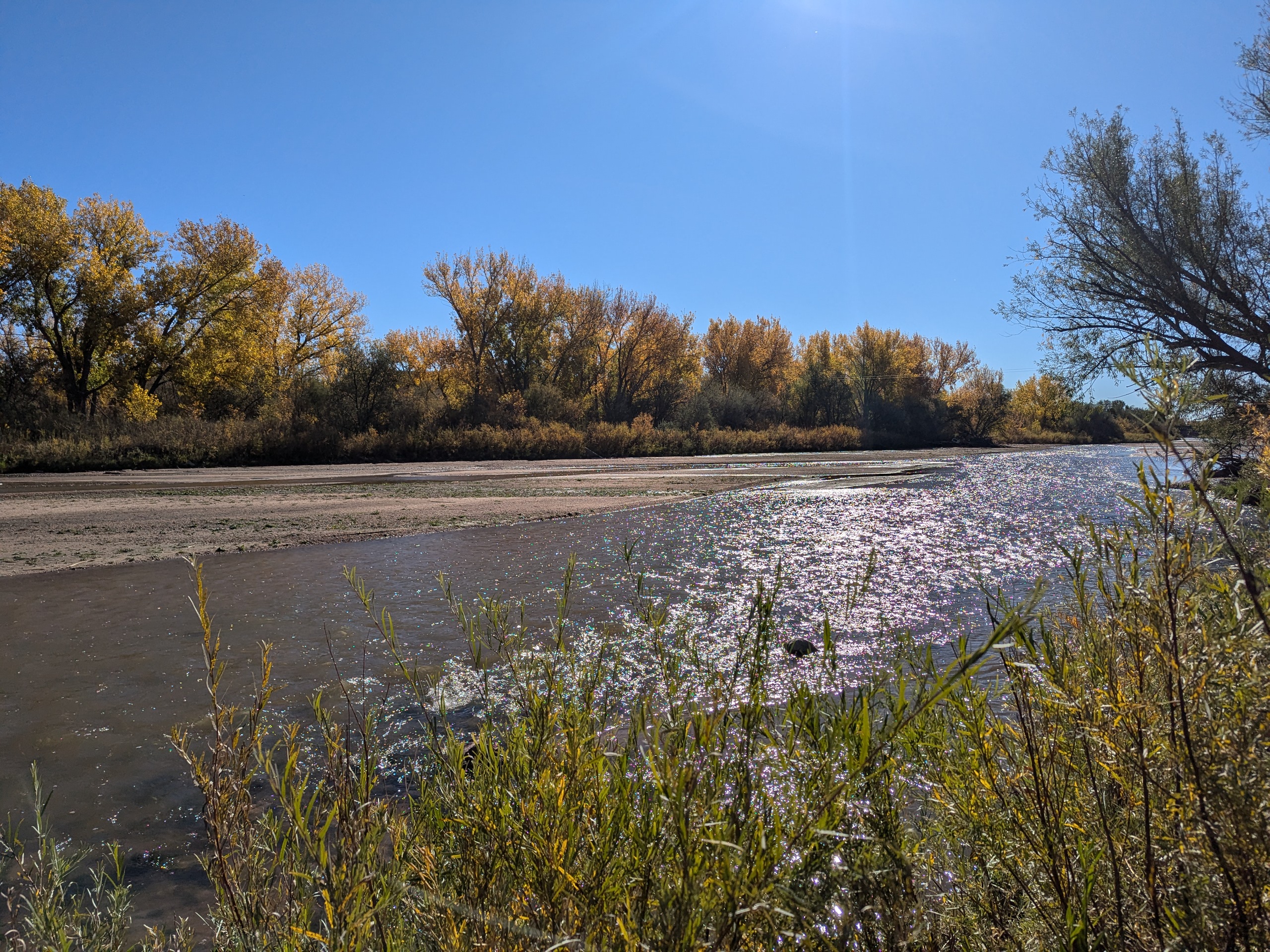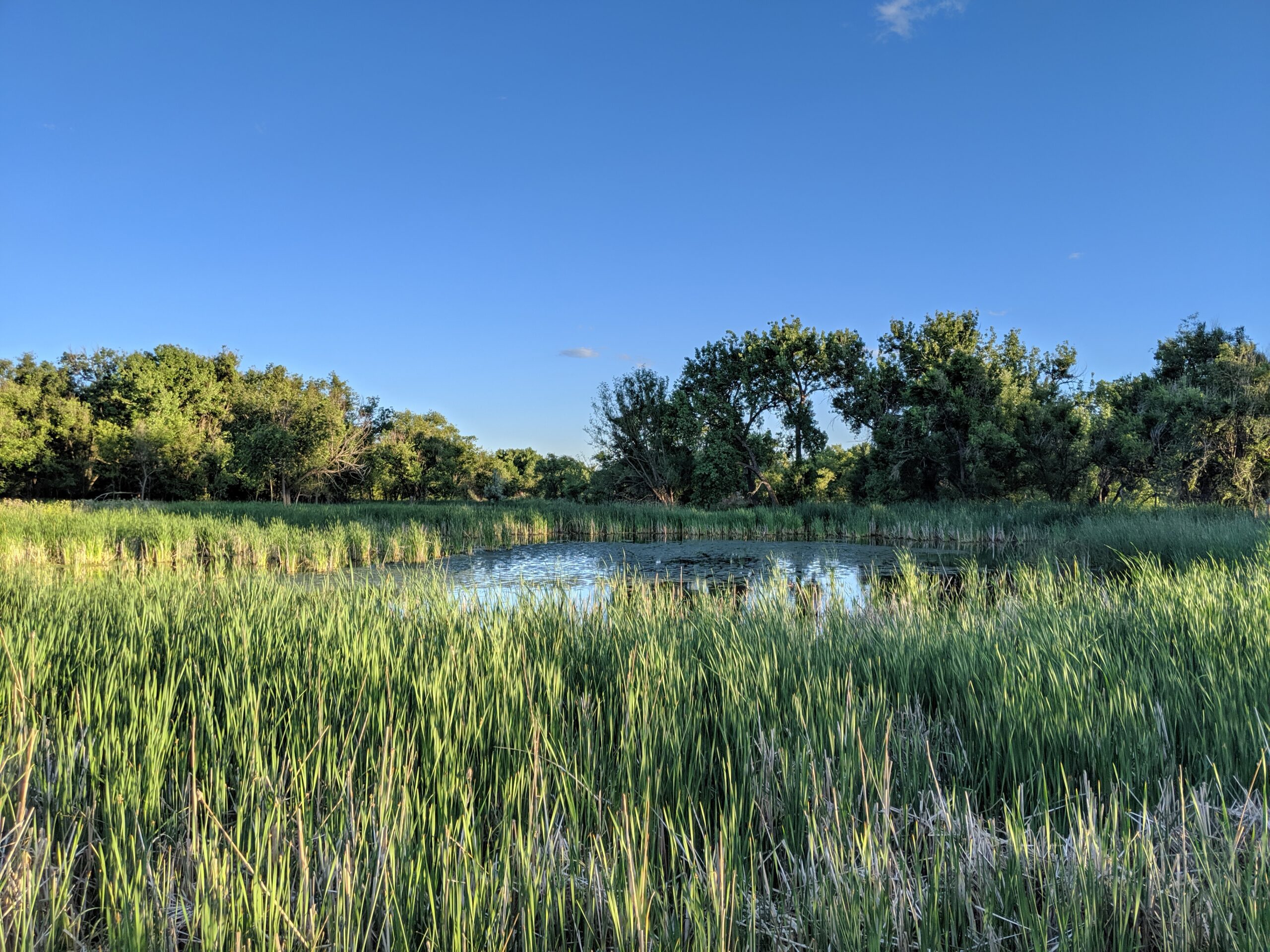
Cattail Marsh Wildlife Area
Cattail Marsh Wildlife Area in Fountain, CO is a quiet oasis tucked along the banks of Fountain Creek, offering one of the region’s best spots for birdwatching and nature observation. This wetland habitat, shaped by cattails, marsh grasses, and open water, provides an essential refuge for migratory birds and local wildlife while giving visitors a peaceful place to connect with nature.
Trails and Recreation
Visitors can enjoy a short network of natural-surface paths that weave through cattail stands and around marshy ponds. These trails are flat and easy, making them perfect for a leisurely walk, wildlife photography, or a quiet moment in nature. The area also links with the broader Fountain Creek Regional Trail system, offering opportunities for longer walks or bike rides.
Wildlife & Scenery
As its name suggests, the marsh is alive with wildlife. More than 200 bird species have been spotted here, including red-winged blackbirds, herons, egrets, ducks, and seasonal sandhill cranes. Turtles, frogs, and beavers also make their home in the wetlands, while deer and foxes are often seen at the edges. The cattail stands create striking reflections in the ponds, especially at sunrise and sunset.
Fountain Creek Nature Center
Located within Fountain Creek Regional Park next to the marsh, the Fountain Creek Nature Center serves as the gateway to the area. The center features interactive exhibits on wetlands ecology, wildlife displays, and panoramic windows overlooking the marsh. It also hosts year-round educational programs, guided hikes, and children’s activities that connect people of all ages to the importance of wetlands and riparian ecosystems.
History
Cattail Marsh was conserved as part of the broader effort to protect Fountain Creek’s riparian corridor and preserve valuable wetlands in southern El Paso County. These wetlands are not only scenic but also play a critical ecological role, filtering water and supporting biodiversity in an otherwise urbanizing landscape.
Plan Your Visit
Location: 320 Peppergrass Ln, Fountain, CO 80817 (adjacent to Fountain Creek Regional Park)
Hours: Open daily from dawn to dusk
Parking: Available at the Fountain Creek Nature Center and nearby trailheads
Know Before You Go: Dogs must remain leashed to protect wildlife. Trails can be muddy in spring and after heavy rain—wear appropriate footwear and bring binoculars for the best birding experience.
More Information: https://parks.elpasoco.com/el-paso-county-nature-centers/fountain-creek-nature-center/

Clear Spring Ranch is a 930-acre open space in southern El Paso County, Colorado, just south of Fountain. Once part of a working ranch, the land is now protected and managed to safeguard Fountain Creek and provide outdoor recreation for the public. Visitors can explore open prairie, shaded cottonwood groves, and riparian habitat that make this site one of the best places for birdwatching in Colorado Springs, with regular sightings of hawks, herons, and migratory waterfowl.
The park features picnic areas, restrooms, and direct access to the Fountain Creek Regional Trail, a major connector in the regional trail system. Several multi-use trails within Clear Spring Ranch are open to hikers, cyclists, and equestrians, offering opportunities for both short outings and longer connections.
What makes Clear Spring Ranch unique is its quiet, wide-open landscape. Unlike busier foothill parks, this El Paso County open space offers a peaceful escape where visitors are more likely to encounter wildlife than crowds. Whether you are seeking a new hiking or biking route, a family-friendly picnic spot, or a chance to enjoy Colorado’s grassland and creek ecosystems, Clear Spring Ranch provides a hidden gem experience.
Midland Trail – Colorado Springs, CO
The Midland Trail is a key east west urban corridor in Colorado Springs, following Fountain Creek and the historic Midland rail alignment. The trail provides a smooth, accessible route through the city, connecting downtown destinations, parks, and major trail systems while offering views of the creek and surrounding landscape.
Location: West and central Colorado Springs, paralleling U.S. Highway 24 (Cimarron Street) from America the Beautiful Park to Ridge Road
Trail Experience
The Midland Trail is approximately 8 miles long and runs east west along Fountain Creek. The trail begins near America the Beautiful Park in downtown Colorado Springs and continues west to Ridge Road. The surface is primarily concrete, making it suitable for walking, biking, and other non motorized uses.
The trail features a mild grade, with a gradual downhill slope when traveling east. Several at grade street crossings occur along the route, with pedestrian signals at major crossings including 31st Street and 8th Street. There is a short gap in the trail between 21st Street and 25th Street, where users are directed to use Naegele Road, a lightly traveled roadway.
The corridor blends urban scenery with riparian habitat along Fountain Creek and passes through areas of public art and community investment. An art bench created by Concrete Couch can be found near 17th Street and serves as a unique landmark along the trail.
Connections
Midland Trail connects directly to the Pikes Peak Greenway, America the Beautiful Park, and the U.S. Olympic and Paralympic Museum. With limited street or sidewalk travel, users can also reach the Foothills Trail, Red Rock Canyon Open Space, and the City of Manitou Springs, making the Midland Trail an important link between urban and foothills recreation.
The Midland Trail plays a central role in Colorado Springs’ trail network, providing access to cultural destinations, regional trails, and everyday outdoor recreation along Fountain Creek.
Colorado Front Range Trail – El Paso County, CO
The Colorado Front Range Trail is a long term vision for a continuous multi use trail system that will one day extend from Wyoming to New Mexico, following the Front Range of Colorado for approximately 876 miles. In El Paso County, this vision is already taking shape through a connected network of regional trails that provide important recreation and transportation opportunities across the Pikes Peak region.
Trail Experience
In El Paso County, the Colorado Front Range Trail consists of roughly 43 continuous miles of multi use trail. The surface varies by segment and includes dirt, gravel, asphalt, and concrete. When traveling south, the route generally follows a gradual downhill slope, making it accessible for a wide range of users.
Because the Front Range Trail is made up of multiple existing trails, it is known by different names depending on location.
Trail Segments
New Santa Fe Regional Trail
The northernmost segment begins in Palmer Lake, north of Monument, and extends approximately 17 miles south through open landscapes and natural areas. This section is primarily gravel, about six feet wide, and is generally straight and level. A critical 6.9 mile portion crosses U.S. Air Force Academy property via a designated trail easement. Visitors must remain on the trail at all times while on Academy land.
Pikes Peak Greenway
Near Woodman Road, the route transitions into the Pikes Peak Greenway, which runs north to south through the heart of Colorado Springs for approximately 16 miles. This largely paved corridor follows Monument Creek and Fountain Creek alongside I 25 and serves as the spine of the city’s urban trail system. Investments from Great Outdoors Colorado and the Trails Open Space Coalition TOPS program helped create an eight foot wide concrete commuter trail between Monument Valley Park and Highway 24. The Greenway connects to dozens of east west trails and passes near popular destinations such as Pikeview Reservoir, Monument Valley Park, America the Beautiful Park, and El Pomar Youth Sports Park.
Fountain Creek Regional Trail
South of El Pomar Youth Sports Park, the trail becomes the Fountain Creek Regional Trail. This segment follows Fountain Creek south toward Fountain Creek Regional Park, terminating near Bandley Drive. The trail is approximately 10 miles long, with an additional three mile disconnected segment within Clear Springs Ranch Open Space. This section features a dirt surface and more elevation changes than the northern segments.
History
The foundation of the Front Range Trail in El Paso County began in April 1982 with the formal opening of the New Santa Fe Regional Trail, which originally extended from Palmer Lake to the U.S. Air Force Academy. In 2013, a generous donation from REI Colorado Springs supported a partnership between the Trails and Open Space Coalition, the City of Colorado Springs, the Greenway Fund, and Leadership Pikes Peak to establish 15 adopter groups along the Pikes Peak Greenway, strengthening long term stewardship and community involvement.
Plan Your Visit
Location: Palmer Lake to Fountain, following the Front Range through El Paso County
Length: Approximately 43 continuous miles
Surface: Gravel, dirt, asphalt, and concrete depending on segment
Amenities: Multiple trailheads, connections to local parks and neighborhoods
Tips: Stay on designated trails, especially on U.S. Air Force Academy property. Check segment specific conditions before heading out.
The Colorado Front Range Trail in El Paso County represents decades of collaboration, investment, and community stewardship. As connections continue to improve, this regional corridor will play an increasingly important role in linking communities, supporting active transportation, and expanding access to outdoor recreation across the Pikes Peak region.