Rock Island Regional Trail – Falcon and Peyton, CO
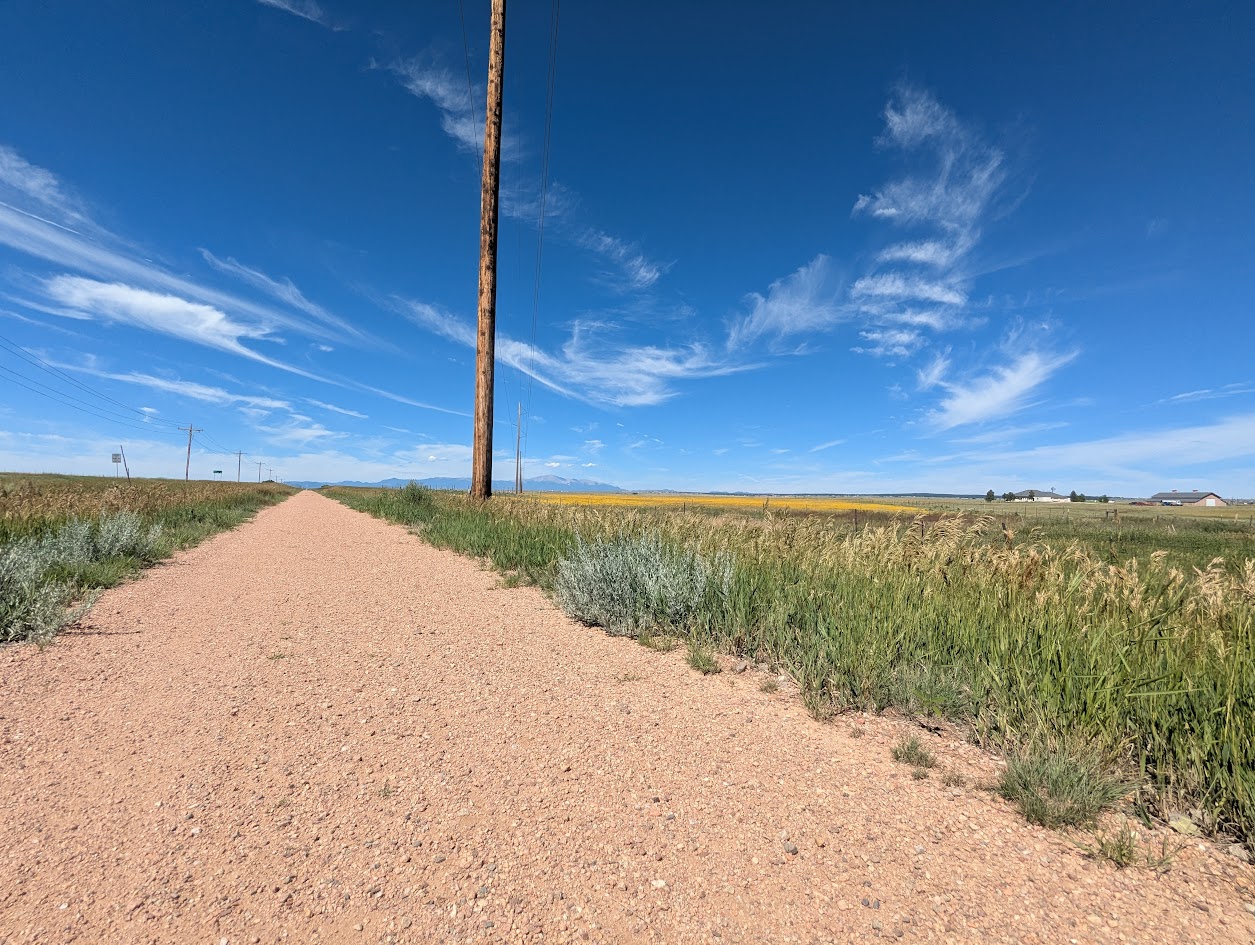
East of Colorado Springs, the Rock Island Regional Trail continues through Falcon and Peyton along the same historic railroad alignment. This segment provides a more rural experience, connecting growing communities and open landscapes while preserving the legacy of the former rail corridor.
Location: Eastern El Paso County, between Falcon and Peyton along the former Rock Island Railroad corridor
Trail Experience
The Falcon and Peyton segment of the Rock Island Trail offers a quieter, more open setting compared to the urban Colorado Springs portion. The trail follows the historic rail bed through prairie landscapes and developing residential areas, creating opportunities for walking, biking, and horseback riding depending on surface conditions.
As development continues in eastern El Paso County, this segment plays an increasingly important role in providing off street trail access and connecting communities to regional recreation opportunities.
Connections
The Falcon and Peyton portion of the Rock Island Trail connects local neighborhoods and open spaces while supporting long term plans for expanded trail connectivity across eastern El Paso County. Future trail extensions and connections are expected to further link this corridor to parks, schools, and regional trail systems.
The Rock Island Trail reflects Colorado Springs’ rail history while serving as a vital recreation and transportation corridor today. Together, the urban and eastern segments illustrate how historic infrastructure continues to shape access, connectivity, and community across the region.
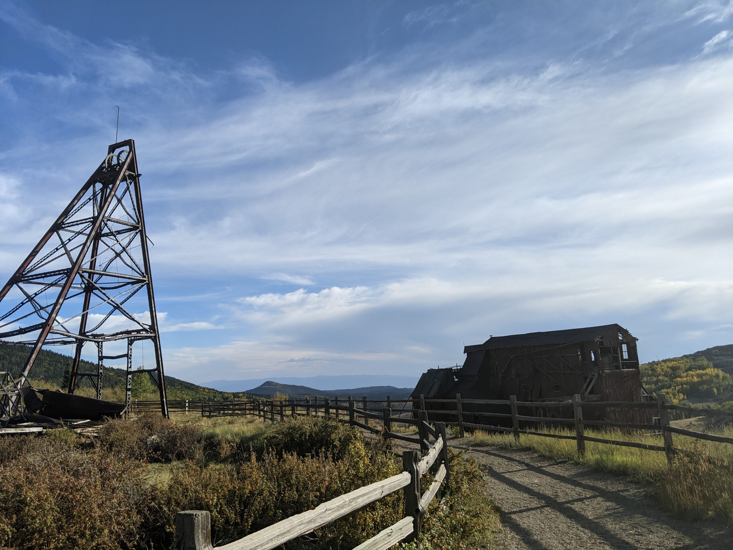
Vindicator Valley Trail in Victor, Colorado, offers a fascinating blend of outdoor recreation, mining history, and scenic beauty in the heart of the Cripple Creek & Victor Mining District. This interpretive loop trail winds through historic mining structures and reclaimed landscapes, giving visitors a glimpse into Colorado’s Gold Rush era while showcasing views of Pikes Peak and the rugged hills of Teller County.
Trails and Recreation
The Vindicator Valley Trail is a 2-mile loop that is rated easy to moderate, making it accessible for most hikers, families, and history enthusiasts. Along the way, you’ll find interpretive signs explaining the mining operations, equipment, and the lives of the people who once worked the area. The trail is popular year-round for hiking, snowshoeing, and photography.
Wildlife and Scenery
While the mining remnants are the highlight, the surrounding landscape is equally striking. Wildflowers bloom in summer, while fall brings golden aspens and crisp mountain air. Mule deer, elk, foxes, and a variety of bird species can often be spotted along the trail. Panoramic views of the Sangre de Cristo and Sawatch mountain ranges add to the experience.
History
Vindicator Valley sits in the heart of the Cripple Creek & Victor Gold Mining District, one of the most productive gold mining areas in the United States during the late 1800s and early 1900s. The trail passes by the historic Vindicator Mine and other structures that once fueled Colorado’s mining boom. Many of these wooden headframes and buildings have been stabilized to preserve them as open-air museums, allowing visitors to connect directly with the region’s past.
Plan Your Visit
Location: Trailhead located just north of Victor, CO off County Road 81 (about 45 minutes west of Colorado Springs). Parking: A gravel lot is available at the trailhead. Parking is free but limited. Hours: Open daily, year-round, from dawn to dusk. Tips:
Interpretive signage is plentiful—allow time to read and explore.
Bring water and sun protection; shade is limited.
Winter visits may require traction devices or snowshoes.
Respect historic structures by staying on designated trails.
Woodmen Trail – Colorado Springs, CO
Woodmen Trail is a neighborhood focused urban trail in northern Colorado Springs that provides an important east west connection through the Briargate area. Following a powerline corridor, this paved trail offers a convenient option for walking, running, biking, and everyday recreation for nearby residents.
Trail Experience
Woodmen Trail is approximately 2.5 miles long and is constructed of smooth concrete. The trail runs east to west between Woodmen Road and Briargate Boulevard, beginning just west of Austin Bluffs Parkway and extending to just past Union Boulevard. Rolling hills along the corridor create noticeable elevation gain and loss, giving the trail a moderate rating despite its relatively short length.
The trail is popular with local users, is stroller friendly, and includes several benches along the route for resting and enjoying the surroundings. Wildflowers fill the fields around the trail in late summer.
Road Crossings and Safety
Users should expect a mix of neighborhood street crossings and larger roadway crossings along Woodmen Trail. Major crossings include Union Boulevard, Rangewood Drive, and Lexington Drive. The Union Boulevard crossing is accessed via the signalized intersection at Briargate Boulevard. Rangewood Drive includes a marked crosswalk, though vehicles may not consistently yield. Lexington Drive features a signalized pedestrian crossing.
Connections
Woodmen Trail transitions into Skyline Trail near the intersection of Briargate Boulevard and Union Boulevard, where the route shifts north. An unmarked connection to Briargate Trail occurs near Yellowwood Drive, allowing users to continue north. Multiple neighborhood access points are available along the length of the trail.
Management
Woodmen Trail is managed by the City of Colorado Springs Parks, Recreation and Cultural Services Department. Phone: 719 385 5940
Cottonwood Creek Trail – Colorado Springs, CO
Cottonwood Creek Trail is a major east west urban trail in northern Colorado Springs and a key connector within the city’s trail system. Following Cottonwood Creek, the trail links neighborhoods, parks, and regional trail corridors while providing a smooth and accessible route for everyday recreation and transportation.
Location: Northern Colorado Springs, following Cottonwood Creek from Powers Boulevard to the Pikes Peak Greenway near I 25
Trail Experience
Cottonwood Creek Trail is just over 6 miles long and features a smooth concrete surface throughout. The trail runs east to west along Cottonwood Creek, beginning near Frank Castello Park at Powers Boulevard and continuing west to connect with the Pikes Peak Greenway and Front Range Trail near I 25.
The trail is generally flat with gentle elevation changes, making it accessible for walkers, runners, cyclists, families, and users of mobility devices. The corridor offers a mix of riparian habitat, open space, and neighborhood views, with long straight segments that are well suited for longer outings or commuting. Benches, trail access points, and nearby amenities allow users to easily tailor trips to their preferred distance and pace.
A dirt trail alternative runs between Union Boulevard and Rangewood Drive, providing a more natural surface option and forming a pleasant 3 mile loop with convenient parking at Cottonwood Creek Community Park.
Road Crossings and Navigation
Cottonwood Creek Trail includes one major street crossing at Union Boulevard. Trail users should use the marked crosswalk at Woodland Hills Drive when crossing Union Boulevard. The trail passes alongside Frank Castello Park and includes a spur connection to Dublin Park; however, accessing Dublin Park requires crossing Dublin Boulevard, which currently does not have a designated pedestrian crossing.
Connections
Cottonwood Creek Trail connects directly to the Pikes Peak Greenway and Front Range Trail just south of the Woodmen Road and Rockrimmon Boulevard area. Multiple neighborhood access points provide easy connections to Cottonwood Creek Community Park, nearby residential areas, and the YMCA. The trail also links to Woodmen Trail and other local trail segments, strengthening north south and east west connectivity across northern Colorado Springs.
Skyline Trail – Colorado Springs, CO
Skyline Trail is a neighborhood focused urban trail in northern Colorado Springs that provides an important north south connection through the Briargate area. Often referred to locally as the Powerline Trail due to its alignment with overhead powerlines, Skyline Trail is well used by nearby residents for walking, running, and biking.
Skyline Trail is approximately 2 miles long and features a mix of wide concrete and dirt trail surfaces. South of Research Parkway, the trail is smooth concrete, while the segment north of Research Parkway transitions to a dirt surface. Rolling terrain creates noticeable elevation gain and loss, giving the trail a moderate difficulty rating.
The trail includes several distinctive switchbacks near Mirage Drive that offer views across the surrounding neighborhoods and open spaces. Despite its urban setting, the corridor provides a sense of separation from nearby roads and is popular for short neighborhood outings as well as longer connected trips.
Road Crossings and Navigation
Skyline Trail includes several street crossings and users should proceed with caution at all crosswalks. Major crossings occur at Briargate Boulevard and Research Parkway. When crossing Research Parkway, users should use the signalized intersection at Chapel Hills Drive for improved safety. Trail signage varies by segment, and awareness is recommended when navigating transitions between surfaces.
Connections
Skyline Trail transitions into Woodmen Trail at Briargate Boulevard, allowing users to continue east west through northern Colorado Springs. A spur trail provides access to Rampart Community Park, which includes a disc golf course, sports courts and fields, and a dog park. The trail passes near High Plains Elementary School and offers views of Reflection Pond, which can be accessed via sidewalks on Parliament Drive.
Sidewalk connections along Briargate Parkway allow access to John Venezia Community Park and the Briargate Trail. Multiple neighborhood access points along the route make Skyline Trail easy to reach from surrounding residential areas.
Skyline Trail plays an important role in connecting neighborhoods, parks, and trails across northern Colorado Springs while offering a moderately challenging route with varied terrain and strong local use.
Shooks Run Trail – Colorado Springs, CO
Shooks Run Trail is a central Colorado Springs urban trail that follows Shooks Run Creek through historic neighborhoods, community spaces, and growing arts and garden corridors. The trail provides an easy, accessible route for walking, biking, and everyday recreation while connecting several key trail systems and local destinations.
Location: Central and southeast Colorado Springs, following Shooks Run Creek from Lilac Street to Fountain Boulevard
Trail Experience
Shooks Run Trail is approximately 4 miles long and runs north to south along Shooks Run Creek. The trail begins near Lilac Street and the Rock Island Trail in the north and continues south to Fountain Boulevard and South Shooks Run Park. The paved surface makes for an easy walk or ride, with a slight downhill grade when traveling south.
The trail is well suited for all ages and abilities, with benches and picnic tables placed along the route for rest and gathering. Shooks Run passes through residential areas and community focused spaces, creating a neighborhood oriented experience that blends everyday use with access to nature. Several street crossings occur along the trail, so users should proceed with awareness at intersections. Several parks can be found along or near the trail.
History and Character
One of the defining features of Shooks Run Trail is its connection to Colorado Springs’ early rail history. At the southern end of the trail, users pass through a historic rail underpass built in 1887, a reminder of the city’s industrial and transportation roots. Beyond the underpass, the trail reaches the Concrete Coyote property, owned and stewarded by Concrete Couch, which has become a hub for community creativity and placemaking.
Connections
Shooks Run Trail connects directly to the Rock Island Trail, expanding access to north south travel across the city. Sidewalks and neighborhood streets provide frequent access points along the route, making the trail easy to reach from surrounding homes and businesses.
With limited on street or sidewalk travel, users can connect to the Pikes Peak Greenway, further linking Shooks Run into the broader Front Range trail network. The trail also passes near Pikes Peak Urban Gardens and the Sustain a Center, where the Trails and Open Space Coalition office is located just off the corridor.
Shooks Run Trail plays an important role in connecting neighborhoods, supporting local community spaces, and strengthening the urban trail network in Colorado Springs. It is a trail built for everyday use, local connection, and continued investment in accessible outdoor spaces.
Rock Island Trail – Colorado Springs, CO
The Rock Island Trail in Colorado Springs follows a historic railroad corridor through the heart of the city, providing an easy, accessible east west route that connects neighborhoods, parks, and major trail systems. Built along the former Rock Island Railroad bed, the trail reflects the city’s transportation history while serving modern recreation and commuting needs.
Location: Central Colorado Springs, running east west alongside Constitution Avenue from Weber Street to Powers Boulevard
Trail Experience
The Colorado Springs segment of the Rock Island Trail is approximately 6 miles long. It runs east west from Weber Street to Powers Boulevard, generally paralleling Constitution Avenue. The trail surface is a mix of concrete and asphalt, creating a smooth and accessible experience for walking, biking, and other non motorized uses.
The trail has a gentle grade, with a gradual uphill slope when traveling east. Several at grade street crossings occur along the route, so users should exercise caution at intersections. The corridor passes through residential areas and urban landscapes, offering a practical and well used route for everyday recreation and transportation.
Connections
Rock Island Trail connects directly to the Shooks Run Trail, creating a continuous north south and east west trail link through the city. With limited street or sidewalk travel, users can also connect to the Pikes Peak Greenway, Homestead Trail, and Palmer Park, making this trail an important part of Colorado Springs’ broader urban trail network.
Midland Trail – Colorado Springs, CO
The Midland Trail is a key east west urban corridor in Colorado Springs, following Fountain Creek and the historic Midland rail alignment. The trail provides a smooth, accessible route through the city, connecting downtown destinations, parks, and major trail systems while offering views of the creek and surrounding landscape.
Location: West and central Colorado Springs, paralleling U.S. Highway 24 (Cimarron Street) from America the Beautiful Park to Ridge Road
Trail Experience
The Midland Trail is approximately 8 miles long and runs east west along Fountain Creek. The trail begins near America the Beautiful Park in downtown Colorado Springs and continues west to Ridge Road. The surface is primarily concrete, making it suitable for walking, biking, and other non motorized uses.
The trail features a mild grade, with a gradual downhill slope when traveling east. Several at grade street crossings occur along the route, with pedestrian signals at major crossings including 31st Street and 8th Street. There is a short gap in the trail between 21st Street and 25th Street, where users are directed to use Naegele Road, a lightly traveled roadway.
The corridor blends urban scenery with riparian habitat along Fountain Creek and passes through areas of public art and community investment. An art bench created by Concrete Couch can be found near 17th Street and serves as a unique landmark along the trail.
Connections
Midland Trail connects directly to the Pikes Peak Greenway, America the Beautiful Park, and the U.S. Olympic and Paralympic Museum. With limited street or sidewalk travel, users can also reach the Foothills Trail, Red Rock Canyon Open Space, and the City of Manitou Springs, making the Midland Trail an important link between urban and foothills recreation.
The Midland Trail plays a central role in Colorado Springs’ trail network, providing access to cultural destinations, regional trails, and everyday outdoor recreation along Fountain Creek.
The Manitou Incline is one of the most popular hiking trails in Colorado. The base of the Incline sits at 6,600 feet. It is, perhaps, the most unique and challenging trail in the country, attracting runners, military, Olympic athletes, and hiking enthusiasts from around the world. It is steep, gaining over 2,011 feet of elevation in 0.88 mile. There are approximately 2,750 steps, although the top step is numbered “2768”; the number of steps changes occasionally with trail maintenance and deterioration. While some athletes can conquer the Incline in 30 minutes or less, it takes most people 1-3 hours to make it to the top. Plus, an additional 1-2 hours to return down the Barr Trail. After you crest the false summit, there are approximately 300 steps to go before reaching the top.
The base of the Incline is located in Manitou Springs near the Cog Railroad. The Inline is free and open to the public, but expect to pay for parking. Even with paid parking, finding a spot can be difficult. In the summer, plan to park in the lot at 10 Old Man’s Trail or in Manitou Springs and take the free shuttle.
PLEASE NOTE: Starting in 2020, users are required to make a FREE reservation online, at coloradosprings.gov/parks/page/manitou-incline. Pets are NOT allowed on the Incline. Remember to bring plenty of water!! This is an extremely difficult climb at high altitude, and the return route on Barr Trail is about 3 miles, it’s about 4 miles round trip. You should be in good physical shape and acclimated to Colorado altitude before attempting this trail.
Connections: The Northern Incline Return Trail offers two new return options for hikers, both located in the bottom half of the Incline. The first return is located at railroad tie #395 and the second is at #1300, approximate halfway point. From tie #1300, the trail to return down to the trailhead is roughly 1.5 miles. From tie #395, it is about a half a mile hike down. About three-quarters of the way up the Incline, around step #1800 there is a turnoff to the Barr Trail, locally called “The Bailout.” If you don’t have it in you to take on another 1000 steps, this is where you should exit. The top of the Incline also connects to Barr Trail allowing hikers to trek to the summit of Pikes Peak or return to the base of the Incline.
History: Completed in 1907, the Manitou Incline was once a cable tram built to support the construction of a hydroelectric plant and its waterline. After performing this service the railway was then purchased by Dr. Brumbach and turned into a tourist attraction. The Incline boasted a 16-minute ride to “scenic splendors”, 10 miles of hiking trails in Mount Manitou Park, and claimed to be the “longest and highest incline on the globe.” Spencer Penrose bought the Incline in 1923 and made it part of his tourist attraction empire, the cars were upgraded to allow for a retractable roof and more safety. The summit station was again rebuilt in 1958 and lasted until it was dismantled upon closure of the Incline in 1990. A rock slide damaged a section of track in 1990, so the Manitou Springs Incline was closed down. The rails were removed, but the railroad ties remained in the form of a massive staircase.
Nearly 20 years of unmanaged trespass and use of the Incline resulted in significant erosion on the mountainside, dangerous trail conditions, traffic congestion and uncontrolled parking. In 2010, the City of Colorado Springs negotiated pursing legal access to the Incline corridor, and both Colorado Springs and Manitou Springs entered into an Intergovernmental Agreement to plan for formally opening the Incline for public recreation. In 2011, the Manitou Incline Site Development and Management Plan was drafted. After many years of wrangling and an actual Act of Congress, the Incline was made legal in February of 2013.
Volunteer: Contact the Incline Friends to see how you can help, inclinefriends@gmail.com.
Homestead Trail – Colorado Springs, CO
The Homestead Trail is a long, neighborhood-spanning urban trail that weaves through eastern Colorado Springs, connecting parks, open spaces, and residential areas. Stretching approximately 7 miles in total, the trail offers a challenging and varied experience for cyclists, runners, and walkers looking for a route that blends recreation with everyday city connectivity.
With rolling terrain, multiple park connections, and future expansion planned, the Homestead Trail plays an important role in the city’s growing trail network.
Trails and Recreation
The Homestead Trail is divided into two main segments, separated by a short on-street connection.
Northern Segment (≈2 miles): This portion branches off the Cottonwood Creek Trail about a mile south of Woodmen Road. It travels southeast before ending at Templeton Gap Road, where users must transition to sidewalks to reach the southern segment.
Southern Segment (≈5 miles): The more commonly used section begins at the High Chaparral Open Space parking lot, located off Stetson Hills Boulevard (accessible when traveling eastbound). From there, the trail travels south, crossing several major streets, passing neighborhood parks, and eventually terminating at Radiant Drive.
The Homestead Trail is not an easy ride or walk. Users should expect rolling hills and a mix of trail surfaces, including asphalt, concrete, and dirt. While much of the trail is paved, some sections are rough or deteriorated, adding to the challenge.
Parks and Connections
One of the Homestead Trail’s strengths is its proximity to numerous parks and open spaces. Along the route, the trail travels through or alongside:
Old Farm Park
Rudy Park
Homestead Park
Villa Loma Park
Penrose Park
The trail connects directly to Cottonwood Creek Trail, and with some street or sidewalk travel, users can also access Palmer Park and the Rock Island Trail. The Homestead Trail shares a trailhead and parking area with High Chaparral Open Space, making it a key access point for both trail and open space users.
Management and Stewardship
The Homestead Trail is managed by City of Colorado Springs Parks, Recreation and Cultural Services, which oversees maintenance, safety, and long-term planning for the trail.
Because the trail passes through busy urban areas, stewardship focuses on:
Safe street crossings
Trail maintenance and surface improvements
Balancing recreation with neighborhood use
Improving long-term connectivity
Plan Your Visit
Access Points:
Cottonwood Creek Trail connection (north)
High Chaparral Open Space parking lot (south, via eastbound Stetson Hills Blvd)
Parking:
Available at High Chaparral Open Space
Limited neighborhood access points along the route
Hours: Open daily, dawn to dusk
Tips:
Expect hills and uneven surfaces
Use caution at major street crossings
Bring water—shade is limited in many sections
Check conditions before biking due to rough pavement in spots